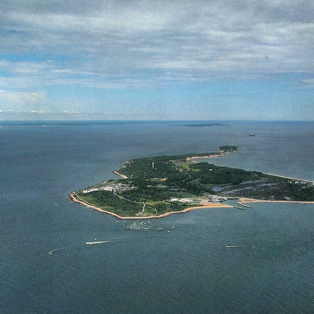
Plum Island sits off the northeast coast of Long Island, New York. Throughout the last two centuries it has vacillated between civilian and government use. Colonists began settling here in the late seventeenth and into the eighteenth centuries, and named it for the abundant native plum trees. British raiders bedeviled the island during the Revolutionary War. Sleepier times ensued during much of the nineteenth century.
Residents farmed, raised livestock, and generally kept to themselves. Eventually the government erected a lighthouse to guide ships through Long Island Sound. The final private owner wanted to turn the island into a summer resort but failed. Nonetheless, nothing much distinguished Plum Island from any other coastal island along the eastern seaboard of the United States.
Government Control
Things got more interesting when the government purchased a large tract on Plum Island in the late nineteenth century. Here they erected Fort Terry, a link in the protective shield for New York City during the Spanish-American War. Spanish forces never threatened New York during that rather lopsided conflict, and Fort Terry never fired a shot in anger.
The government acquired the remainder of the island after the war. Then it upgraded its military capabilities, and operated a base through the end of the First World War before deactivating it. Fort Terry returned to active duty during the Second World War as an army training camp and as a supply depot for submarines and patrol boats. Once again it returned to inactive status at the conclusion of hostilities. The U.S. Army Chemical Corps began refurbishing it in the early 1950’s and soon passed it to the U.S. Department of Agriculture (USDA) to study foot-and-mouth disease in livestock.
Animal Disease Research
Individuals who work at the Plum Island Animal Disease Center, a part of the Agricultural Research Service, take an employer-provided ferry each day to their jobs either from Orient Point, New York or Old Saybrook, Connecticut. Outsiders cannot set foot on Plum Island without an official reason. However most probably wouldn’t want to do that anyway because it’s a Biological Safety Level 3 (BSL-3) facility. That means it deals with nasty animal pathogens. Its remote location makes it advantageous for these types of situations.

“Plum Island is located two miles from Orient Point. It was created by retreating glaciers and is naturally isolated. The shrub covered island measures 643 acres, and is located between the north and south fork of Long Islands “fish tail” east end, next to Gardiner Island. Prevailing winds in this area generally blow out to sea, which makes Plum Island a safe place to experiment with dangerous infectious diseases.”
Long Island Historical Journal, Vol. 16, Nos. 1-2, page 176
Conspiracy Theories
That’s what the government claims takes place on the island. Naturally, Plum Island’s restricted access and officially-stated purpose give rise to all manner of speculation. People wonder what may or may not actually be happening there.
Conspiracy theories related to Lyme Disease[1], the Montauk Monster, and biological warfare all circulate freely on the Internet with varying degrees of veracity and seriousness. Regular readers know that I’m rather jaded by nature. So within that context I’ll simply note that I’m not making any claims or value judgments, I’m merely pointing out the existence of these theories. They make the story more interesting.
The Department of Homeland Security controls Plum Island today although USDA continues to operate its lab there. On January 16, 2009, DHS finalized plans to shut down the facility by 2015 and move it to a new $450 million research site in Manhattan, Kansas. It will be located close to an abundant source of scientists from Kansas State University. It will also be upgraded to handle even nastier pathogens up to BSL-4.
What the Future May Hold
You would think most people within blowing distance of Plum Island would be happy with that decision. BSL-4 works with the worst-of-the-worst; things that are easily transmitted among humans and are extremely dangerous, like hemorrhagic fevers including Ebola. Think bio-suits and oxygen tanks. Downwind residents in heavily populated areas of Connecticut a few miles across Long Island Sound seem pretty content with the move. Lots of people would like to see Plum Island converted into recreational use or as a facility with less controversial research pursuits. Perhaps renewable energy technology?
It’s a different story in New York. Plum Island brings lots of good-paying jobs to a remote corner of the state. New York politicians now sense an opportunity to reverse the DHS decision during the change in Presidential administrations. They point to a body of evidence including a 2008 report from the government’s General Accountability Office:
“GAO found that the Department of Homeland Security (DHS) had neither conducted nor commissioned any study to determine whether work on foot-and-mouth disease (FMD) can be done safely on the U. S. mainland.”
GAO: HIGH-CONTAINMENT BIOSAFETY LABORATORIES
Depending on how this all works out, you might be able to visit the historic remains of Fort Terry or climb the tower to the Plum Gut Light during your lifetime. If Plumb Island does return to public use then I’ll be in line. I have a fascination both with coastal fortifications and with lighthouses. However, you better believe I’ll make sure the place is well scrubbed before I arrive!
12MC Loves Footnotes!
[1]The town of Lyme, Connecticut — which lends its name to the disease — is perhaps fifteen miles away from Plum Island as the crow flies (or as the wind blows). Thus, this set of conspiracy theories rely on a proximity argument.

Leave a Reply