I outlined a couple of odd time zone anomalies within the United States in Part I. So here I continue the effort with several more examples. While none of these are quite as extreme as the Idaho instance discussed in the last installment — although one comes pretty close — they all represent places where one can travel due East and have to turn a clock backwards rather than forward. In other words, exactly the opposite of what one would normally expect. The phenomenon happens in tiny pockets but it exists. Visitors can experience it firsthand.
In the United States, the Federal government reserves the right to define time zones. States may chose to recognize Daylight Saving Time or not, but they cannot alter time zone boundaries. Those definitions occur in Title 49 of the Code of Federal Regulations which relate to matters of transportation. Specifically we look to Subtitle A, Part 71. I am going to quote directly from the Code below, so prepare yourself. It will either fascinate you or bore you to tears. You can always enjoy the pictures and ignore the text.
Anomaly in North Dakota
The situation appears in a couple of spots south of the Arnegard/Watford City/Mandaree area (map) and near the northern unit of the Theodore Roosevelt National Park in North Dakota. Here the boundary between Mountain and Central Time follows the the Little Missouri River. No roads seem to cross the boundary at either anomaly so a visitor would have to conquer these on foot, or more properly, by kayak or canoe.

Here’s the legal description:
“..southerly along the Montana-North Dakota boundary to the Missouri River, thence southerly and easterly along the middle of that river to the midpoint of the confluence of the Missouri and Yellowstone Rivers, thence southerly and easterly along the middle of the Yellowstone River to the north boundary… [through a bunch of township grids points but I don’t have a good map to show any of that] … thence south to the middle of the Little Missouri, thence easterly and northerly along the middle of that river to the midpoint of its confluence with the Missouri River…”
Anomaly in Michigan
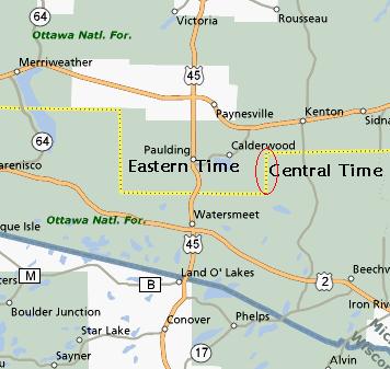
Then I found a better example in Michigan’s Upper Peninsula. Focus on the town of Paulding which is right in the middle of it (map). Da Yoopers don’t think much of the rest of the state, in fact they often consider themselves a separate state It’s natural they might have more affinity with their Wisconsin neighbors in Central Time than someone hundreds of miles away in Detroit in Eastern Time.

Indeed, a large slice of the southern Upper Peninsula follows Central Time. County borders provide a dividing line. A little jog in lower Ontonagon County creates the time conundrum. Multiple minor roads in the southeastern part of the county allow visitors to experience this phenomenon, driving due east into neighboring Iron County (map).
In case you want the gory details:
“…to the west line of Ontonagon County, thence south along the west line of Ontonagon County to the north line of Gogebic County, thence southerly and easterly along the north line of Gogebic County to the west line of Iron County, thence north along the west line of Iron County to the north line of Iron County…”
Anomaly in Kentucky
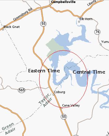
Next we move onto Kentucky where once again the anomaly exists. Here the boundary between Central and Eastern Time also follows county lines. Taylor County swings down in a “V” shape, so a traveler driving through the lower part of the county into Adair County would find a surprise if he didn’t know the secret. Coburg would be a good starting point, just south of this remarkable spot.

This one’s pretty easy to describe:
…thence southeasterly along the west (southwest) lines of Taylor County and northeasterly along the east (southeast) line of Taylor County…
[UPDATE: I actually visited this anomaly in person in 2013!]
Anomaly in Florida
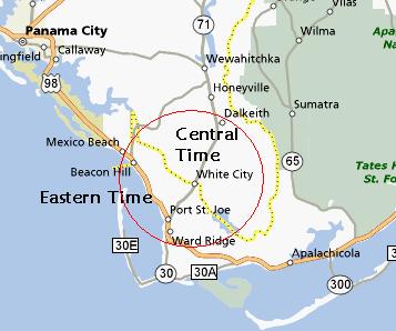
And now the best. The border between Central and Eastern Time gets really bizarre through the Florida Panhandle. A whole prong of Eastern Time exists west of Apalachicola and runs half way up to Panama City. It offers several opportunities to experience the anomaly first-hand.

Notice the tiny spike north of Beacon Hill. There’s even a town located within the sliver and it’s called Overstreet. You can see the phenomenon pretty well in this satellite image. Overstreet sits in Eastern Time. However, Central Time hems it in tightly on three sides! That’s because it’s wedged between the Intracoastal Waterway and the western edge of the Gulf County line which in combination defines the time zone border through this corner.
More precisely:
…thence westerly along the center of the Jackson River to its intersection with the Intracoastal Waterway, thence westerly along the center of the Intracoastal Waterway to the west line of Gulf County, thence southerly along the west line of Gulf County to the Gulf of Mexico.
I’m sure there are more examples but these were the obvious ones that jumped out during my quick survey.

Leave a Reply