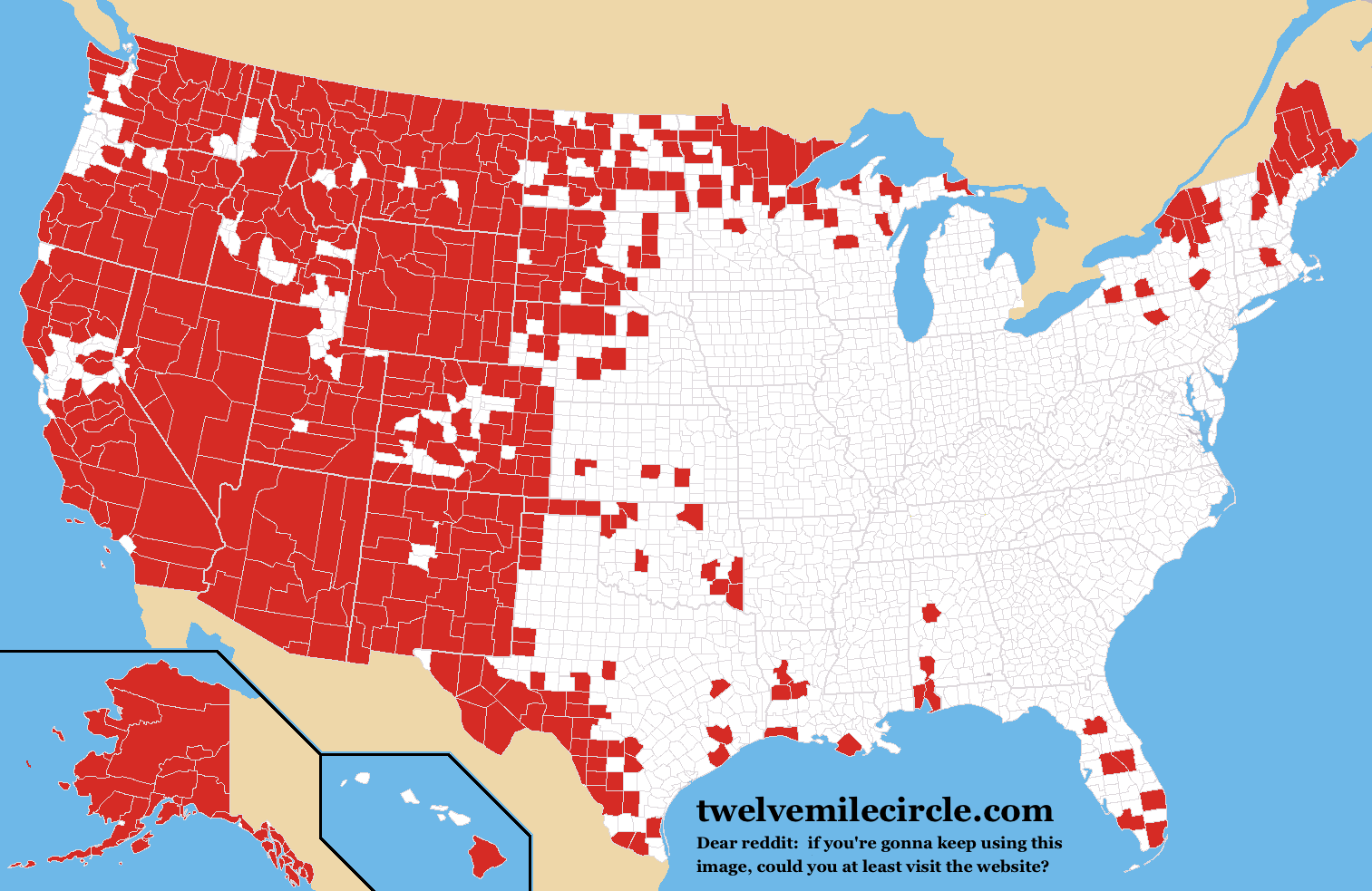
Something has to be the smallest. Most of us, or at least those of us in the 12MC audience from the United States, probably know that Rhode Island (map) claims this honor for the U.S. So exactly how small is it though? One hears frequently of individual counties within the United States as being “larger than Rhode Island.” It’s certainly true. But is it a rare occurrence or is it something altogether more common?
Examining Rhode Island

Little Rhody makes up for its diminutive size by having a much longer official name. Officially it’s “Rhode Island and Providence Plantations”. Some might consider that a bit of a Napoleon Complex although the truth is rather mundane. The name represents the merger of two separate predecessor colonies. So take heart that Rhode Island could have been even smaller than it is today.
Rhode Island formed after the banishment of Roger Williams from the Massachusetts Bay Colony due to religious differences in 1636. Tucked into a corner as it were, Rhode Island didn’t have the same opportunities to gather or solidify territorial claims further west. Then it became even more of an outlier as the new nation formed and expanded to the Pacific.
Rhode Island encompasses 1,214 square miles (3,144 square kilometers). Actually, I’m being generous since that calculation also includes its territorial waters. If one were to examine only dry land it would cover only 1,045 square miles. However, for the sake of comparison, I wanted to give Rhode Island the full benefit of the doubt. So I chose to inflate its size to the largest plausible number.
Comparing to Counties
From there it was pretty easy to consult the U.S. Census Bureau’s American FactFinder. There I downloaded square mileage and population numbers for each of the 3,142 individual counties and county-equivalents. I knew Rhode Island was small but I didn’t realize just how small it was until I calculated the results and created a map. There are an astounding 504 counties in the U.S. that are larger than Rhode Island. That total would jump to 622 counties if I considered only Rhode Island’s dry land.

Rhode Island — including its territorial waters — is smaller than each of the counties marked in red. Practically every county west of the Great Plains is larger. There are others scattered around the eastern half of the nation too. That includes one actually bordering Rhode Island itself: Worcester County, Massachusetts (map).
I’ve not calculated this as a percentage of the overall United States landmass. However, it’s safe to say it’s considerable. Eyeballing it I’d conclude the larger counties cover somewhere between a third to a half of the Lower 48 states. Throw in Alaska where only a tiny handful of boroughs are smaller than Rhode Island, and I’ll bet it represents at least half of all U.S. acreage.
You can open that image within another tab or window if you’d like to take a closer look. I’ve shrunk it down to fit into the size limitations of this article. The underlying graphics file is considerably larger.
Alternate Rhode Islands
This got me thinking about the possible “Alternate Rhode Islands” out there. Surely, the preponderance of larger counties contain thousands of empty acres with nary a soul living amongst them. It’s unfair to compare Kenedy County, Texas and its 416 residents (which we’ve discussed before) to Rhode Island’s population of 1,052,567, as an example. Let’s set those sparsely-settled counties aside.
I still felt that there were probably a decent set of counties both larger than Rhode Island and greater in population. A quick data sort revealed a dozen instances. Each of these could easily become a standalone state based upon Rhode Island criteria. Additionally I’ve proposed a potential capital city for each of these fictional states:
| Potential State | Derived from | Capital City | 2010 Population |
| Los Angeles | California | Los Angeles | 9,818,605 |
| Harris | Texas | Houston | 4,092,459 |
| Maricopa | Arizona | Phoenix | 3,817,117 |
| San Diego | California | San Diego | 3,095,313 |
| Miami-Dade | Florida | Miami | 2,496,435 |
| Riverside | California | Riverside | 2,189,641 |
| San Bernardino | California | San Bernardino | 2,035,210 |
| Clark | Nevada | Las Vegas | 1,951,269 |
| King | Washington | Seattle | 1,931,249 |
| Santa Clara | California | San Jose | 1,781,642 |
| Bexar | Texas | San Antonio | 1,714,773 |
| Palm Beach | Florida | West Palm Beach | 1,320,134 |
Maybe I should also note a couple of counties that are ” near misses” with populations just below Rhode Island. Those included Pima County, Arizona and Fresno County, California.
Best Fits
Then I added a final dimension in an attempt to determine which of these counties were most like Rhode Island in terms of population density. Rhode Island has about 867 people per square mile. Some of the counties had considerably greater population densities. Los Angeles and Harris both had nearly triple the density of Rhode Island. Imagine the behemoth of a state either one of those could become should they ever split away.
The best Rhode Island proxies are King and San Diego. King is probably the better example. It comes quite close to being of similar size and population to Rhode Island. I’ll bear that in mind the next time I’m in Seattle. It could legitimately anchor another Rhode Island-like state.

Leave a Reply