I requested an additional account on the Mob Rule county counting website recently. I’d been planning a couple of trips for 2016. This including one focused primarily on adding new counties to my lifetime tally in an obscure geographic corner of Appalachia. So I’d been using this spare account to calculate “what-if” scenarios. Naturally, I didn’t want to disturb my existing map in the process so a second account came in handy. Twelve Mile Circle readers will likely see maps generated by this account in the future as I chart further adventures.
Then it occurred to me that I will need to hit back roads a lot more often. That’s the only way I’ll ever fill in all the blanks and doughnut holes in my personal capture map. Those efforts will diminish my pace although they will also allow me to experience out-of-the-way places where few people tread.
It made me wonder exactly how much of the United States one would miss using only the Interstate Highway System. Really, this wasn’t a question that demonstrated any greater practical purpose. But that never stopped Twelve Mile Circle from going down a rabbit hole before.
It wasn’t completely pointless I rationalized. I could use the results to separate the “easy” counties from the more difficult ones, roughly speaking. Amateur county counters would stick primarily to the Interstate Highways while the truly dedicated hunters such as myself would need to veer into the empty white spaces. I supposed it made me feel more serious about my pursuit by separating me from the pack. It fed into a mythology. Can one truly appreciate the United States unless one ventures away from the highways?
Drawing the Map
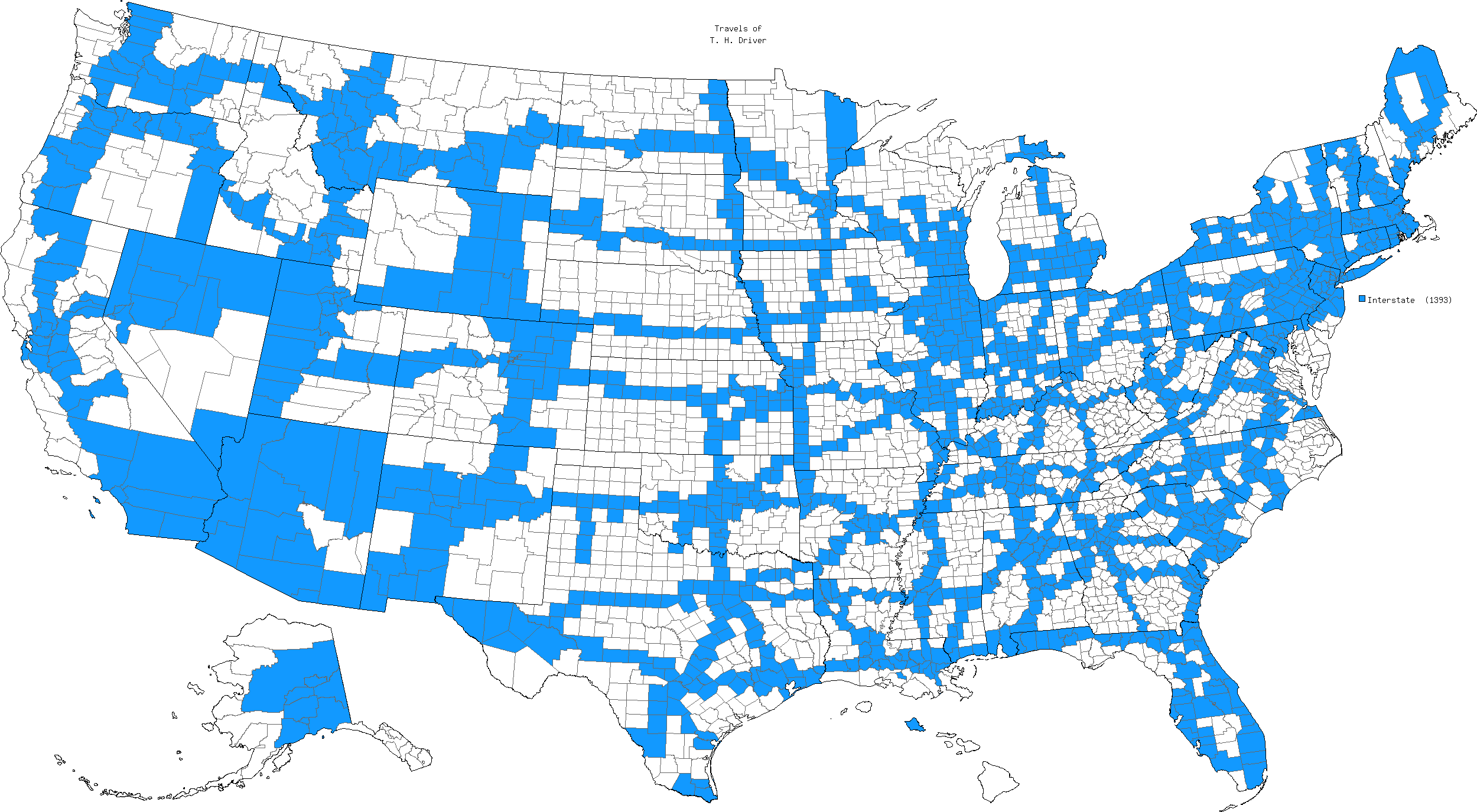
So I began by making a map of counties served by Interstate Highways, both two-digit and three-digit. Readers would probably want to open the image in another tab to get the full-sized image.

I couldn’t guarantee that I marked every county served by an Interstate Highway because I created this manually. I was still finding new ones that I’d missed hours after I thought I’d finished it. Even so, this should be close. Please feel free to offer corrections and I’ll update the map. For those wondering about the odd title, “Travels of T. H. Driver, ” that was simply my initials plus the word Driver. I had to give the dummy account a name and that seemed as good as anything.
Mob Rule includes a lot of features that I’ve enjoyed over the years. One involves simple statistics to catalog counties visited by state. It produces a nice summary table of counties visited and percentages of states covered. I placed those data into a Google Docs Spreadsheet that readers should feel free to review if interested.
Mob rule assumed everyone knew the 2-letter postal code abbreviations for each state so I can’t help you if you don’t know them. I didn’t feel like typing them out. Wikipedia provided a nice cross-reference though. I sorted states by percentage completed from highest to lowest. However, one could rearrange the table in reverse order, alphabetically, or whatever direction one might desire. Go ahead and try it out. It won’t harm the underlying document.
Winners and Losers

Some observations jumped out. For example, county counters who stuck solely to Interstate Highways wouldn’t visit even half of the counties in the United States. The total would hit 44% but who’s counting? The chart also sifted winners from losers. I discarded the District of Columbia’s 100% although county counters considered it both a state and a county for their purposes (in reality neither). So, discounting that, Interstate Highways served 7 of 8 counties (87.5%) in Connecticut for the top spot. Then it ranged all the way down to 16 of 77 counties (17.2%) for Nebraska at the bottom.
Results followed intuitive patterns. Small northeastern states with large populations contained numerous Interstate Highways. Large, expansive Great Plains states with smaller populations featured fewer of them. New York and Pennsylvania posted particularly impressive results given the number of counties contained within each of them. Both punched above 70 percent.
Anomalies
Of course there were some anomalies.
- Someone would likely mention the paradox of Interstate Highways in Hawaii so I’ll simply link to the Federal Highway Administration’s explanation (i.e., “the Interstate System is more than just a series of connected highways. It is also a design concept“) and get that out of the way.
- The same condition existed in Alaska although the roads didn’t feature Interstate Highway signage.
- Additionally, I included all of the so-called Secret Interstates for the sake of completeness.

However, I didn’t know about the bizarrely disconnected set of Interstate Highways in the southernmost tip of Texas until now. Those exist between Brownsville and McAllen (map). They form a rough U-shape, outlined by I-69E, I-2 and I-69C (for central?). One would need to hop a plane or drive through Mexico to capture these Interstate counties without disturbing non-Interstate counties surrounding them. Nobody would ever do that because it would be absurd. Or would they?
I enjoyed the exercise even if it didn’t serve much of a useful purpose. It did confirm in my mind that people visit Interstate counties more frequently in general than non-Interstate counties. But that’s not particularly insightful or controversial. One can observe that quite easily by comparing the map I created with Mob Rule’s composite map of all county counters. The patterns looked strikingly similar.

Leave a Reply