Focused on Counties

I’m planning for three, maybe four road trips of significant length coming up over the next several months. All of them will involve significant County Counting components. While I’ve put a big dent into my quest to visit every county in the United States, the total still represents considerably less than half of those available. I’ve been pondering several strategies as I’ve examined places that will require significant effort. That led me to stare at a lot of county maps lately, examining them from a variety of perspectives. I don’t think I found anything earth shattering although I tucked a few observations away for future reference.


Square Miles (land area only)
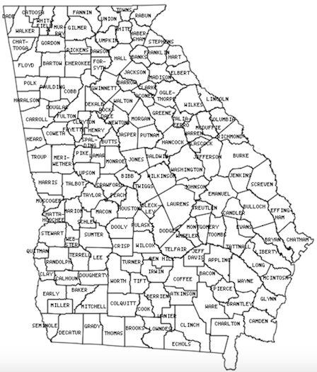
Georgia Counties. Map via mob-rule.com/home
Georgia Counties

Georgia continues to confound me. How will I ever finish a state with so many tiny counties crammed within its borders? For sure, I will see every corner and crevice of Georgia by the time I finish. I examined a bunch of other states with tiny counties and I began to wonder which one had the smallest average county size. Being the precise person that I am, of course I created a spreadsheet to calculate and rank them. The smallest average county size belonged to… Rhode Island averaging 207 square miles per county (feel free to convert to square kilometres if you prefer). That hardly seemed a challenge though. Rhode Island only has 5 counties. Plus, I’ve already visited every one of them.

Second place, with an average county size of 297 square miles, went to Virginia. I’ve already finished that one too. That was a difficult feat — and I live there! However Virginia came up near the top only because it had those 38 insanely small Independent Cities. Take away those and Virginia would fall to #8 on the list. Next came Kentucky and New Jersey, and only then Georgia, followed by Tennessee.

Every state in that grouping featured an average county square mileage somewhere in the 300’s. All of them will be difficult to finish except for New Jersey which has only 21 counties. Georgia has 159! Texas fell way down on the list with an average county size of 1,028 square miles. Even so it will be frustratingly difficult because of its immense size combined with a jaw-dropping 254 counties.

I figured larger western states with fewer counties would be an easier accomplishment. That might be true in general. However, Alaska might be the exception. If one considered its boroughs and each of the individual Census Areas of the Unorganized Borough (all considered “county equivalents” for these purposes) they would hit an average size of 19,677 square miles. Yet it would be difficult, time-consuming and expensive to visit them all. It would probably involve chartering private airplanes.


Population (2016 estimates)

Mount Rushmore. Photo by howderfamily.com; (CC BY-NC-SA 2.0)

I didn’t stop there however, maybe because I was on a roll, although my next tangent had nothing to do with County Counting. The spreadsheet was already set up so it was pretty easy to add another column and replicate the study with populations. Just because. Why not?

South Dakota featured the fewest people per county on average, with only 13,113 residents each. North Dakota and Montana followed next in line, each with an average of fewer than 20,000 people per county.

Alaska served as an interesting anomaly once again. I figured it would be lower on the list than #6. However it had a fairly sizable population even though nearly everyone lived in only two boroughs; Anchorage and adjoining Matanuska-Susitna. That skewed things. Rankings probably would have changed if I’d bothered to examine median rather than average. That would have entailed effort and I’m lazy so we’ll never know.

California fell at the complete opposite end of the spectrum. There, the average county population hit an astounding 676,724 residents. The average California county had a larger population than the entire states of Wyoming or Vermont! Crazy.

I found another oddity. Two very different states had nearly the same number of counties and total population: Arizona and Massachusetts. That happened despite Arizona being nearly 15 times larger than Massachusetts. It served as a wonderful demonstration of larger western states with larger county sizes in contrast to smaller eastern states with smaller counties.


The Complete Oddball

Washington Monument on the 4th of July. Photo by howderfamily.com; (CC BY-NC-SA 2.0)

What if the District of Columbia ever became a state? DC would be composed of a single county of 61 square miles, and a population of 681,170 residents. That would make DC the state with the smallest average county size, by far. It would also be the state with the largest average county population. County counting would be really, really easy there too.

I travel into the District of Columbia nearly every day so I think I have that one covered.

Comments

10 responses to “Focused on Counties”

  1. Fritz Keppler Avatar
    Fritz Keppler

    I believe that each of the Alaska Census Areas is reachable by scheduled aircraft or ferry. I’m missing 7, having reached all but North Slope, Nome and Northwest Arctic by car or ferry, so now I have to fly at some point to Bethel (Bethel), Kusilvak (Hooper Bay), Dillingham (Dillingham) and Bristol Bay (Naknek). Yakutat, Wrangell and Skagway can be reached by car or ferry.

  2. Mike Lowe Avatar

    I can see how Virginia was hard. It was hard for me to map my counties there. Some of the highways I used went just a bit outside some of the cities. Oops. When I got a few NoVa and MD places this year I made darn sure I got the NoVa ones by driving by city hall. I’m looking at you City of Fairfax with your exclave of Fairfax county inside of it.

    Getting 100% of Texas took several dedicated and well planned trips. That is especially true living in one corner of the state (the Houston area). One trip went haywire and I had to leave four counties unacquired north of Abilene. That took another trip to fix.

    Getting 100% of Louisiana took a while. Getting 100% of New Mexico wasn’t too bad. I’m two counties short in Arizona. Hopefully I can get them this summer when I visit Phoenix for a convention.

    I finally acquire Miami-Dade county this Friday. I’m leaving there on a cruise. 🙂

  3. Mike Lowe Avatar

    I wanted to discuss Alaska in a separate post. My family is doing an Alaska cruise from Seattle this June. The Inside Passage trip will also get me some BC counties or equivalents. I’m concerned about cell phone coverage there. It might be hard to use the Mob Rule or Mapquest sites that show county lines well.

    I have a plan. I figure I can use my phone’s GPS and compass to make log entries of where I am and in what direction I’m looking at when I see land. I can look 360 degrees around when I’m on deck. At home I should be able to plot the latitude and longitude coordinates and see where I was.

    I know I will miss some counties at 3 AM. Oh well. I’ll do my best. I may never be there again. Hopefully my plan works well.

  4. Greg Avatar
    Greg

    I wonder how common county quadripoints are. That map of Georgia appeared to have one right in the middle of the state, which is unusual considering how oddly shaped the counties are. My home state of Ohio has two county quadripoints (I think), both of which I’ve visited because I have lived in counties adjacent to them.

    1. Fritz Keppler Avatar
      Fritz Keppler

      I come up currently with 187 in all.
      Not sure if this set of tabs will work here:
      InternalPoints/Shared Points/Points Shared With/Counties Involved

      AK – – – –
      AL – – – –
      AR 1 1 LA 6
      AZ – 1 CO, NM, UT 1
      CA 1 – – 4
      CO 2 2 AZ, NM, UT 10
      CT – – – –
      DC – 1 MD, VA 1
      DE – – – –
      FL 8 1 GA 25
      GA 8 2 FL, NC, SC 30
      HI – – – –
      IA 36 – – 78
      ID – 1 UT 2
      IL 3 – – 12
      IN 3 1 OH 13
      KS 9 1 NE 28
      KY 1 – – 4
      LA 1 1 AR 6
      MA – – – –
      MD – 1 DC, VA 1
      ME – – – –
      MI 15 – – 36
      MN 2 2 SD 11
      MO – – – –
      MS 7 – – 22
      MT – 2 ND, (AB, BC) 4
      NC 6 3 GA, SC 23
      ND – 2 MT, SD 4
      NE 7 2 KS, SD 25
      NH – – – –
      NJ – – – –
      NM – 1 AZ, CO, UT 1
      NV 1 – – 4
      NY 1 – – 4
      OH 2 1 IN 10
      OK 1 – – 4
      OR 1 – – 4
      PA 2 – – 8
      RI – – – –
      SC 2 3 GA, NC 13
      SD 2 4 MN, ND, NE 14
      TN – – – –
      TX 31 1 (CH) 81
      UT 2 3 AZ, CO, ID, NM 10
      VA 5 2 DC, MD, WV 22
      VT – – – –
      WA 1 – – 4
      WI 6 – – 21
      WV 1 1 VA 6
      WY – – – –

      _CAN AB – 1 MT –
      _CAN BC – 1 MT –
      _MÉX CH – 1 TX –

      168 43 (19 individual points) 552

    2. Fritz Keppler Avatar
      Fritz Keppler

      Darn, it wouldn’t tab. But after the state abbreviation, the first number refers to the number internal points, the second the number of points shared with another state, then the states the points are shared with, and finally the number of counties involved. This includes the quintipoint in Lake Okeechobee. The dash indicates zero.

  5. Fritz Keppler Avatar
    Fritz Keppler

    168 internal points plus 19 shared points make 187 in all.

  6. Gary Avatar

    There are numerous county quad-points here in Florida (places where four counties meet). There are at least 7 that I know of:

    Charlotte-Glades-Hendry-Lee
    Desoto-Highlands-Glades-Charlotte
    Hillsborough-Polk-Hardee-Manatee
    Polk-Osceola-Okeechobee-Highlands
    Lake-Orange-Osceola-Polk
    Union-Bradford-Clay-Alachua
    Washington-Jackson-Calhoun-Bay

    and, of course, the one spot in Lake Okeechobee where FIVE counties meet:
    Glades, Okeechobee, Martin, Palm Beach, and Hendry

    Also, Polk County borders TEN different counties! That must be a high for a county here in Florida. It borders (starting in the north, and running clockwise):
    Sumter, Lake, Orange, Osceola, Okeechobee, Highlands, Hardee, Manatee, Hillsborough, and Pasco.

    Jackson County borders nine. Starting in the north and running clockwise, it borders: Geneva (Alabama), Houston (AL), Seminole (Georgia), Gadsden, Liberty, Calhoun, Bay, Washington, and Holmes.
    NOTE: Jackson County is the only county in Florida that borders both Alabama and Georgia.

  7. James D Avatar
    James D

    And I see Coffee County right next to Bacon County. Were these named over breakfast?

  8. harry Avatar
    harry

    a weird thing ive noticed with things like this, is new jersey seems to be somewhere on the list, and it always seems to be 3rd or 4th, maybe im just noticing it since im from there but atleast half of these lists have new jersey on 3rd or 4th

Leave a Reply

Your email address will not be published. Required fields are marked *

Latest Comments

  1. Hi Mr. Howder — Just going from memory, I recall that your “rule” for counting a nation/state/county is “if I’m…

  2. Does anyone have actual music to the song – Tanaha ,Timpson. Bobo and Blair ?? It was recorded by Tex…