Once again I find myself pondering the mapping tools available through Google Analytics. I follow those daydreams to wherever they may lead. This time a visitor from Bandar Seri Begawan in Brunei Darussalam caught my eye. So mentally I set off for the Southeast Asian island of Borneo to see what I might find.
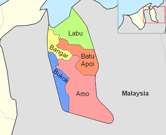
A quick glance at a map reminds me that two physically distinct sections compose Brunei. Temburong, with its capital in Bangar, forms a single district (daerah) encompassing the entire eastern portion of the country. Fewer than 10,000 people or only about 3% of Brunei’s population live there.
An Exclave
Temburong is an exclave. Malaysia separates it from the larger and more populated portion of Brunei. Technically it is a “practical” exclave because its territorial waters run contiguously through Brunei Bay. However, even taking this into consideration, it is still a rather unusual arrangement. It’s analogous to the Point Roberts situation in the United States.

History
Brunei Darussalam is a remnant of a much larger Brunein sultanate that once encompassed all of Borneo and parts of the Philippines at its height. Its final contraction came as a result of the territorial aspirations of its neighbors, the White Rajahs of Sarawak during the latter half of the nineteenth century. The land split into its two distinctive portions when the Sultan of Brunei ceded the intervening Limbang district to the White Rajahs.
Limbang is now a part of Malaysia, a point that Brunei still disputes. The residual bits of land became a British protectorate in 1888. Thus, that defined Brunei’s modern borders when the United Kingdom finally conferred independence in 1984.
The White Rajahs of Sarawak were also an interesting story in themselves. The Brookes family arrived from England, established themselves as Rajahs, and ruled their empire between 1841 and 1946 before ceding control to England… but I digress.
Surrounded

The Malaysian state of Sarawak surrounds Temburong district on three sides, the west, south and east. Brunei Bay forms the remaining border. Five provinces (mukims) further divide Temburong: Banger, Labu, Batu Apoi, Bukok and Amo. The district is notable for lush mountainous rainforest including those carefully protected and preserved in Ulu Temburong National Park.
Drivers can travel from Temburong to the main portion of Brunei. However, it requires two border crossings with Malaysia plus a ferry ride across the Pandaruan River. Others choose to hire speedboats to traverse between Bandar and Bangar in about 45 minutes. They cross open water and the wind through a twisting river delta along the way.

Leave a Reply