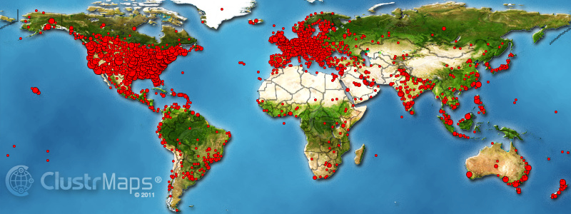
I appended a ClustrMap to Twelve Mile Circle a year ago, yesterday. That’s the little world map image that displays a few boxes down in the right-hand column marked by the “visitor locations” header. The way that the ClustrMap works apparently is that it compiles a map of visitors for an entire year, then it archives the thumbnail image and it starts over again. I managed to captured the larger-sized image on its final day. Behold the locations of a year’s worth of visitors to the website:

I had to compress this a little to fit within the confines of the blog template so feel free to open the image in another window and see it in its original size.
Addressing Concerns
To recap some of my original considerations, I felt the map would be a perfect accompaniment to my geo-oddities blog conceptually. However, I worried about the privacy implications for my visitors. Some of you also agreed with that in email messages to me. So I decided to try it out for awhile without rushing to judgment. Then I could determine whether it posed a problem or not.
Based on the resulting image, I don’t see how it might release any information to potentially track individuals. Hey regular readers, can you distinguish your dot from the others? I can’t find mine. Well, I know the general location but it’s mixed-in with all the others. Maybe you could tell on the first day and then traffic quickly obscures it. Also, the locations aren’t exact and even the smallest of dots cover a fairly wide swath of geography. Well, maybe the guy in the middle of Greenland would have something to worry about, but I think that’s an error in the map anyway. Don’t people in Greenland live only along the coasts? Someone please correct me if I’m wrong.
Results
Not surprisingly, I’ve fairly well covered just about all of North America and Europe. Those areas remind me of the carnival game where one has to shoot a pellet gun at a paper target to cut-out the star. I think I won western Europe (except maybe a tiny spot in Spain?) but I missed a couple of desert locations in Mexico and the United States where nobody lives.
I do a pretty good job around the edge of South America and the Pacific side of Asia. India looks good too. That one actually surprises me. I think I’ve also captured nearly every habitable spot in Australia and I blanket New Zealand. There are vast empty spots like the Amazon and Siberia but it’s hard to expect visitors from lightly populated places. Africa, well Africa has long been my site’s Achilles Heel but I’m improving.
More than all, I enjoyed all the little random islands I’ve captured. Some of them are amazingly obscure.
Thank you all, once again for all of your readership and support.

Leave a Reply