The query simply said, “Most Landlocked State.” It seemed innocent enough as I pondered it. I believed it would have a simple solution. However, the more I considered it the more I figured the answer could vary based upon one’s definition of landlocked. I wish I could ask the anonymous searcher what he (or she) meant but that’s not possible. I’ll throw out a few alternatives and let the Intertubes decide.
At a fundamental level, does he mean “state” as in an independent nation or as part of a larger entity such as one of the fifty United States? If it’s nation then I’d propose Uzbekistan and Liechtenstein. They are both Doubly Landlocked, meaning they are landlocked nations completely surrounded by other landlocked nations. Thus, Uzbekistan and Liechtenstein are probably as good a choice as any.
In the United States

However I’m going to examine the other alternative in a bit more detail by bringing the discussion to the United States. I’m also considering the possibility that states bordering the Great Lakes aren’t truly landlocked: massive ships can navigate a full 2,300 miles (3,700 km) from the Atlantic Ocean to Duluth, Minnesota. Some of the 12MC audience may disagree with that premise and that’s fine. I’m going to run with it.
Given that assumption, there are two U.S. states that are double landlocked: Kansas and Nebraska. Perhaps those are the most landlocked states?
Borderlocking
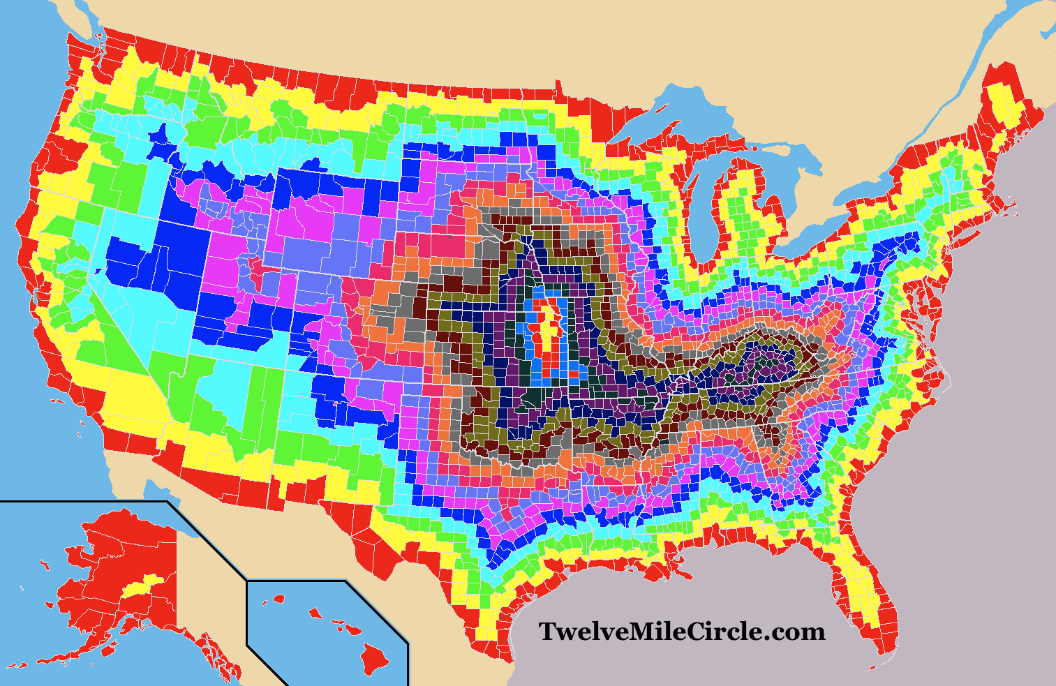
I defined a concept I termed “borderlocking” in an article I posted nearly two years ago: Layers of Borderlocking. It was a similar exercise although I focused my efforts at one level below the states, down at the county level. This created a rather colorful map with seventeen layers of borderlocking. Feel free to go back to the original article if you’d like a better description of what you’re seeing below.

The full seventeen layers happens in a handful of counties in Kansas and in a single county in Nebraska. Interesting. That method also seems to favor Kansas and Nebraska as the most landlocked states, although with a slight nod to Kansas.
Coastlines
One might also consider the point of land within the United States that’s the farthest away from a coastline. That pole of inaccessibility, not only for the USA but for the entirety of North America, falls in southwest South Dakota. One would have to travel 1,030 miles (1,650 km) to reach the nearest coastline from that point.
Now that seems truly landlocked! So is the answer South Dakota?
Another Alternative?
I considered one other possibility. I already allowed an exception for Great Lake states because they’re water accessible. What if I took that concept one step further and defined landlocked as only those places where water could not escape to an ocean (eventually)? Which state has the most acreage within endorheic watersheds?
![Kmusser [CC BY-SA 3.0 (https://creativecommons.org/licenses/by-sa/3.0)], via Wikimedia Commons](https://upload.wikimedia.org/wikipedia/commons/5/56/Greatbasinmap.png)
The Great Basin would be an obvious choice to investigate further. It covers most of Nevada and much of Utah, plus portions of several other states although to considerably lesser degrees. Water falls into the Basin but it doesn’t flow outward, leading to amazing oddities such as the Bonneville Salt Flats that I was lucky enough to visit last summer.
I’d propose Kansas, Nebraska, South Dakota and Nevada as feasible options for the most landlocked state, but I still don’t feel completely comfortable with any of those answers. Are there other ways we can consider this phenomenon and help out our anonymous reader?

Leave a Reply