I went through a bit of an exercise to uncover the extreme eastern and western longitudes for each of the time zones in the Lower-48 United States, in Part 1. These points looked rather striking when I placed them in a map.
Now, let’s look a little closer at the eight points individually. I consider these reasonably accurate but “preliminary” because I did not perform exhaustive searches. I will gladly update this page and provide full credit if anyone finds locations more extreme.
Eastern Time Zone

The easternmost extreme of the Eastern Time Zone is also the easternmost point of the continental United States; West Quoddy Head, Maine. It’s a tourist destination that many people visit and photograph. The actual spot is an otherwise insignificant rock just off the coast but let’s not belabor it. This is close enough for our purpose.
The westernmost extreme gets a bit more interesting and considerably more obscure. The time zone follows the western border of Ontonagon County in Michigan’s Upper Peninsula. The border inexplicably cuts left just as it approaches Lake Superior’s shoreline and the point appears where Ontonagon and Gogebic Counties hit the lakeshore.
Central Time Zone
I think I found the easternmost extreme of the Central Time Zone. It appears to be the eastern extent of Fentress County, Tennessee north of Rugby along the banks of Clear Fork, a tributary of the Big South Fork of the Cumberland River. The boundary comes fairly close to the same longitude as it passes through Florida but I think the spot in Tennessee is a tick further east after checking coordinates through trial-and-error.

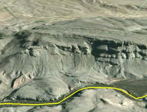
Very few people are likely to visit the westernmost extreme of the Central Time Zone. It’s the point where Hudspeth, Jeff Davis and Presidio Counties in Texas all intersect with the Mexican border. That may sound familiar to long-time 12MC readers: we discussed this point previously in an entirely different context. I created this image using Google Earth for that earlier article. It shows why this will be a difficult place to visit.
Mountain Time Zone
The Mountain Time Zone extends all the way to the easternmost extreme of Dewey County, South Dakota, on the Cheyenne River Indian Reservation. Other points nearby come tantalizingly close to this longitude so it may have a few rivals.
Moving west in Mountain Time, the furthest extreme isn’t a point, rather it’s a line. The zone follows the western edge of Malheur County, Oregon for awhile before cutting directly through the lower portion of the county. The western boundary appears as a straight line from a distance. Drilling in however, one observes minor stair-stepping so that the initial 3-4 mile stretch falls a few hundred feet further west than the rest of the “line.”
A minor Forest Service road happens to traverse the border along this short stretch, and amazingly, Google Street View provides coverage. You may be able to see the county line marker on the left side of the road if you open this in a larger image. Google Maps blurred the words on the sign but even so I don’t believe it mentions the time zone crossing.
Pacific Time Zone
There could be some debate on the easternmost extreme of the Pacific Time Zone, too. It appears to be a line that forms the preponderance of Nevada’s border with Utah and Arizona. Points along Idaho’s panhandle and the farthest reaches of southeastern California rival it though. My quick measurements suggest that they fall slightly short.
The Nevada border isn’t exactly straight. There are tiny jogs, nicks and surveying errors along its entire length. One spot likely extends a tiny amount further east than any of the others but I didn’t have the energy or inclination to find it. I know it’s not West Wendover because that’s the only place in Nevada officially in the Mountain Time Zone. I’ll edit the map if any reader wishes to undertake that mental exercise, but for now I’ll place it on the AZNVUT tripoint for convenience.

The westernmost extreme falls along the Pacific Ocean coastline at Cape Alava, Washington, part of Olympic National Park and the Ozette Indian Reservation. As with its Atlantic counterpart, there are a few rocks and small islands further removed but I’m not going to count them.
Totally Unrelated
Is there any wonder why I’m fixated on the Bibb – Monroe County dispute in Georgia? Now it involves restraining orders! [link no longer works]. This one keeps getting better and better.

Leave a Reply