I encountered a number of interesting situations as I pulled together my recent series of borderlocking articles. One of those revelations pertained to Jeff Davis County(1) in the State of Texas. Examine its layout closely. Clearly it borders on Mexico. However that happens only at a single point along the Rio Grande River at its western extreme. I searched the maps to determine if this situation existed anywhere else in the United States. Nonetheless, I could not find a single additional instance. I believe this may be the only example in the United States where a county contains a single-point international boundary.
This county outline map demonstrates the general situation in question. Jeff Davis County forms roughly a diamond shape turned on its side. There it anchors the remainder of sparsely populated counties of farthest West Texas.
So Jeff Davis’ gain is Culberson County’s loss. Culberson is Jeff Davis’ northern neighbor.
Culberson fails to reach the Mexican border by only a few miles due to the triangular layout of Jeff Davis, Hudspeth and Presido Counties at this remote intersection.
Why This Single Point?
One wonders what must be so vital at this point along the Mexican border. What justifies an extension of Jeff Davis County all the way to the waters of the Rio Grande?
I’ve driven through Jeff Davis County before. This happened as I traveled between Big Bend National Park and Carlsbad Caverns quite a few years ago. It’s desolate and empty, magnificent and beautiful in a haunting way. So these were county lines probably drawn in a back room through the give-and-take of negotiation.
The process ignored the realism of underlying topography, of that I feel nearly certain. Long, straight lines made sense out here where few people live even today. It’s easier to fix a point on a recognizable topographic feature, a river in this instance. I doubt it included any more significance than that. I’m sure those thoughts went through the founders’ minds when they formed the county in 1871. I never found any evidence to the contrary.
At the Spot

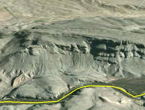
Google Earth demonstrated another fascinating feature. I grabbed this screen image from Google Earth with the 3D toggle activated. Then I applied sufficient tilt to activate the underlying topography. This view faces nearly due East, flying in from the Mexican state of Chihuahua (not to be confused with the dog of the same name). It looks directly into Texas.
The yellow line marks the Rio Grande, the border between Mexico and the United States. Notice the pale green lines descending from the upper-left and upper-right corners and converging at the Rio Grand. Those are county lines. Thus, Mexico is the foreground, Hudspeth County is the left triangle, Jeff Davis is the middle triangle and Presidio is the right triangle.
Getting There on Foot
I’m not sure anyone could reasonably travel directly to the shared border between Jeff Davis County and Mexico without leaving Jeff Davis. Notice the large escarpment that stands within its path. Naturally I consulted a U.S. Geological Survey topographic map to check it out. The elevation changes from 3,800 feet to 3,236 feet over a short distance. So the bluff drops nearly 600 vertical feet almost instantaneously.
It might be feasible to approach the point from either of the adjoining counties. Poke around any of the satellite images and one will find a number of farm roads leading towards the river. They’re a mile-or-two removed from either side of the point, allowing one to circumvent the escarpment at least theoretically. However, it’s not clear to me whether one could hike along the U.S. bank of the Rio Grande to get there. The land seems rather rugged.
Another Alternative
Officials might consider trekkers using a boat as a border incursion. At the very least it would require a passport. I guess it could also involve a lot of explaining. What if officials on either side of the line spotted our intrepid waypointer in transit? I can just imagine someone trying this explanation with a representative of the US Customs and Border Protection agency: “Seriously, I’m trying to reach the only location in the United States where a country intersects with an international border at a single point”. Somehow I don’t see that one going over very well. That’s nothing compared to what would happen if someone ran into a smuggler in these remote hills. That’s probably the more likely and terrifying scenario. I can’t imagine it ending well.
Nonetheless, if you’re feeling adventurous and want to be the Indiana Jones of odd-geography, go ahead and set your GPS for 30.629097, -104.979983. Give it a go and report back to us!
12MC Loves Footnotes!
(1) Yes, it’s named after that Jeff Davis, a.k.a., Jefferson Davis, the only President of the Confederate States of America, 1861-1865. I mention that in consideration of the tone-deaf governor of my beloved Commonwealth of Virginia who declared April 2010 to be “Confederate History Month.”

Leave a Reply