I noticed a claim on the Intertubes, primarily because someone using a search engine landed on Twelve Mile Circle seeking more information. It asserted that one can travel due south from Missouri to enter each state that borders it. That doesn’t seem logical so that’s why the claim attracts attention.
Missouri and Tennessee are the only states that share a border with eight other states. No state has nine or more adjacent neighbors. So it would seem to be quite an accomplishment if I could prove the claim. One needs to examine a map where Missouri touches Iowa, Illinois, Kentucky, Tennessee, Arkansas, Oklahoma, Kansas and Nebraska. That shouldn’t be too difficult.
The Easy Ones
Lets mention the obvious one first. Arkansas requires little thought because it hugs Missouri’s southern border for most of its length. Let’s move on.
The slight-of-hand that allows one to travel south from Missouri into various neighboring states exists because portions of its border follows rivers; the Missouri River on the west side and the Mississippi River & Des Moines River on the east. Select any of the linked state names to view a Google Maps page of an example: Iowa, Illinois, Kentucky, Tennessee, Kansas and Nebraska. One might need a helicopter or a boat to accomplish this feat, but it would be possible to travel due south from Missouri into each of those states from at least one point.
Then Oklahoma
Oklahoma seems to be the troublemaker. The border appears to be completely straight, seemingly following an exact line of longitude and thus making it appear impossible to cross south from Missouri into Oklahoma. However, as we’ve observed many times on 12MC, quite often one can find tiny anomalies and surveying corrections in what seems to be a straight-as-an-arrow border. Such is the case here, too.
I noticed a small tick in the border between the two states. It’s south of Interstate 44 and just north of E. 40 Road using Google Maps. I believe this is a Google Maps error based on further research. The 2000 version of the Newton County, MO plat book, the place where the alleged border jog is located, does not show this anomaly [link no longer available]. So much for the most obvious opportunity to prove the point.
Undeterred, I pressed onward with a better result.
This minuscule boundary adjustment, no more than about 75-100 feet wide, sits a couple of miles north of Seneca, Missouri where Oklahoma’s E. 94 Road hits the border. This is not a Google Maps error. It shows up on the 2000 Newton County plat book too. Thus, in at least one very small location, it is indeed quite possible to travel due south from Missouri and enter Oklahoma (on foot no less). The Internet claim is true.
More Weirdness
As an aside, one uncovers an interesting phenomenon as one searches on terms like “anomaly Oklahoma Missouri border.” I didn’t find any border jogs using this method — I had to squint at a bunch of maps instead — but it does bring up what’s known as the Hornet Spook Light or the Devil’s Promenade. It’s ascribed to lots of paranormal and other-worldly causes although it seems to have a a more mundane explanation.
People who have had close encounters with the light describe it as being anywhere between the size of a baseball and a basketball or larger. It can be almost any colour, and may change colours or have multiple elements, but is most frequently described as orange or yellow… The area has been studied many times, including most famously by the US Army Corps of Engineers in 1942, who concluded that the phenomenon was due to the refraction of distant headlamps on Route 66…
The border jog that allows one to travel south from Missouri to Oklahoma sits directly within prime Hornet Spook Light territory. It holds significant promise as a premium twofer geo-oddity adventure for those in the area searching for such things.
Let’s Try This With Tennessee
Did the small Missouri-Oklahoma boundary connection feel a bit bogus to you? It did to me. Technically it is correct although I wonder if perhaps our unknown searcher was confusing Missouri with the other 8-neighbor state? Tennessee also allows one to travel south into all of its neighbors, and more elegantly: Kentucky, Virginia; North Carolina; Georgia; Alabama; Mississippi; Arkansas and Missouri.
Come to think of it, I imagine one could pick just about any state and any cardinal direction and replicate this feat thanks to small surveying errors and corrections. It might be fun to try this trick with more challenging rules, such as one must be able to drive, not hike, fly or float.
Totally Unrelated
Just go ahead and close this page unless you enjoy immature potty humor.

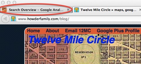
Apologies in advance, but I couldn’t help notice the very unfortunate way my browser truncated the Google Analytics tab. This would have to be the worst, most invasive Google tool ever developed. I don’t want to know what the Search Overview of Google Anal would involve, however, I imagine the Transportation Security Administration (TSA) may want to investigate it for airport check-in lines.

Leave a Reply