Colin, a reader from South Hedland in Western Australia, sensed my dismay with the long distance displayed on a particular Texas road sign. He offered to share some extreme examples from his homeland.(1) My sign noted that El Paso, on the other side of the state, was 857 miles (1,380 kilometres) away. That’s pretty good but prepare to be amazed with some Australian road signs from Colin’s collection.
Carnarvon – Mullewa Road
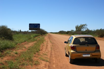
So let’s start at the town of Carnarvon on the western coast where the Gascoyne River meets the Indian Ocean. I enjoyed this image in particular. It shows the type of road that vehicles must cover on many sections of this sparsely-populated terrain. Namely dirt.

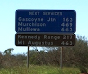
Colin mentioned that the road is sealed (paved) for about 100 km after this point. However, it reverts back to dirt for the next 500 km or so. Imagine riding over 500 km of dirt at a speed of probably 90 km/hour. The sign in the distance is a bit illegible because I had to reduce the size of the photo to fit into the blog, so here is a close-up:

The furthest distance listed is Mullewa at 663 km (412 mi). That’s still less than the Texas road sign. But let’s remember that this is largely a dirt track for several hundred kilometres. It’s nothing like the high-speed interstate highway that rips across the width of Texas.
I’ve reproduced the track implied by the road sign, above. Notice that it’s merely a tiny segment of road within a single Australian state. Things are about the get much more incredible.
Eyre Highway
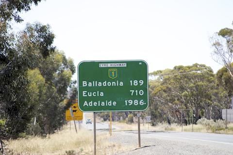
I’ve expressed my fascination with the Eyre Highway a couple of times previously on Twelve Mile Circle. The vast distances and rugged isolation along the Nullarbor Plain inspired both a weird unofficial time zone and a so-called world’s longest golf course. The road sign located here blows the Texas example right out of the water.

Indeed, from this spot in Norseman, Western Australia (loved the camels in the roundabout by the way) to Adelaide, South Australia, a traveler will need to cover 1,986 km (1,234 mi) along a contiguous road! True, the route does not remain within a single state as is the case with Texas. Nonetheless, I find the sheer audacity and enormity of the distance quite impressive.
Gunbarrel Highway
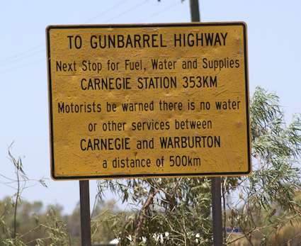
The next sign cuts to the heart of the difference between the Australian concept of distance and its Texan cousin. Ponder the significance of this sign posted near an entrance to the Gunbarrel Highway.

The Texas sign is a boast, proudly taunting arriving motorists that they’ve arrived at something bigger. They didn’t post it to be helpful but to brag. Conversely, the Australian signs are a warning. Drivers must depend upon themselves and their own resources to cover long distances between available services. So, “Motorists be warned that there is no water or other services between Carnegie and Warburton a distance of 500 km.”
The message is unmistakable. Break down along these stretches and a driver may be in serious trouble. It could even be fatal.
Thanks for the input, Colin!
12MC Loves Footnotes!
(1) Some of the best story ideas come from user suggestions and content. In addition to Colin’s contribution, I’d recommend user content provided in The Triple Frontier Lost Again, and Counting Border Crossings.

Leave a Reply