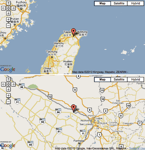
It’s odd that I keep getting random search engine hits on the phrase, “closest antipodal national capitals” when I’ve never covered the topic on Twelve Mile Circle. Meanwhile, several other websites have covered it rather extensively. The whole topic of antipodes in general seems to receive an inordinate amount of attention. I found a series of other useless fascinating facts as I researched this further.
The antipode of a place on earth is its exact opposite, drawing a line straight through the middle of the earth. As a child I thought I could dig to China if I dug a hole deep enough. I got about two feet down before I gave up. Of course I learned soon enough that I would never hit China even if that were possible. Then I worried that I might dig down and flood my home with the Indian Ocean. Oh, the joys of childhood.
The two national capitals closest to being antipodes are Asunción, Paraguay and Taipei, Taiwan. Either one is only 53 miles (86 kilometres) from the antipode of the other, as reported in a 2001 discussion on The Math Forum. [link no loner available].
My Examination
I examined this with a rather brute-force method, a tool available on the Antipodes Map website. I had a lot of fun generating maps like the one featured in this screen shot.

A More Precise Examination
The author on The Math Forum took a much more sophisticated approach. He used great circle calculations that considered Earth’s oblateness as well as more traditional antipodal calculations (i.e., based on lat/long coordinates). Ultimately, he found little difference in the basic order of the closest antipodal capitals using either method.
- Asunción, Paraguay – Taipei, Taiwan, 86km
- Madrid, Spain – Wellington, New Zealand, 159km
- Bogotá, Colombia – Jakarta, Indonesia, 194km
Additionally he identified other possibilities that might figure into the mix depending on how one defined “capital,”
- Adamstown, Pitcairn Islands – Manama, Bahrain, 143km
- Adamstown, Pitcairn Islands – Doha, Qatar, 164km
- Mata-Utu, Wallis and Futuna – Niamey, Niger, 184km
I think I’d discard the second set. The Pitcairn Islands are a British Overseas Territory. Wallis and Futuna is an overseas territory of France. Neither is a sovereign nation. However, I decided to list them here anyway because they’re still remarkable in a sense.
Other Interesting Antipodes
I wish I could take credit for finding these but in fact they’re widely available on many different websites. I’ll provide links for those sites I that I thought were particularly well done.
Formosa
Taiwan used to be called Formosa. The antipode for one small corner of the island falls in Argentina, in the province of Formosa. It appears to be coincidental. Taiwan’s former identification came from Portuguese explorers while Argentina’s came from Spanish sailors.
Nonetheless, Formosa derives from “beautiful” in the 16th Century parlance of both languages. There are plenty of beautiful places on earth and that’s why I think it’s probably just an interesting coincidence.
Mecca
There seems to be a nearly endless discussion on the Intertubes about Mecca’s antipode. Theoretically someone with a ship and a little determination could sail to the antipode, and pray towards Mecca legitimately in any direction. The EVS-Islands Blog, “Thoughts – Antipode of Qibla at Mecca and the Antipode of Tematangi Atoll FP” discussed this possibility particularly well.
Colorado
Very little of the Lower 48 United States contains dry land antipodes. This includes two tiny spots in Colorado. The US Highway Endpoints website features the Colorado Land Antipodes along with a couple of great interactive Google Maps that they’ve customized for this specific purpose.

Leave a Reply