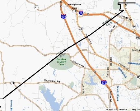
I don’t know what’s going on in the minds of the citizenry of the State of Georgia. They just don’t seem comfortable within their borders lately. They’ve been tugging, pulling, cinching and stretching their ill-fitting suit, maybe hoping to address some ancient wrongs or remove old annoyances. Certainly, plenty of opportunities exist. They’ve had the same basic shape since 1802 when they ceded their western claim.
Last summer a legislator in Georgia wanted to redraw the border with Tennessee. This would have provided access to Nickajack Lake, a large water reservoir near Chattanooga and help them weather a protracted drought.
Now, only a few months later, an ongoing county-level squabble verges on nasty as an endgame approaches. Welcome to the Bibb–Monroe Border War.

Examining the Past
We need to look back a couple of hundred years when it could have been so straightforward. According to a 1941 article in the Monroe Advertiser [link no longer works] the Georgia General Assembly established a firm, straight border in 1822 when it created Bibb county. It followed a direct line between Torrentine’s Ferry on the Ocmulgee River and the northeast corner of Crawford County.
The deficiencies of early 19th Century surveying have been discussed several times on Twelve Mile Circle. And a similar situation exists in this location. The portion of the supposedly “straight” border appears a bit wobbly. Also, Torrentine’s Ferry went out of service a long time ago. Even back in 1941 the experts could only guess at its possible location by examining foliage patterns along the riverbank.
On top of that, take a look at the jog at its northeastern terminus. In 1877 a local doctor, Lee Holt, decided he wanted to live in Bibb County. He actually persuaded the General Assembly to change the boundary! In fairness to him, he owned all of the land between his residence and the river. The change didn’t impact anyone else, but still, that seems to be a remarkable adjustment for the convenience of a single person. Today, however, it does have an impact. The legislation specified only that the residence of Dr. Holt should be incorporated within Bibb County. The definition of “residence” now becomes a point of contention.
A New Survey
What a mess. In response, the the Governor commissioned a boundary survey recently. Bibb County houses many times more people, about 150,000 including the City of Macon. Monroe County features much lower density with about 25,000 inhabitants. The problem includes subtext of rural versus urban lifestyles, interwoven with downstream factors such as tax rates, school systems, crime statistics and basic government services.
Granite survey markers began springing up within the last few days. They seemed to suggest that Monroe County would gain territory, even though a final decision has not been made. This caused quite a ruckus.
Local Reactions
I could spend a great deal of time outlining them but frankly much better sources discuss the issues from a local perspective:
[UPDATE: unfortunately, with the passage of time, these links no longer exist].
From WMAZ 13, the Macon CBS television station:
- Survey Could Shift Monroe-Bibb Line (January 2) – Provides a good overview and includes photos of a provisional boundary marker.
From a blog called WMCC News that has been doing a great job of covering developments in real time:
- Border War (January 3). Includes several border markers uncovered by the author and an interactive Google map; excellent investigative reporting (I could have embedded his map here, but honestly, you should really check out this post and the others).
- Border War, Chapter 2: Who’s in and who’s out? (January 4). Be sure to examine the whole set of comprehensive maps that show the potential impact.
- Border War, Chapter 3: Are You a Monroe-ian or a Bibb-ite (January 5). The source of that 1941 article I referenced above.
- Border War 4: Meet Tommy Torrentine (January 5). An amusing fictional interview with the ferry operator set in 1820.
Comments posted by various readers in response to the blog entries are both instructive in terms of understanding all sides of the issue as well as being entertaining in their own right.
Implication
If you think this just inconveniences a few people who might now find themselves in a new county, you would be mistaken. A Bass Pro Shop sits right along the border, currently in Bibb County. It’s not just any Bass Pro Shop, but a 500,000 square foot distribution center that serves the entire southeastern United States along with a 125,000 square foot retail store and 1,000 jobs. The proposed border cuts right through the facility with the promise of large tax revenues for Monroe County should the revised boundary stand.

Leave a Reply