I noticed an interesting theme in a small town in Eastland County, Texas. Carbon, population 224, seems dedicated to all things carbon as befitting its name. Check out its fascinating array of streets featuring carbon in various allotropes, primarily although not exclusively in the form of coal and its derivatives.
Carbon-themed streets I found:
- Coal
- Anthracite (a variety of coal)
- Asphalt (tar comes from coal, but modern asphalt comes from petroleum products)
- Cannel (a variety of coal, sometimes also called candle coal)
- Coke (a coal-based substance used in smelting iron ore)
- Diamond (also carbon)
- Jet (wood decayed under intense carbonic compression. I’ve heard items described as “jet black” my entire life but I’ve never bothered to check what jet was until a few moments ago)
- Lignite (a soft brown coal)
… and Lover’s Lane? I have no idea how the town founders let that nonconformist outlier find its way onto the map.
I should also note that Carbon is only a few miles from Nimrod on a Farm-to-Market Road. Indeed, it’s a banner day for interrelated geo-oddities. I may have to pinch myself to make sure it’s true.
Coal in Texas
That odd conglomeration would lead one to believe that coal mining must have been common in Texas at one time, and indeed that was the case. The Texas State Historical Association’s Handbook of Texas Online notes that the state “has an appreciable quantity of low to medium grade bituminous coal and a large quantity of average to high grade lignite.” Furthermore, “in the period from 1895 to 1943, Texas mines produced more than twenty-five million tons of coal.”
The industry took a back-seat to oil, a commodity more commonly associated with Texas, although even in the 1990’s, “Texas was the nation’s sixth leading coal producing state.”

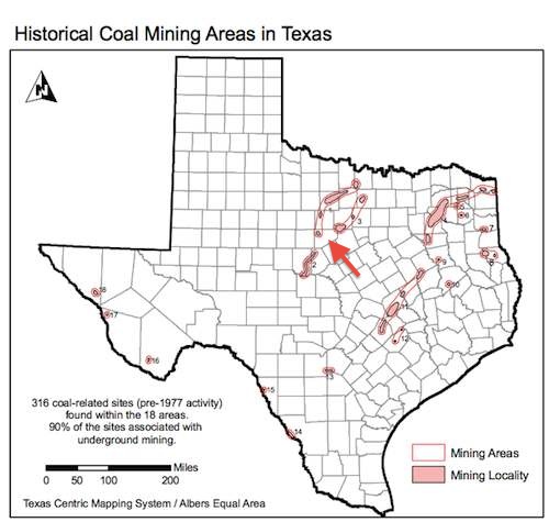
Concentrations of Pennsylvanian bituminous coal surrounds the town of Carbon, marked with an arrow on this map, on three sides. Mining activity commenced in those regions during the same time period as the town arose, circa the 1880’s.
Thurber

One thinks of Appalachia when hearing of a company town adjacent to a coal mine, but there was one of those nearby too. The town of Thurber, or more appropriately the ghost town of Thurber, is located about thirty-five miles northeast of Carbon (map).
The Texas and Pacific Railroad needed coal to run its engines. Luckily they found a convenient source available right near its rail line. They formed a coal company, purchased the coalfields from the original owners and began to extract coal in 1888. According to the W.K. Gordon Center at Tarleton State University:
“In order to control the work force in the mines, the Texas and Pacific Coal Company fenced off its property at Thurber and constructed an entire community for its workers with ‘schools, churches, saloons, stores, houses, an opera house seating over 650, a hotel, an ice and electric plant, and the only library in the county.’ The company then began hiring miners on its own terms, excluding union activists. Because of the relative isolation of the Thurber mines, the company recruited workers from great distances. Though a large percentage of miners came from Italy, Poland, Britain, and Ireland, eighteen nationalities were represented at Thurber.”
The Thurber site eventually unionized but oil began to replace coal on the railroads and elsewhere. Thurber once served as a home for several thousand residents but it went into decline rather quickly. It was all but abandoned by the time of the Great Depression. Thurber is largely gone today although its smokestack still stands. It is perhaps also worth noting that a county line runs directly through the cemetery. Select the correct plot and it’s possible for someone to be buried in Palo Pinto and Erath Counties simultaneously.

Leave a Reply