Do you notice anything remarkable about this little patch? It seems like this must be the middle of nowhere, just a sea of red soil and desert scrub removed from any hospitable place. However, according to some calculations, this is the centre of Australia.
Am I the last one on the planet to know that there isn’t an “official” way to calculate the centre of a geographical unit? In my wanderings I’ve seen references and sometimes formal markers dedicated to the centre of such-and-such city, town or county. I feel like I’ve been duped. Here we have Australia, an entire continent no less, and a whole bunch of different centres can be calculated. Each one is as legitimate as the other.
Calculating the Centre
I always thought the centre was calculated by imagining a cut-out of the area and seeing where it would balance on the tip of a pin. That’s indeed one common method. Here are some other possibilities:
- Draw a box that exactly touches an area’s extreme latitudes and longitudes, then draw an X between the opposite corners. The middle of the X is the median point. I use a variation of this method when I’m embedding Google Maps in my web pages (e.g., Ferries of Australia). It’s a simple mathematical calculation that works great for that purpose.
- Draw the smallest perfect circle that completely surrounds the object. Use the middle.
- Find the place that is the furthest away from any coastline.
- Cut-out an image, pick it up at a point along the coastline and hold it vertically. Then use a plumb line to draw a line through the object. Pick another point along the coastline and do it again. Select the spot where the lines converge.
There are variations and levels of sophistication. Curvature of the earth might be one consideration. Using the high tide mark as the definition of “coastline” might be another. Answers may also vary depending on how or whether one incorporates territorial islands.
Thus, any claims to being the centre of anything on a landmass would be somewhat bogus, more entertainment than science. Also, let’s not discount the tourism factor — anything to bring outside money to an otherwise nondescript location. That’s OK. Twelve Mile Circle is all about oddities, dubious or otherwise.
Applied to Australia
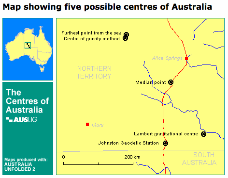
Here’s what will happen if one places the results of various methods upon the Australian landmass.

All of the points are fairly close to Alice Springs and Uluru (Ayers Rock). Each of these methods produces a result not too dissimilar from the others but there’s a definite spread. We still have lots of room for debate and disagreement.
Consider going to the Geoscience Australia page and see diagrams of various methods as well as centre calculations for each of the states and territories. I’ve really enjoy that page.
Nonetheless, one of the measurements gets a lot more attention on the ground than the others.
A Remarkable Marker
The Royal Geographical Society of Australia undertook the ultimate calculation and marked the most precise spot as part of the 1988 Bicentennial celebration. They used a centre of gravity method consisting of 24,500 coastal points measured at the high water mark. They named their result the Lambert gravitational centre to honour a former director of national mapping.

The marker can be visited as part of a day-trip from Alice Springs. The drive looks a little challenging, but seemingly feasible with any vehicle designed for off road usage. It’s quite a remarkable monument given its remoteness.
Who would go out of their way to visit such a remote marker of such questionable significance? Well, someone like me naturally. I’d love to visit that spot if I ever had an opportunity. I imagine a number of you would too. I guess I’ll put this one on my list of future travel adventures.
Lastly, I’ll leave you with this groaner from a Geoscience Australia press release (and don’t say I didn’t warn you): “So where is the dead centre [of Australia]? It’s the local cemetery!”

Leave a Reply