Counting Border Crossings

I’m a relentless counter. I count lighthouse, ferries, waterfalls, breweries and even nineteenth century coastal fortifications during my travels. I used to count states but it became pointless when I reached all fifty so I switched to counties. Last summer I hit my 1,000th county and I’ve continued onward from there. If it’s possible to count something then I’m probably already counting it. Or so I thought.


A New Way to Count

That’s why I was a bit surprised when loyal reader Jon Persky suggested a new way to count. It should have been intuitively obvious to me but somehow I’d overlooked it all these years. He collects each state border crossing. Thus, he examines each possible combination of crossings between adjoining states. For example, and let’s use an easy one, if one were to “complete” Florida, one would have to cross its borders with Georgia and Alabama.

Jon adds a little twist to this game. He also includes any possible combination of border crossing between each of the U.S. states and individual Canadian provinces and Mexican states. So if one were to complete Vermont under these rules, a traveler would need to cross its borders with New Hampshire, Massachusetts, New York and Québec.

See how the game works? We could apply the same counting method to any secondary units of government in any country. Whether one wanted to play this with counties of Ireland, départements of France, states or territories of Australia, or whatever, we could calculate and track them. Additionally we could transfer the rules easily enough to an international setting. To complete Luxembourg, for example, one would need to cross its individual borders with France, Belgium and Germany. I’ve actually done this one!.

This game is insidiously difficult even thought it has such basic rules and seems so easy on its surface. Simply clipping a territory doesn’t generate much progress. Admittedly it adds a single crossing to the total but players have to cover large distances to complete even the smallest of states because the object is to work the perimeter.


An Underlying Map

Jon put together a map for the United States with individual state crossings, including those with Canadian provinces and Mexican states. He believes the total comes out to 138. I could count them myself on his map or I could take his word for it. Well, I’m generally lazy so I’ll trust him.
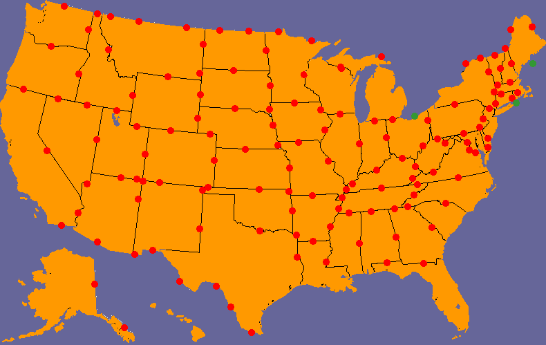
Possible Border Crossings between U.S. States

The red dots are land or bridge crossings and the green dots are direct ferry links. Notice that via ferry one can cross between New York and Rhode Island (Long Island to Block Island), Ohio and Ontario (Sandusky to Pelee Island) and between Maine and Nova Scotia (Portland or Bar Harbor to Yarmouth). Don’t get too hung up on the exact placement of the dots. They’re simply intended to signify that a crossing is possible between adjacent geographical entities. It does not imply that this is the exact place where a traveler must cross.

I’ve shrunk this image down to fit within the borders of the blog. However it should download to its larger size if you want to use this for your own personal tracking purposes.


My Results

So how did I do? Better than I expected since I’ve never counted my travels this way before, but pretty lousy overall. I’ve done about half the possible crossings.

I’ve marked my progress with black dots on the map below. Well, I think the total comes out to about 75. It looks like I’ve completed only 6 states though (and a couple more if I don’t count Canada). I’ll have to take a closer look and ponder this some more.
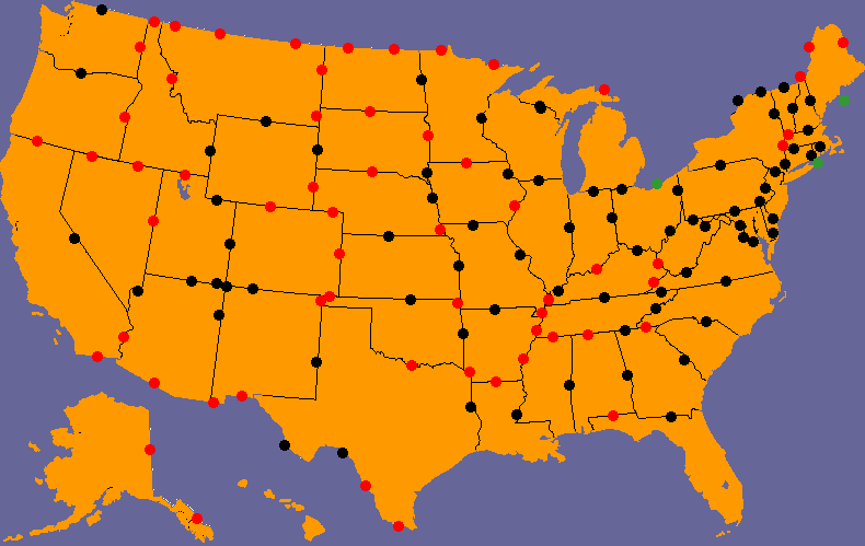
Personal Border Crossings between U.S. States

I haven’t even completed my own home state of Virginia where I’m missing its border crossing with Kentucky. Unfortunately, I doubt that I’m going to get this one anytime soon. [UPDATE: I crossed Virginia – Kentucky in 2013].

However, now that I’m aware of this method of counting I’ll follow it more closely. Had I been thinking about this last summer I could have snagged Iowa to Illinois with little difficulty. Oh well. Now I have another hobby.

Jon also provided me with a list of every possible crossing between individual counties found within each of the states. The total comes out to an amazing 9,229 possible border crossing possibilities. That should satisfy anyone’s need to count for a lifetime. Please contact me directly if you would like a copy. I think that list goes beyond even my relentless need to count!


Posted

in

, , , ,

by

Comments

16 responses to “Counting Border Crossings”

  1. Dipesh Avatar
    Dipesh

    Love the blog…as a lover of geopolitical oddities, your blog is one of my favourites.

    There’s two ferry crossings between Wisconsin and Michigan. Milwaukee to Muskegon and Manitowoc to Ludington…

    1. Twelve Mile Circle Avatar

      Thanks, Dipesh. I’ve been fortunate enough to take the crossing between Manitowoc and Ludington before (here’s my travel page on the subject) — the most memorable part for me was discovering that Lake Michigan is so large that one completely loses sight of land in every direction during the crossing. It’s more like the open sea than a lake. I’d recommend that journey to all who happen to find themselves in that neck of the woods. It’s truly amazing and avoids all the Chicago traffic as an added bonus. The easier although less romantic way to cross between Wisconsin and Michigan is the land border between northern Wisconsin and Michigan’s Upper Peninsula. I’ve done that one too. 🙂

      1. Jeff Rundell Avatar
        Jeff Rundell

        The width of Lake Michigan reminds me of a story of a French priest who traveled west across Michigan. When he came to the lake, he asked the local Indians what the people on the other were like, and was told “They are quite different from us, very strange”. So before he asked the locals to ferry him across, he brushed up on his Chinese!

  2. Jon P Avatar
    Jon P

    Thanks for the shout-out Tom! Now for the second-guessing. I realize belatedly that Arizona and Baja California share a border along the Colorado River. Flying over the area on Google shows no (legal) way to cross, so it doesn’t deserve a dot.

  3. Jen R. Avatar
    Jen R.

    What a cool new way to count! I especially like Jon’s inclusion of wet border crossings, such as New York-Rhode Island. I would venture one step further in not privileging land over water: one cannot “complete” my home state of New Jersey or any other coastal state without dipping one’s feet into the ocean/sea/gulf.

  4. Richard Avatar
    Richard

    Actually, I think you need to take one of the ferry crossings off the map. According to both Wikipedia and http://www.blockisland.com/directory.html#Accommodations, Block Island is part of Rhode Island, not New York. Google Maps doesn’t display any ferry crossings between, say, RI and Long Island, although I don’t know how complete that data is.

    1. Twelve Mile Circle Avatar

      Correct — Block Island is definitely part of Rhode Island. As I noted above, "one can cross between New York and Rhode Island (Long Island to Block Island)." The departure point in New York on Long Island is Montauk. Viking Fleet offers a high-speed ferry from Montauk, NY to Block Island, RI on a seasonal basis so it’s possible to cross between New York and Rhode Island except during winter.

  5. Jon P. Avatar
    Jon P.

    One more “wet” crossing I forgot to put on the map: Grand Portage, MN to Isle Royale National Park, MI: http://www.isleroyaleboats.com/

  6. pfly Avatar
    pfly

    There are at least 7 or 8 land crossings between Washington and British Columbia, and at least 3 ferry crossings (Anacortes to Sidney, Seattle to Victoria, Port Angeles to Victoria). There’s also at least 3 crossings between New York and Ontario over the Niagara River alone. Looks like you have your work cut out for you! I quite enjoy your blog. pfly

  7. pfly Avatar
    pfly

    Oh wait, is this just counting all state to state/province crossings in one go? So just one for all Washington-BC and NY-Ontario crossings? Ok, that’s much easier! In that case, I don’t think you can cross from Idaho into British Columbia.

    1. Twelve Mile Circle Avatar

      There seem to be a couple of roads across the border between Idaho and British Columbia. Unfortunately it’s the part of the border Google leaves somewhat blurry, I guess for security reasons, so it’s hard to tell, but it looks like they go through:

      Anyone out there have any experience with either of those crossings?

      1. Tom R Avatar
        Tom R

        I’ve made both of the Idaho to BC crossings, at Eastport many times. Eastport is fairly important, being the main freight crossing from Calgary and the Alberta oil fields to Spokane and on to California, or to Washington and Oregon ports via US freeways. There’s both train and trucks crossing at Eastport.

  8. pfly Avatar

    Doh, my bad. I should learn not to read blogs and comment when I should be sleeping. I was thinking of the Priest Lake part of Idaho, where the road north does end (I think!). I forgot how much stuff they cram into that narrow panhandle.

    (PS, I finally started my own geographic blog, Toponymia, perhaps to focus on place names and such like. Only just started but thought you might like at least the creek vs. brook map)

  9. Anton Sherwood Avatar

    What’s with the two extra dots at Four Corners?

    1. Twelve Mile Circle Avatar

      That’s to show the diagonal crossings between Arizona-Colorado and Utah-New Mexico. It’s a product of the busyness of the map that occurs at the 4 Corners.

  10. Craig Avatar
    Craig

    For ferry crossings, you seem to have forgotten NY/CT (either Port Jefferson/Bridgeport or Orient/New London).

Leave a Reply

Your email address will not be published. Required fields are marked *

Latest Comments

  1. Osage Orange trees are fairly common in Northern Delaware. I assumed they were native plants. As kids we definitely called…

  2. Enough of them in Northern Delaware that they don’t stand out at all until the fruit drops in the fall.…

  3. That was its original range before people spread it all around. Now it’s in lots of different places, including Oklahoma.