Counting Down

Most comments on Twelve Mile Circle are made to articles written recently, primarily to those posted within the past few days. That doesn’t prevent readers from commenting on older articles though. I leave the comment window open indefinitely. People wander their way to the site however they manage to do it, and I assume most of them arrive using Google or some other intertubes search engine, and leave their digital impressions behind.

Comments then have to be moderated to separate content from spam so I read every single one of them. Sometimes that process leads me to reexamine articles written several years ago either from a nostalgic perspective or with a fresh new set of assumptions.


Revisiting Kalawao

Kalaupapa and Kalawao Settlements. Photo by NPS CulturalLandscapes; (CC BY-NC 2.0)
Kalaupapa and Kalawao Settlements

A recent comment applied to one of the most ancient of all 12MC articles, Smallest County in the USA, Part 1, written in February 2008 when the site was only three months old. The reader’s observation dealt with the conundrum of whether to count a visit to a physical location or not, in this case the county of Kalawao in Hawaii.

“I also stood on top of the cliffs at the border. But I refused to pay a fee and a day of my time to set foot on it. And the rest of Moloka’i was way more worth my very limited time….. So, did I visit Kalawao county?”

That wasn’t a new discussion to 12MC. We all delved into similar peculiarities a couple of times in articles that generated lengthy discussions back in 2011, chiefly I’ve Barely Been There and It Counts but it’s Pitiful. I had my own criteria that I continue to follow. Others have theirs, equally valid. An international association doesn’t exist to publish a rule book and nobody gets sanctioned for straying across a line. It’s all good.


Running Changes

However those two articles led me down a different path as I reviewed what I wrote back then. It dawned on me that none of the examples I used to make my point back then were any good any more. My county counting map looks considerably different nowadays.
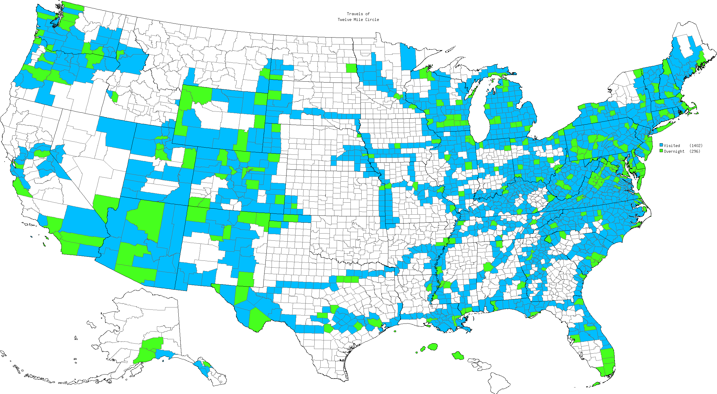
Counties in the United States that I have Visited
This map will always update as I visit new counties

I’d highlighted my particularly pitiful efforts in four U.S. states in the first article: Montana; Oklahoma; Arkansas and Rhode Island. The situation changed dramatically over the years.

Montana State Line. Photo by howderfamily.com; (CC BY-NC-SA 2.0)
Entering Montana in 2015

Oddly enough my efforts were aided and abetted by adventures related to running. The first three were specific stopping points for different Mainly Marathons events, specifically their Center of the Nation (Montana), Dust Bowl (Oklahoma) and Riverboat (Arkansas) series of races.

Rhode Island was an offshoot from a different running organization called Ragnar, specifically Ragnar Cape Cod, a relay race stretching from Hull to Provincetown, Massachusetts. Rhode Island was just around the corner so why not stay a little longer and stop for a visit? I’m not a runner nor will I ever pretend to be one. I simply chauffeured a runner from site-to-site (or as I like to call it, “Driving Miss Daisy“) and I managed to see a bunch of places I’d never had any reason to visit before. With that, I felt confident in the legitimacy of my trips to each of those four states.


Venturing Beyond the Airport

Graceland in Memphis, Tennessee. Photo by howderfamily.com; (CC BY-NC-SA 2.0)
A more proper visit to Memphis: Graceland

This left the second article dealing with airport-only visits. I connected Shelby County, Tennessee (Memphis Airport) to my larger grid thanks to the aforementioned Riverboat race series. Similarly, I spent a week in northern Utah that brought the formerly stranded Salt Lake County (Salt Lake City airport) into the fold of my larger efforts.

Finally I erased the embarrassment of my airport-only (Shannon) visit to Ireland. I spent a couple of weeks covering a wide swath of Ireland in the summer of 2014.

I continue to stand by my old rules although I don’t really have any airport-only counties, states or nations remaining anymore. The closest I come to that might be Dallas, Texas and Boise, Idaho. I both cases, however, I’ve made multiple trips lasting days and certainly left the confines of the airports to conduct business. I’ve not yet connected them to the larger overland grid so they stand out like little islands though. [UPDATE: I connected Dallas during my cross country trip in Dec. 2018 / Jan. 2019]

I need to think about the next set of adventures over the winter and consider where to focus my energies next. Connecting dots? Filling doughnut holes? Drawing lines over the Great Plains? All nice problems to have.

There was one more thing I noticed. Some of you have been reading 12MC for a really long time! I saw quite a number of familiar names in those ancient comments. Thanks for sticking with the site for all of these years. I still have a lot of articles left in these typing fingers.

Comments

10 responses to “Counting Down”

  1. Jasper Avatar
    Jasper

    Nice, a whole article, but no answer to my question. Although, you seem to imply a ‘no’ because flying doesn’t count….

    Hawaii makes things difficult. I’ve never set foot on Lana’i, but I’ve been surrounded by it when I dived in one of the underwater lava bubbles. So, did I visit it? I touched it…

    And yes, I have taken 15 versions of exactly that picture that you show there. That’s how close I was to Kalawao. And I flew over. The tinyest county! In a tiny plane! Not some fly-over state at 10,000 foot. Grumble, grumble.

    I guess Kalawao county will become the one county I refuse to visit. Unless in the future all the residents die out (and they will by old age) and it gets absorbed by Maui County as a State Park.

    1. Twelve Mile Circle Avatar

      Sure, I’ll be glad to clarify. You have not visited Kalawao County. You have, however, been to Lana’i (which is part of the County of Maui) because you touched it even if underwater. Now, if you go back to top of the cliffs at the border and just wriggled your finger a fraction of a millimeter across the line when nobody was looking then, yes, that would count. Also you shouldn’t worry about Kalawao because it won’t last much longer for the reason you mentioned. These are all in accordance with my personal rules that hold no more sway than anyone else’s rules. I guess I’d sum it up by saying that if you think you’ve been to Kalawao then you’ve been to Kalawao… although personally I wouldn’t count it.

      1. Jasper Avatar
        Jasper

        Now, if you go back to top of the cliffs at the border and just wriggled your finger a fraction of a millimeter across the line when nobody was looking then, yes, that would count.

        Oh, I’ve reached over the wall. But I don’t know if that counts. It is unclear where the border is exactly. On top of the cliffs, at the bottom, a tour guide even suggested you can go to the beach at the bottom of the cliffs without getting into Kalawao….

        Ah well. I’ll just have to get old then….

        As for my personal rules, I tend to count touching the ground, especially for states and countries. For counties, you may drive through.

        But I also recognize that it’s not black-and-white. There are grey zones. Kalawao is an example. There is no access road. You are legally barred from entering (without a paid invitation). Airports are also grey. They count, but barely. And I don’t count Oahu. I landed there, but never got off the plane.

        And finally, states and county borders are just lines on a map separating humanly created political zones. The whole purpose of counting them is to have a reason to go places. Many people go somewhere and then do nothing. Counting stuff makes you want to move around. That leads to unforgettable experiences. For instance, this weekend, I was almost blown from the highest point in the Shenandoah to a point much lower. Good thing that didn’t happen.

    2. Jacob Avatar
      Jacob

      That is amazing that you have a counting experience while diving. I’ve been hoping to get a count while snowboarding, but now I’m going to have to add diving to the list of means by which I hope to secure a county.

  2. January First-of-May Avatar
    January First-of-May

    On the topic of “all of these years” (and countdowns): anything special planned for Back To The Future Day?

    1. Twelve Mile Circle Avatar

      No, that would be too predictable. 🙂

  3. Jacob Avatar
    Jacob

    I personally use county counting as a way to simply see what parts of the country I’ve been to and what parts I have yet to explore. I know I will never visit every county,and that’s not my goal. With that being said, basically my only rule is that I must be touching the ground or water in that county’s jurisdiction, or on something (car, plane, boat, ect.) that is touching. So yes, I do count airport stops, even if I don’t get off the plane. I’m sure somebody might have an issue with my lax criteria for counting a county, but like many of you have said, I do this for my own enjoyment and reasons. I had one particularly interesting counting experience at Atlanta’s Hartsfield-Jackson airport that wouldn’t have been exciting if I wasn’t as lenient. I flew into Atlanta and did in fact get off the plane (only to switch planes).The airport is in two separate counties, Fulton and Clayton, but the entire terminal building is in Clayton county. So, by my rules Clayton county was an easy count. However, upon landing and during the usual “Thank you for choosing Delta” speech, the pilot informed us what gate we would be parking at, and also that we had just landed on the north runway of the airport. I didn’t care at all that we landed on the north runway until I looked at Google Earth with county lines imposed and realized that the north runway is the only runway at the airport in Fulton County, GA. I’m sure most counters think this is cheap, but like I said, I this for my own enjoyment. So, you’d better believe I counted Clayton AND Fulton counties with the dumbest grin on my face.

    1. Fritz Keppler Avatar
      Fritz Keppler

      Good set of criteria, I use the same. Any surface entry is good enough.

  4. Andy Avatar

    Here’s a question for your county-counting, and apologies if you’ve answered this elsewhere. Probably 99% of what you or I color in on the map has been driven over or flown into, even if we got out of the car to touch ground with our own feet.

    But — have you visited any counties /only/ on foot? I thought about this last month when I hiked to the Hernandez Peak (the Clay County AL COHP), starting in Cleburne County and crossing the line on the trail. I think I have one more (Jay County IN) for the same reason, but that was less of a hike and more of a “parking on the Ohio side of the road and jogging across and 50 feet up a cornfield” situation.

    1. Twelve Mile Circle Avatar

      I can think of one for me: San Juan Co., Utah. That’s the Utah portion of Four Corners. I’m pretty sure the access road never crossed into Utah so the only time I would have touched San Juan Co. would have been when I walked around the actual marker.

      I’ll have to think if I have any others…

Leave a Reply

Your email address will not be published. Required fields are marked *

Latest Comments

  1. I am in La Libertad, El Salvador. Was absolutely astonished to see the sun rise at one end of the…

  2. Thank you for this information. I was searching “closest distance between towns of opposite elevations” and reveals zero results, at…

  3. I agree with a two mile run with admission proceeds go to the local Hancock schools in maryland doing it…

  4. Rock Springs Campmeeting is not the only one in NC. There’s also Balls Creek Campground, McKenzie’s Grove, and Mott’s Grove;…