The rain that began the previous afternoon continued all night. It lifted, however, just as we began the first full day of our adventure. I probably would have headed to Pittsburgh’s two famous funiculars, the Duquesne Incline and the Monongahela Incline had I been alone. However I had my older son with me so I made a concession. He loved zoos and I wanted him to enjoy the trip too.
UPDATE: I experienced the Monongahela Incline the following year, in 2017!
Pittsburgh Zoo and Aquarium

I can take-or-leave zoos although I admitted that the one in Pittsburgh was better than many we’ve seen. We arrived just as the gates opened at 9:00 am, the very first people admitted for the day. We toured the grounds mostly by ourselves that first hour. Many of the animals got their first meal right around opening time so we managed to see most of them awake and active.
The zoo also featured an aquarium, one of the few in the nation including both attractions in the same park. Naturally we saw every single exhibit in excruciating detail. I never complained as I kept up my best Good Dad behavior. I knew I’d bore him later with some of my geo-geek sites. We finally ran out of animals after about four hours.
My son felt happy to add another zoo map to his growing collection.
Onward to the Panhandle
Now I could focus on the real meat of the adventure, heading towards West Virginia’s northern panhandle to capture some new counties. I’d planned a short, simple drive for the day since I knew the zoo visit would consume a big chunk of it. First we hit Brooke County as we entered West Virginia on US Route 22. Then the highway took a slight northern jog near downtown Weirton, just nicking Hancock County before crossing back into Brooke and shooting across the Ohio River into Jefferson County, Ohio. I snagged three new counties in about five minutes. My elapsed time in Hancock lasted less than thirty seconds. It still counted!
I’ve been thinking about reader Brad Keller’s comment on my recent Northern Panhandle of West Virginia article. He said he’d heard that Weirton (map) might be the “the only city in the US that touched both the Eastern and Western border of their state.” Reader January First-of-May offered Juneau, Alaska as another possibility, an option that I also considered. The Cairo, Illinois suggestion, however, hadn’t come to my mind and I thought it might be legitimate. I also thought of Laughlin, Nevada (map) bordering on California and Arizona. If I wanted to cheat I might also suggest the city of Washington in the District of Columbia. The boundaries were made coterminous in 1871, so by definition Washington touched all of the District’s borders.
Wheeling to Wheeling

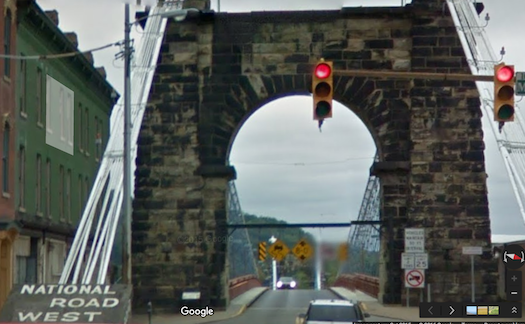
We remained on the Ohio side of the river on Route 7 — part of the Ohio River Scenic Byway — until just outside of Wheeling. We crossed back into West Virginia, choosing to drive over the historic Wheeling Suspension Bridge (map) rather than using the standard Interstate Highway crossing.
It was the largest suspension bridge in the world when constructed in 1849. Obviously the original designers didn’t envision vehicles heavier than horse-drawn wagons when they built it. That meant tight traffic controls in modern times: no trucks, buses or trailers. Cars needed to maintain 50 foot intervals. Traffic lights at either end restricted the number of cars on each pass. We crossed without any trouble in our little sedan.
Independence

The day went so well that we had time stop at West Virginia Independence Hall (map), a place that I discussed previously. This time I could use one of my own photos in the article. Visitors guided themselves through the building although the docent offered a suggestion: start in the basement, take the elevator to the third floor and work back down to the first.
That sounded fine so we started in the basement with an introductory video recounting how West Virginia became a state in 1863. I knew the story already so I spent more time paying attention to the actors than the events portrayed. The video must have been filmed in the late 1970’s because the hairy, bearded men all looked like the Bee Gees circa Saturday Night Fever. The women all sported the poofy manes of that same era. The production values reminded me of a vintage episode of Little House on the Prairie. What was it about again?
The rest of the tour unfolded much more routinely. The third floor recreated the original courtroom where leaders of the day discussed their break from Virginia. The second floor contained an exhibit of various Civil War battle flags, and the first floor held all of the permanent exhibits. The restoration faithfully replicated every detail. Despite its historical significance, the building was allowed to fall into total disrepair in the Twentieth Century. It became a decayed hulk by the 1960’s. The restoration took decades, and finally completed only a few years ago.
Articles in the Counting West Virginia Series:
See Also: The Complete Photo Album on Flickr

Leave a Reply