Look to the far northwestern corner of North Dakota, right up next to Canada and Montana. There sits a county with a curious name, Divide (map). It appeared somewhat rectangular like many other counties on the sparsely-populated Great Plains. Few natural features could take the place of arbitrary straight lines in this emptiness.

I’d encountered Divide County vicariously one time before without even realizing it. That happened as I researched infrequent border crossings between the United States and Canada a couple of years ago. The Noonan border station in Divide County was lonely and isolated. It had only a single pedestrian crossing during 2011 (the most current data available at the time). Of course it also had motor vehicle crossings.
This photo was actually another nearby crossing in Divide County because I couldn’t fine one of Noonan. However, notice the obelisk marker placed by the International Boundary Commission. I don’t know where I’m going with this, I simply liked the image. So, it probably looked a lot like the one at Noonan. Use your imagination.
The Contest
The international border probably wasn’t the divide that inspired a county’s name. Other theories existed like the one described by Dakota Datebook in 2007. [The link to prairiepublic.org no longer works]:
“This time a name for the new county would be determined through a contest. The winning entry came from George Gilmore, a Williston attorney. Gilmore proposed the name Divide County. The Northern Continental Divide runs through the region. The county divides the United States from Canada. It divides North Dakota from Montana. And most importantly, the new county was a product of its division.”

The part about the contest was true enough. Both Divide County and the Town of Crosby (the seat of county government) confirmed the story. It happened in 1910.
Homesteaders were just then migrating into the area. There were just enough people to warrant a new county, thus dividing Divide from larger Williams County. The contest commenced, Gilmore won $5 for his efforts, and the name stuck. The preponderance of sources I consulted mentioned two divisions as the basis for the name. They referenced the divide from Williams County and the continental divide. The notion of state and international borders inspiring a name were apparently modern contrivances.
Northern Continental Divide

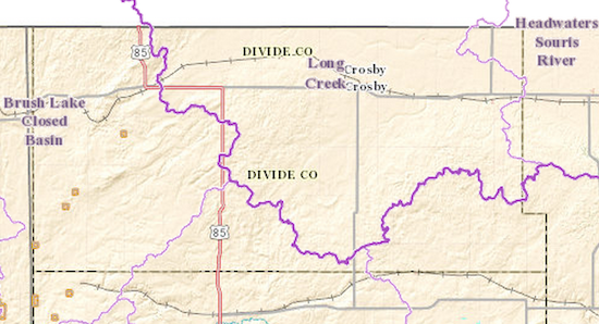
The continental divide fascinated me more in this instance. So I went into the National Map Viewer and selected the watershed layer. Notice the dark purple line that marked the continental divide. Many people see “continental divide” and think reflexively of the Great Divide. That one separated west from east, the Pacific drainage area from the Gulf of Mexico. However, this wasn’t that divide. Rather this was the Laurentian Divide or the Northern Divide. This one separated water bound for Hudson Bay from that heading down towards the Gulf of Mexico.
Divide County’s northeastern quadrant and its county seat at Crosby fell within the Souris River watershed, which flowed into the Assiniboine River River then to the Red River of the North into Lake Winnipeg, then to the Nelson River and finally into Hudson Bay. Divide’s southeastern quadrant flowed a long distance too albeit with a more familiar set of names, from local tributaries to the Missouri River to the Mississippi River, and then to the Gulf of Mexico.
Plus An Endorheic Basin
What about that curious notation on the map? The Brush Lake Closed Basin? Indeed, the western part of Divide County flowed just a few miles farther west. It barely even crossed the border into Montana. Then it stopped at Brush Lake where it remained. A good 20% of Divide wasn’t part of either side of the continental divide. It fell within an endorheic basin created at the tail-end of the last Ice Age as glaciers gouged the plains.
“The buried outwash gravels and the deeper river terrace gravels are very porous and support a controlled groundwater irrigation area, as well as supplying Brush Lake with a continuous flow of water through large springs in the lake. Being in a closed basin, summer evaporation serves as a pump to keep groundwater flowing into the lake. And since evaporation only takes pure water out, the minerals leached from the glacial gravels remain dissolved in the lake and accumulate, giving the lake its distinct color.”
Maybe we should track down Gilmore’s heirs and ask for the $5 back?

Leave a Reply