The Howder Clan found itself in northern Delaware this weekend. Indeed we traveled within the actual Twelve Mile Circle itself which inspired the name of this site. Of course I carved out some time for a few geo-oddities in this very rich concentration of such spots. Some of them I’ve discussed before and others I’ll probably cover on my permanent site. So let’s consider this entry a trip summary without the usual level of detail.
I sneaked out just as the first fingers of light crept over the horizon. Then I hoped to return before the family woke up and started the day. They don’t much understand or appreciate this little hobby of mine although they’ve learned to tolerate it over time. Still, nobody in our family wants to turn our trips into geography lessons so I’m mostly on my own.
(1) Delaware Highpoint – Ebright Azimuth

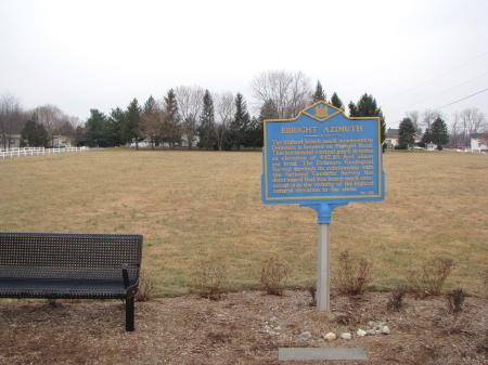
There is absolutely nothing remarkable about the Delaware highpoint (map). Nothing distinguishes it from the surrounding terrain; no hilltop, no view, no discerning features. Hundreds of cars pass here daily and barely a handful would ever notice the roadside marker. Pennsylvania sits a few hundred feet further north and even that nearby horizon looked like it might be slightly higher. Geographers couldn’t even call this place a hill much less a mountain. So they had to go with azimuth, a reference point for measurement.
On the other hand there can’t possibly be an easier state highpoint to visit. Just drive up and park along the nearby residential street perpendicular to the site. Officials recently moved the sign to the “correct” side of Ebright Road. That must have been fairly recent as Google Street View still places it on the other side. Also the state built a nice traffic nub immediately in front of the sign. That slows down approaching vehicles and gives viewers a safe photo platform.
There’s also a bench. One can rest after contemplating the arduous climb up to the summit of this supreme geographic achievement. With all the hoopla and fanfare one might think the little park marks the true state highpoint. It does not. For that, walk another 50 feet or so towards the radio tower. Then look for the chink in the sidewalk marked with white paint. The actual survey marker sits there in bare dirt. I can’t figure out why they couldn’t simply place the sign next to the marker. Aesthetics perhaps.
Also, there’s a little controversy with this highpoint because it’s so darn flat. Some people say the actual spot might sit nearby in the trailer park memorialized by so many state highpointers in their summit accounts. Others contend that the trailer park doesn’t count because the mound it rests upon is artificial. Your call. It’s easy enough to touch all of those bases if that’s a concern. Naturally it concerned me so I touched them all.
(2) The Wedge

However, the family did have to suffer through the Delaware Wedge. My wife and I know a couple from our school days who settled in Newark, Delaware. It would have been a shame to miss them since we were up in northern Delaware anyway. So we made plans to visit with them for the afternoon. Newark is a stone’s throw from the Wedge, and only slightly out of the way. You can guess where this is heading.
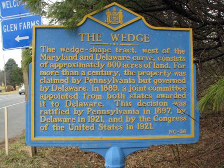
The Wedge resulted from a compounding of surveying errors. I’ll keep this brief for today. Essentially surveyors ran into a bunch of problems trying to connect the Mason-Dixon line with the Twelve Mile Circle. The result fell about 3/4 of a mile off. This left an 800 acre wedge, a no-man’s land or an every-man’s land depending on your point of view, that provided shelter for all kinds of lawless acts. Nefarious activities existed even into the Twentieth Century. For instance, bootleggers used the proximity of multiple state borders to stay one step ahead of the law during prohibition.
Coincidentally, an article on the Wedge appeared in Wilmington’s newspaper, the News Journal, just four days before my visit (“Delaware’s Triangular Oddity“). I wish I could provide a link but I couldn’t find it on-line. That’s a shame because they did a great job on it, in full color and with insightful graphics. Given that, I wondered why we were the only visitors at the Wedge marker on such a lovely Saturday afternoon. The family responded with their typical eye-roll. They wouldn’t even get out of the car. Then they forced me to trudge over to the marker and record this momentous achievement all on my own (map).
From there it’s possible to continue on New London Road (Route 896) for another half-mile or so. This will clip the corner of Maryland and hit Pennsylvania about thirty seconds later. At least my older son thought that was pretty cool. However, thirty seconds was the extent of his attention span. That equaled the same amount of time he could pull himself away from Lego Star Wars on his Nintendo DS. Nonetheless he thought it was amusing so perhaps there’s hope for him.
(3) Twelve Mile Circle Stones

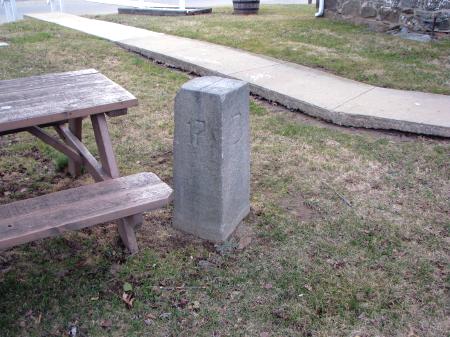
Delaware Twelve Mile Circle stone #17 sits a few hundred yards away from Ebright Azimuth. So I collected that sighting while I was on my adventure earlier in the morning. This stone dates to the 1892 United States Coast & Geodetic Survey effort to set the arc boundary definitively with newer techniques. Stone 17 is supposedly one of the best preserved and most easily accessible of the 46 stones placed during this survey. I’ll vouch that it was both legible and easy to find (map).
I drove down a private road through the trailer park just over the Pennsylvania border. Then I parked in the small lot next to the stone. No, it’s not a parking lot just for the stone. Only a few oddballs such as myself care about such things. The lot’s actually for the trailer park office which is housed in the old, historic Ebright home. But the marker was right there no more than a few feet away next to a picnic table.
Of course nobody was stirring at that time of the morning because that would be silly. As a result, that let me take lots of photos devoid of humans in the background. The best fun fact here is that the Delaware/Pennsylvania border seems to split right through the Ebright home. I’d love to live in a house like that. Eat dinner in Pennsylvania, sleep in Delaware, and that kind of thing.
Interestingly there was also a geological survey control marker maybe another twenty feet away. Some of the waypoints I’ve seen marked on various Internet sites confuse this with the Delaware highpoint. Nonetheless it’s clearly across the border in Pennsylvania if only by a few paces.
Bonus! – Arc Meets Wedge

I was quite pleased with my efforts but it turned out I wasn’t quite done. We arrived at our friends’ house and I relayed our adventures. That’s when I received a copy of the newspaper article freshly pulled from the recycling bin for my benefit.
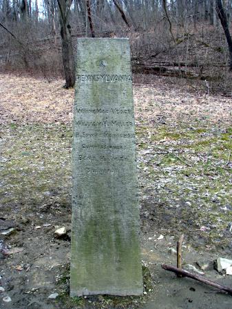
The husband also said he’d been mountain biking along the trails in Walter Carpenter State Park (within the Wedge). There he noticed a marker maybe five feet tall and wanted to know if I’d like to see it. It was only five minutes away as is everything in the constricted northern reaches of Delaware, so it would be an easy trip. Well, duh, of course I wanted to see it! Soon we were on the way back to the wedge, leaving the rest of my family behind with his wife. Frankly, they were all quite grateful to avoid this opportunity.
So we cut down a narrow, winding asphalt track called Hopkins Bridge Road. Then we kept our eyes open for a stone shaft set in a clearing in the woods. We worried we might get hit from behind if we pulled over. This might need to be a quick dash-and-shoot.
However, when we arrived we noticed a small pullout on the other side of the road just large enough for a single car. I’m sure this was provided purposely. Thanks should go to the State of Pennsylvania for this convenience since we’d just crossed their border. From there it was a simple walk a few yards into the woods (map).
Three remarkable geographic oddities plus a bonus with minimal effort. My Delaware visit went much better than I’d ever imagined.

Leave a Reply