Fanciful States

I often see queries on the site along the lines of “Map of counties in State X that border on State Y.” I’m not entirely sure why this is a topic of such interest but apparently there are people who care about such things. There aren’t a lot of resources on this monumental topic so they all seem to land on my page.

I never wondered about it before but it crossed my mind while I was tinkering with some simple maps, and next thing I knew I’d produced a number of them. Usually it creates a rather boring ribbon, either north-south or east-west, or sometimes diagonally.

That’s not always the case. Sometimes the collected border counties produce beautiful, fanciful shapes. I selected a few of my favorites and now present them purely for amusement. There’s no larger significance and there’s nothing much to learn. Just enjoy them.

If you want to make a game out of it, that’s fine too. In that instance, see how many of these new “states” you can identify. I’ll provide each answer directly after the image so I won’t give away the solution inadvertently should you wish to take the challenge. Scroll down carefully and you’ll be fine.


Ready? I’ll start with an easier one.
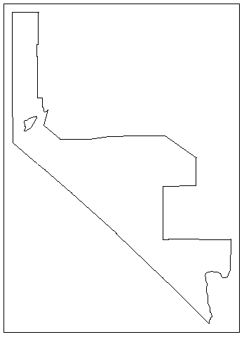
Nevada Counties Bordering California. Image by howderfamily.com; (CC BY-NC-SA 2.0)

The giveaway is the long diagonal line. Indeed, this is an outline map of Nevada counties that border California. I think this one may actually be my favorite because it includes an enclave. That’s Storey County. It does not border California in the slightest but it is completely surrounded by counties that do, plus the independent city of Carson City which also borders California.


Another One on the Easier Side
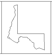
West Virginia Counties Bordering Pennsylvania. Image by howderfamily.com; (CC BY-NC-SA 2.0)

This one should be fairly recognizable too. I think one clue is the horizontal and vertical line that forms a corner. Maybe the northern protrusion has a familiar look. Indeed, that’s the unmistakable shape of West Virginia’s northern panhandle so these are the counties adjacent to Pennsylvania.


Gigantic Counties!
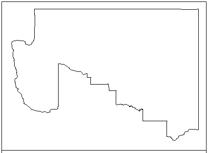
Arizona Counties Bordering Utah, Image by howderfamily.com; (CC BY-NC-SA 2.0)

Did I say that border counties often form a thin ribbon? Not here. In this case the counties take up about a third of the state! These counties are massive, and when combined cover more acreage than some of the eastern states. The upper-right quadrant contributes to the famous Four Corners. These are the counties of Arizona that border Utah.


The Big “U”
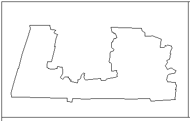
Massachusetts Counties Bordering Connecticut. Image by howderfamily.com; (CC BY-NC-SA 2.0)

I love this U-shaped creation. Would it help if I told you that the bump along the bottom is known as the Southwick Jog? My blogger friend Steve at CTMQ would say, “take back the notch!” We’re talking about the Massachusetts counties that border Connecticut including that sneaky little appendage.


Nixon’s Face?
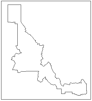
Idaho Counties Bordering Montana. Image by howderfamily.com; (CC BY-NC-SA 2.0)

This is a really attractive shape, isn’t it? I’ve enjoyed the twists and turns as I continue to contemplate it. A really odd Facebook page [link no longer works] equates one side of it to Richard Nixon’s face. The Bitterroot Range is a better explanation. These are the Idaho counties that border Montana.

There are many more instances which I’ve left for you to discover. I might produce more maps if anyone is interested or if I get bored. I might also produce a slightly different set of maps that include the border counties of both states combined. Some of those are even more bizarre.


Posted

in

,

by

Comments

7 responses to “Fanciful States”

  1. Peter Avatar

    So I see this link on Facebook earlier today to a site called “Flagging Headquarters.” I look at the site, and there are articles about whether Britain counts as one country or four, whether Taiwan is a country, and similar things. That’s interesting, I think to myself, this must be a site about geographical curiosities like Twelve Mile Circle or Strange Maps.

    I check the site a bit more, and it finally dawns on me that the “flagging” in question is something, ahem, of highly specialized meaning. It is defined in the Urban Dictionary, specifically the fourth definition. I still can’t believe it took me at least 20 minutes on the site before I finally realized what was up ๐Ÿ™‚

    1. Twelve Mile Circle Avatar

      Oh my! Well that would bring an entirely new definition to County Counting too (and good luck to anyone attempting all 3,143)

      1. Peter Avatar

        Loving County, Texas would be the toughest catch of all given its tiny population … but the name would be quite appropriate ๐Ÿ™‚

        1. Twelve Mile Circle Avatar

          Without a doubt. Its 67 residents would be very, very busy if this ever caught-on.

    2. Steve Avatar

      While no one here wants to delve into the topic, I feel compelled to tell the TMC world that once, in a rathskellar club/bar in Chicago, Il (ca. 1999), I danced in a very lascivious manner with a rather attractive young woman from Mongolia, who barely spoke a lick of English.

      The further details of our daliance remain hazy (though certainly no flags were earned, but for some inexplicable reason, I remain proud of this episode from my single days.

      My wife? Not so much.

  2. James D Avatar
    James D

    I’d like to see a map of Delaware counties that border Maryland. ๐Ÿ˜‰

  3. Mr Burns Avatar
    Mr Burns

    When I first read this, I laughed to myself about how boring your map would be if it were, say, “Kansas counties that border on Oklahoma” or the same thing with bordering on Colorado. Honestly, I expected it to be an almost perfect rectangle. A quick look at the map shows that the interior boundaries zig and zag all over. Not terribly interesting, but not really rectangular, either. So I decided to look for the most “boring” shape. I suspect it will be in the flat part of the country, where borders are set with township/range surveying rather than mountains or rivers. So far, the nearest I’ve come to a rectangle is “Minnesota counties that border on Iowa”. There’s a little jog around Olmsted county, and of course the river at the eastern end, but it’s close.

Leave a Reply

Your email address will not be published. Required fields are marked *

Latest Comments

  1. Hi Mr. Howder — Just going from memory, I recall that your “rule” for counting a nation/state/county is “if I’m…

  2. Does anyone have actual music to the song – Tanaha ,Timpson. Bobo and Blair ?? It was recorded by Tex…