Longtime reader “jlumsden” knows that I love to hear about the geo-adventures of my Twelve Mile Circle audience. Thankfully he’s kind enough to share some of his experiences with us.
I haven’t encountered a lot of the world personally. That being the case, at least I can travel there vicariously through the adventures of others.
Last time in June 2009, he arrived at South America’s Triple Frontier. Here, Argentina, Brazil and Paraguay join at a single point. Now he returned to Brazil for an entire month. On the latest excursion he’s gone to a number of spots including Belo Horizonte, Mariana, Ouro Preto, Recife, Rio de Janeiro, Salvador de Bahia, and Sao Paulo.
I’ve enjoyed following him on Google Analytics as he hits my website at each new town and puts another dot on my visitor map. Yes, I can track his progress in almost real-time. Also, I certainly wished I could be there in person during a chilly North American winter. Rio, where he visited today, hit 32°c. (89°f.).
That’s not what he wanted to share although it’s still quite interesting. He knows I enjoy islands — the more obscure the better — and he made it all the way out to the archipelago of Fernando de Noronha during this sojourn. I find it comforting in a sense when the audience begins to understand my quirks. And yes, for the record, I do maintain an unnatural fascination with islands.
Middle of Nowhere
Fernando de Noronha certainly fits the definition of obscure. The archipelago of 21 islands rests some 350 km. (220 mi.) off the Brazilian mainland. Only a few airline flights arrive here each day. Everything must be imported so it costs a lot of money. Only a couple of thousand people live there permanently. Thus, visitors don’t stumble upon this place randomly.
Historically, nobody really seemed to know what to do with Fernando de Noronha. Sure, various European powers occupied it over the years. They built fortifications and considered it vaguely important. Nonetheless, it ping-ponged between Portugal, England, France, and the Netherlands, before landing in Brazil upon its independence. In later years the archipelago became a remote prison site, a node for transatlantic telegraph cables, and an airline way station for passengers and freight. Today the economy depends on tourism, primarily eco-tourism as a UNESCO World Heritage Site.
You can read Wikipedia as easily as I can if you want to know more. Let’s get on to some observations from jlumsden and a few photographs taken by one of his fellow travelers, used here with permission.
Location

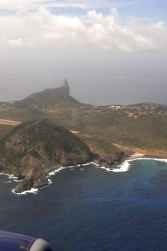
The airplane prepared to land on the primary island in this image. It comprises about 90% of the archipelago’s landmass. Also, you can see a big chunk of it in just this one photograph. Fernando de Noronha doesn’t cover much territory way out here in the ocean.
Jlumsden notes that it’s the closest Brazilian territory to Africa. In fact it comes closer to Senegal than to many areas of western Brazil. I prepared a map for an article a few months ago that shows a similar relationship using a different Brazilian location. Indeed, this qualifies as one of those fascinating but little-known facts about Brazil.
He also thought I might be amused to learn that Fernando de Noronha falls within the Brazilian state of Pernambuco even though the archipelago sits considerably closer to other Brazilian states including Paraíba and Rio Grande do Norte. Indeed, that kind of oddity inspires me.
The Beach

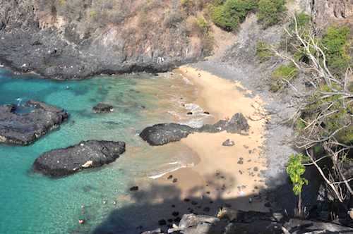
One of the best beaches on Fernando de Noronha resides at Baia dos Porcos. That translates literally to “Bay of Pigs” in English. A natural landmark known as the Two Brothers rocks hems it in. I did some quick web searches along with Portuguese translation options and found that many consider this one of the top beaches in Brazil. That certainly seemed impressive given all the great Brazilian beaches.
Village of Air France

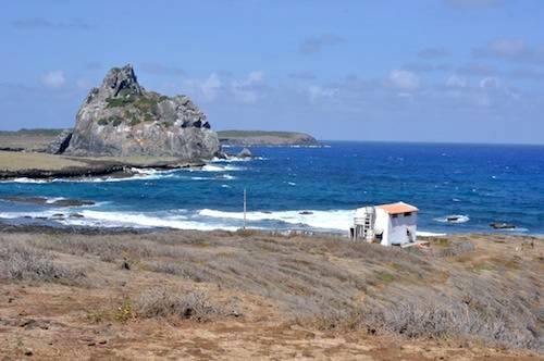
I love this photograph. First, I found it visually stunning. More important, considering my fascination with weird situations, is that this is the final remaining vestige of a town called Air France. Jlumsden explained that Air France staff lived in this paradise back in the days when airplanes refueled and reprovisioned on Fernando de Noronha. Transoceanic flight couldn’t be completed in a single hop in the 1930’s. Does anyone know of another town named for an airline?
Thank you for sharing, jlumsden! Enjoy your final few days and return safely.

Leave a Reply