
The skills of the people who read Twelve Mile Circle continuously impress me. I love their ability to expand upon a theme I’ve presented, and their willingness to share the results of their efforts with other readers. Today it’s wonderful to post a map produced by “Colin”. He uses my Flipping Lat/Long Directions article as its starting point.
Previously I started with selected long/lat coordinate and flipped the signs between positive and negative. Then I determined whether the four possibilities resulted in wet or dry landings. I mentioned that I had a hard time finding a base coordinate that resulted in four dry landings. Unfortunately I found only one:
- 49.348985,69.342041 = Central Kazakhstan
- 49.348985,-69.342041 = Québec, Canada
- -49.348985,69.342041 = Grande Terre, French Southern and Antarctic Lands
- -49.348985,-69.342041 = Southern Argentina
Then Colin expanded on this by at least a couple of orders of magnitude. He produced a map where all four possibilities generated a land-based point. With Colin’s permission, here are the results:
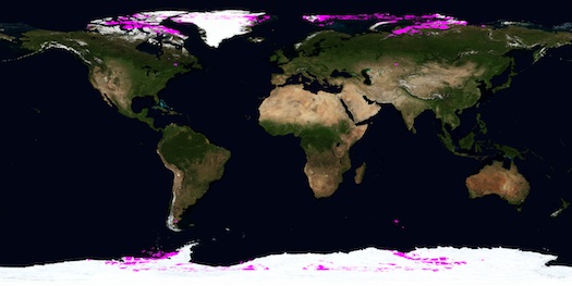
It’s a beautiful map and unfortunately I’ve had to scrunch it down both to fit into the window and to prevent bandwidth drain, which is a shame because I could spend hours gazing at it.
This map also shows clearly how lucky I was to find my example of a quadruple landfall. It’s practically the only instance that isn’t near the poles.
Thanks again, Colin!
Leave a Reply