I’m planning for three, maybe four road trips of significant length coming up over the next several months. All of them will involve significant County Counting components. While I’ve put a big dent into my quest to visit every county in the United States, the total still represents considerably less than half of those available. I’ve been pondering several strategies as I’ve examined places that will require significant effort. That led me to stare at a lot of county maps lately, examining them from a variety of perspectives. I don’t think I found anything earth shattering although I tucked a few observations away for future reference.
Square Miles (land area only)

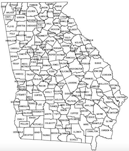
Georgia continues to confound me. How will I ever finish a state with so many tiny counties crammed within its borders? For sure, I will see every corner and crevice of Georgia by the time I finish. I examined a bunch of other states with tiny counties and I began to wonder which one had the smallest average county size. Being the precise person that I am, of course I created a spreadsheet to calculate and rank them. The smallest average county size belonged to… Rhode Island averaging 207 square miles per county (feel free to convert to square kilometres if you prefer). That hardly seemed a challenge though. Rhode Island only has 5 counties. Plus, I’ve already visited every one of them.
Second place, with an average county size of 297 square miles, went to Virginia. I’ve already finished that one too. That was a difficult feat — and I live there! However Virginia came up near the top only because it had those 38 insanely small Independent Cities. Take away those and Virginia would fall to #8 on the list. Next came Kentucky and New Jersey, and only then Georgia, followed by Tennessee.
Every state in that grouping featured an average county square mileage somewhere in the 300’s. All of them will be difficult to finish except for New Jersey which has only 21 counties. Georgia has 159! Texas fell way down on the list with an average county size of 1,028 square miles. Even so it will be frustratingly difficult because of its immense size combined with a jaw-dropping 254 counties.
I figured larger western states with fewer counties would be an easier accomplishment. That might be true in general. However, Alaska might be the exception. If one considered its boroughs and each of the individual Census Areas of the Unorganized Borough (all considered “county equivalents” for these purposes) they would hit an average size of 19,677 square miles. Yet it would be difficult, time-consuming and expensive to visit them all. It would probably involve chartering private airplanes.
Population (2016 estimates)

I didn’t stop there however, maybe because I was on a roll, although my next tangent had nothing to do with County Counting. The spreadsheet was already set up so it was pretty easy to add another column and replicate the study with populations. Just because. Why not?
South Dakota featured the fewest people per county on average, with only 13,113 residents each. North Dakota and Montana followed next in line, each with an average of fewer than 20,000 people per county.
Alaska served as an interesting anomaly once again. I figured it would be lower on the list than #6. However it had a fairly sizable population even though nearly everyone lived in only two boroughs; Anchorage and adjoining Matanuska-Susitna. That skewed things. Rankings probably would have changed if I’d bothered to examine median rather than average. That would have entailed effort and I’m lazy so we’ll never know.
California fell at the complete opposite end of the spectrum. There, the average county population hit an astounding 676,724 residents. The average California county had a larger population than the entire states of Wyoming or Vermont! Crazy.
I found another oddity. Two very different states had nearly the same number of counties and total population: Arizona and Massachusetts. That happened despite Arizona being nearly 15 times larger than Massachusetts. It served as a wonderful demonstration of larger western states with larger county sizes in contrast to smaller eastern states with smaller counties.
The Complete Oddball

What if the District of Columbia ever became a state? DC would be composed of a single county of 61 square miles, and a population of 681,170 residents. That would make DC the state with the smallest average county size, by far. It would also be the state with the largest average county population. County counting would be really, really easy there too.
I travel into the District of Columbia nearly every day so I think I have that one covered.

Leave a Reply