While researching family history recently I came across several distantly related individuals who were born and married in the town of Audubon, Iowa, a place that is also the seat of government for a county of the same name. I wondered, as I combed through archival records, whether they commemorated famed 19th Century naturalist, ornithologist, artist John James Audubon. History knows him best for his landmark publication, The Birds of America.
Naming a County and a Town
Sure enough, the county and town both got their name from the predictable Audubon and not from some unknown random Audubon if one existed. Certainly he wandered widely across the frontier while recording and collecting bird specimens. Nonetheless he didn’t have a strong association with this exact parcel. The Audubon County Historical Society explained that it had more to do with coincidental timing.
Iowa grew rapidly during the middle 19th Century. The state organized forty nine new counties in 1851 alone, all of which needed names. John James Audubon, already famous during his lifetime, passed away that same year and became a logic choice. Audubon County debuted soon thereafter.

Audubon, the county and the town, embraced its namesake with various artworks and commemorations. Those included a large stained glass window with clock (above), a statue of Audubon and his dog Zephyr in the downtown plaza, various tile mosaics replicating artwork from The Birds of America, and several murals in public buildings scattered throughout town. Google Street View provided poor coverage of Audubon and I found few decent Creative Commons licensed images elsewhere. Fortunately the county’s tourism and attractions page offered several photos and a nice overview if you want to see examples.
Other oddities interested me more, anyway.
Weird Size

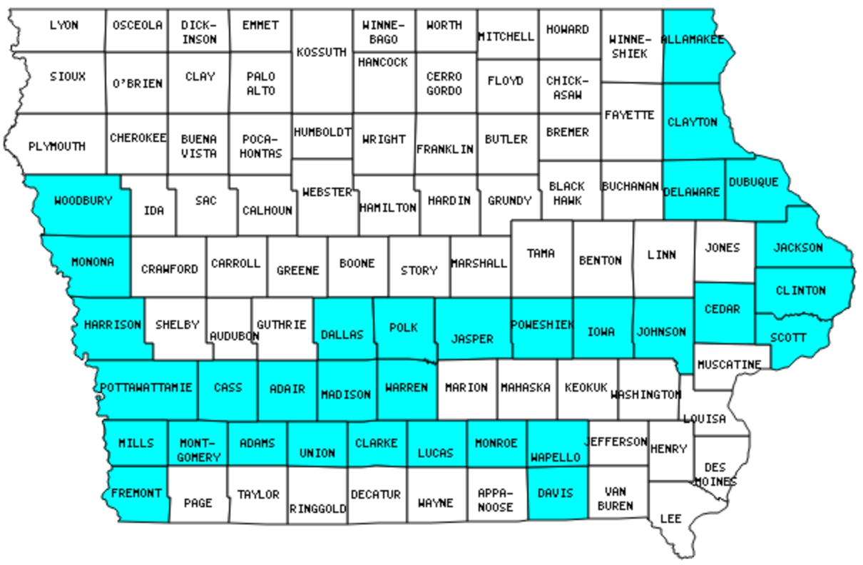
I began by locating Audubon County within Iowa. On the map, count up four rows from the bottom and three counties from the left. There. See it? I used an Iowa map from my county counting page and I have to apologize for being too lazy to create a completely new map marking Audubon specifically. This should still get the point across.
I’ve finished only about 30% of Iowa. Thus, I’m nowhere near a Full Grassley. That’s a story for another day. Ignore that.
Rather, focus on Audubon in relation to its neighbors. Specifically notice that it’s considerably skinnier than any other county on the same horizontal row. An old publication, The History of Audubon County, Iowa (1915), offered an explanation for this geo-oddity.
“This boundary was changed… [and] the cause of this change was remote. To adjust the boundaries of Polk county in such manner as to make Des Moines nearer the center of the county a tier of townships was severed from the east of Polk and attached to Jasper county. To compensate for the change a tier of townships was taken from the east of Dallas and attached to Polk county. Then a tier of townships was taken from the east of Guthrie and attached to Dallas county and a tier of townships was taken from the east of Audubon and attached to Guthrie county.”
The publication then explained that nobody of consequence lived in Audubon at the time to defend its interests so the horizontal dominoes stopped falling right there. The county lost land to the east and gained nothing to the west. Audubon got squeezed. I had a more colorful term for that predicament although I couldn’t use it on a family-friendly website.
Oversized Animals
I returned to the tourism and attractions page and convinced myself that I needed to travel to Audubon County someday. Audubon, you are now officially on The List. I’m a sucker for oversized roadside animals like Audubon’s “Albert the Bull.”

Roadside America liked Albert too. It said,
“Albert, the World’s Largest Bull, has been guarding the peaceful streets of Audubon since 1964. He is 30 feet tall and 33 feet long, and has a 15-foot span between horns. He also has baby blue eyes and giant concrete gonads.”
Tree In The Middle of the Road
Audubon was also justifiably proud of its aptly-named “Tree In The Middle of the Road” near Brayton. Once again, Street View failed to capture this remarkable landmark although Satellite View displayed the large tree directly within a crossroads. Various copyright protected photos (for example) exist on the Intertubes for those who need to appreciate the oddity from ground level.
It got better. This also marked a border between Audubon and Cass Counties so the county line went directly through the tree! The tourism and travel page described the situation,
“A surveyor was marking the line between Audubon and Cass counties and used a slender cottonwood branch as he walked. When the line was established, he pushed it in the soft earth at the exact point where the lines crossed and where the present crossroad was to be in later years. The switch took root and it has grown into today’s tall and widespread 100 foot tree.”
I thought the story sounded bogus. But let them have their tall tale if they like. It didn’t matter. A giant tree as rural roundabout generated abundant weirdness all by itself. I’d go maybe several miles out of my way to see this, for sure.

Leave a Reply