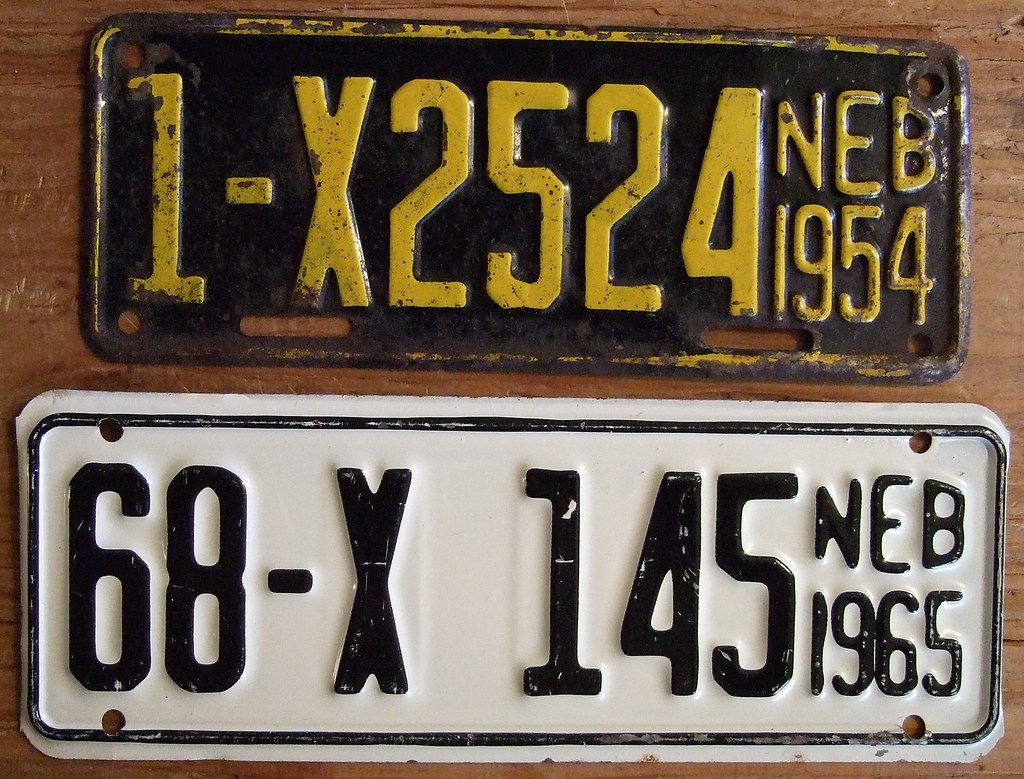
Recently I spotted an automobile with a Nebraska license plate, or more properly a “vehicle registration plate” I suppose. That wasn’t an everyday occurrence here in the Mid-Atlantic more than 1,100 miles (1,770 kilometres) from that Midwestern state. Often I’ve wondered what would bring a driver such a long distance from his home after I’ve spotted such an unusual plate.
In the Washington, DC area it was generally someone serving in the military at one of the many local bases, although now I’ve started going down a tangent. Back to the point, it reminded me of one particularly fascinating feature of Nebraska’s plates, that they traditionally contained not-so-secret geographic codes within the identification scheme. That beautiful pattern began to break down in recent years and I’ll get to that in a moment.
About Nebraska

One could, and to a degree can determine the county where the driver lived when the vehicle was first registered. The state began issuing county-coded plates in 1922 and fixed its pattern on the current population. All plates issued within the most populous county began with with the number 1 and so on down to the 93rd county. The enumeration at that time began with the 1920 Census so Douglas County grabbed number 1 with with 204,524 residents. That made sense. The city of Omaha fell within Douglas County and it had a lot of people.

Number 2 went to Lancaster County with 85,902 residents. Again, that made sense. Lancaster contained Lincoln, the capital of Nebraska, and naturally it had a lot of people too. The pattern continued all the way down to remote Hooker County with a mere 1,378 residents in 1920, designated thereafter with the number 93. Interestingly, Hooker County never had a larger population. Only 736 people lived there in 2010.
Examine the Nebraska license plates, above. The first one designated a vehicle registration in Douglas County (1). The second one referenced Keith County (68) towards the western side of the state.
An Elegant System Couldn’t Last Forever
I’ve never lived in Nebraska although I spent significant time there for maybe a five year period ending about a dozen years ago. I got pretty good at memorizing the license plate codes for counties surrounding Omaha because I’d see them fairly regularly. That’s why I was sad to hear about changes to the system as I researched this article. The system started breaking down because of specialty plates. The state announced a plate to recognize its sesquicentennial just a few days ago.
However I’d stumbled upon a more direct assault, Nebraska Revised Statute 60-370.
I guess one could blame Nebraska’s growing popularity, particularly along the expanding edges of Omaha and Lincoln. Reserving the first digit for a 1 or a 2 would limited the number of unique combinations available on the rest of the plate.
Plus there was Sarpy County to further complicate the situation. Back in the 1920’s its diminutive population earned Sarpy a lowly 59 on the list. However, it became a booming Omaha suburb in recent decades, growing at a 20% pace. Nearly a hundred and sixty thousand residents lived there by 2010. Sarpy more than anything else blew the entire basis of the old code to pieces. The third most populated county in the state still had code 59.
Revision
Nebraska revised the statue to read:
“… registration of motor vehicles or trailers in counties having a population of one hundred thousand inhabitants or more according to the most recent federal decennial census shall be by an alphanumeric system rather than by the county number system.”
Certainly, the vast preponderance of Nebraska counties by number retained their geographic codes. However the set of counties with the biggest chunks of people switched to boring three-letter / three-number combinations found just about everywhere else.
I took a quick look at Nebraska counties with “a population of one hundred thousand inhabitants or more” (i.e., Douglas, Lancaster and Sarpy) and compared them against the state as a whole. Those three counties alone accounted for an astounding 54% of Nebraska residents. The remaining 46% were spread amongst the other 90 counties!
Other States
I also learned that several other states had license plate coding schemes that identified counties to one degree or another. Wikipedia had the details although not included within a single list. I’ve done the hard work so readers won’t have to hunt for the information themselves.
- Alabama – by population.
- Idaho – a weird alphabetical system
- Montana – by population
- South Dakota – by population
- Wyoming – by population
- Oklahoma – used to be by population; sadly no more
Geographic codes may be more common outside of the United States. I know that one could tell the home registration of vehicles in Ireland by an alphabetic code. I noticed that when I was over there last summer. For example, one could easily identify most of the tourists in Killarney because their automobiles had a “D” in the middle position of the plate. That designated a vehicle from Dublin. Likely, a tourist picked it up as a rental car after landing at Dublin Airport. It also increased the odds of an American driver not used to driving on the left side of the road. Proceed with caution!

Leave a Reply