Fortuna was the Roman goddess of prosperity and luck. That would be an excellent name for any location hoping for some of that mojo rub off. I was aware of a Fortuna in California (map), probably the largest Fortuna in the United States. People there lived in the heart of redwood country.

I’m sure it’s very nice and I’d love to go there someday and experience the Avenue of the Giants. However this Twelve Mile Circle wasn’t about that particular Fortuna. Maybe I’ll circle back to that one eventually. Not today.
Another Fortuna
Rather, I became fixated on the Fortuna I’d uncovered as I investigated the intricacies of what divided Divide County in North Dakota. There sat tiny Fortuna, population 22, all alone on the Great Plains (map). Let’s ride along on a little driving tour given by some random guy on YouTube, shall we?
Hmmm… there wasn’t much there, was there? A church, a gun club, a curling club, a few houses and a senior center.
Don’t let the starkness deceive you. Look below the surface and every place is a geo-oddity. I myself live in the smallest self-governing county in the United States. I’m sure your little corner of the world has its own unusual geographic distinction too. Fortuna (pronounced For-Toona) was fortunate enough to have two unusual features, one created by nature and one caused by the arbitrary placements of lines by man.
Endorheic Basin
We already discussed the first condition in County Divided: the Brush Lake Closed Basin. Fortuna fell barely within the eastern edge of this endorheic basin. Sandwiched between Arctic and Atlantic watersheds, water falling in Fortuna wouldn’t flow to either ocean. Instead it drained to nearby Brush Lake just over the border in Montana where its overland journey ended, trapped in a gouge carved by ancient glaciers during the last Ice Age.
The Latest Sunset

However, the second feature was somewhat more esoteric. According to North Dakota State University, Fortuna had the latest sunset on the summer solstice for any town in the Lower 48 United States, at 10:03 p.m.
That occurred because of a confluence of a couple of different situations. Fortuna happened to be located at the far western edge of the Central Time Zone. The zone had a nub in northwestern North Dakota that made Fortuna considerably farther west than almost any other place along the time zone edge.
The exception was a corner of west Texas east of El Paso, say, somewhere like Van Horn (map). It was just a little farther west than Fortuna. However there was a different factor that more than made up the difference: latitude.
I put the points into a great circle mapper and found that Fortuna was about 1,250 miles (2,000 kilometres) farther north than Van Horne. Thus, with that large of a difference I think it would be safe to speculate that sunset happened later on the summer solstice in Fortuna’s corner of North Dakota than anywhere else in the Central Time Zone. I suppose I could also check the other three U.S. time zones in the Lower 48 for their westernmost extremes although I’m simply not that motivated. The Intertubes said it was true and I left it at that.
But Wait, You Also Get This
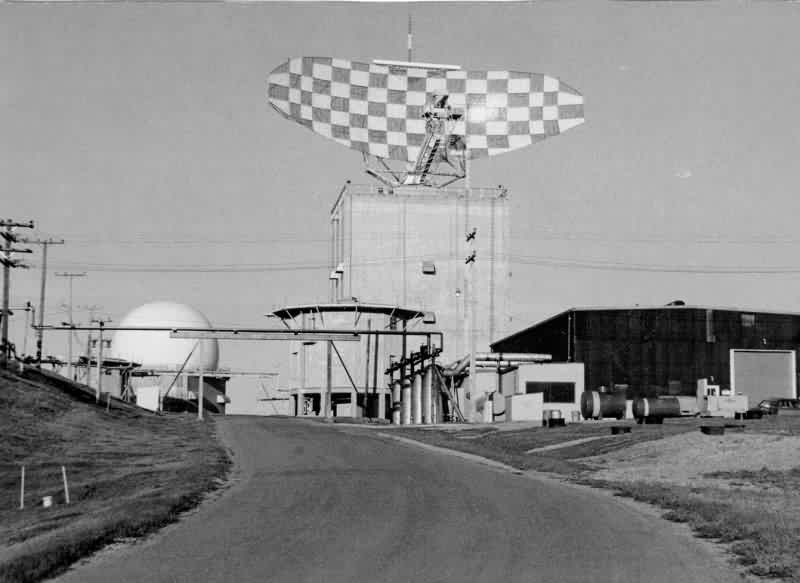
Fortuna had history. I hardly would have expected anything of historical significance in such a remote corner. Yet, ironically its remoteness actually created its importance. These out-of-sight places made ideal locations for a variety of Cold War artifacts.

The U.S. government constructed Fortuna Air Force Station just outside of town, a radar base operating from 1952 to 1984. It was designed to track enemy aircraft and coordinate their interception should Soviets bombers attack the United States. The site was completely abandoned once the Cold War faded and fell away. Ghosts of North Dakota visited the old station recently and noted,
“We got word that this base was to be demolished in 2013, so we set out to photograph it before it was too late… The radar dishes and domes were removed long ago, and the site has since been heavily vandalized and scavenged. The salvage rights were sold some years back and the team that did the salvage knocked holes in the walls of most of the buildings to remove boilers and scrap metal.”
The station may soon become just another patch on the plains before too long. Even so, Veterans of the 780th AC&W Radar Squadron still keep in touch.
What does the future hold for the town of Fortuna? Perhaps something fortunate. This quadrant of North Dakota has boomed in recent years because of oil discoveries in the Bakken formation. The population of Divide County increased by more than 10% between 2010 and 2013 (the latest figures available) after decades of decline.

Leave a Reply