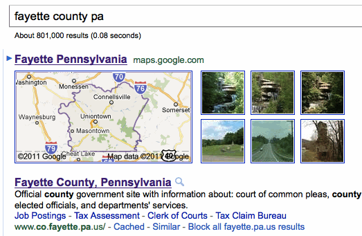
Are county boundaries finally on the way to Google Maps? County Counters including myself have bemoaned the complete lack of county lines in Maps, having to rely on Mapquest and other sources instead. Last night, however, I went to Google and searched on Fayette County, Pennsylvania. The result shocked me.

Check it out! That’s an embedded image of Fayette County within the Google search results, in the familiar Google Maps format. How long has that feature been there? I’m a fairly heavy user and that’s the first time I’ve seen it. I clicked on the image and it carried me to Maps, but once I landed there the county lines disappeared again. That seemed odd.
Someday, maybe someday county lines will appear in the image I imbedded above. That’s not the case as of May 2011 though.
A Closer Look
I went back to the Google search engine results and started plugging-in random county names. It seemed that perhaps 60% of counties displayed with similar maps. The others county names produced no maps at all. It also seemed to produce results for many states but not all, leading me to believe that I may have stumbled across some kind of work in progress. Google probably isn’t ready to roll it out publicly but clearly they’re testing something.
Maybe Google is listening. More than a year ago, all the way back in February 2010, I posted an article called Let’s Get County Lines Drawn on Google Street View. I’d noticed that Google had a page called Suggest a Feature for Maps. People could select several options including one called “Show county boundaries on the map” with a button labeled “Suggest It.” I asked people to click the button and many of you did. The button still works so if you haven’t suggested it previously, please take a moment and give them a little encouragement to continue with their effort. If you tried this last year, well, why don’t you go ahead and try it again? I did. Let’s see if we can push their test into production.
Why Not?
I’ve often wondered why Google hasn’t added those lines yet. No, I don’t lead a very exciting life. I have a couple of theories and maybe you do too. First, we know that state and even national boundaries in Google Maps can be off by anywhere from a few feet to perhaps a hundred. Maybe they’ve had trouble overlaying all of the counties with a decent level of precision? Is that why they will only show them as an embedded image in a search? On the other hand, they’ve long had a county border layer in Google Earth apparently without precision issues so it shouldn’t be too difficult to recycle the same data file.
Second, and I know this will shock the county counting community, but maybe Google doesn’t think their users are all that interested in county lines. Maybe Google doesn’t want to clutter their maps? However, Mapquest also targets the general populace and they don’t seem to have any county line concerns. Also I can’t believe it wouldn’t be more popular than some Google Map options. How many people really use the webcam feature?
I’ve been stumped. Now I’m encouraged. Google started displaying county lines in a limited fashion. Can a county line feature within Google Maps itself be far behind? If it happens… remember you heard it on 12MC, first!

Leave a Reply