People seem more interested in time zone anomalies than many other quirks I discuss. I know this because I get lots of random one-time visitors to the Twelve Mile Circle via search engines. Invariably they are searching these kinds of queries. I like them too, but I try not to overwhelm my regular readership with stories about these artificial creations. Several weeks ago I alluded to a particularly audacious anomaly as a comment to one of my posts. Today I will elaborate.
Baseline
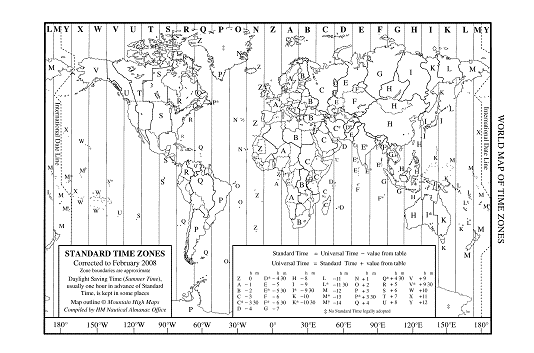
Let’s start with this public domain map I borrowed from the United States Naval Observatory website.

Notice the huge variation in time zones. Small nations tend to select a single time zone. Large nations generally split themselves into multiple time zones according to affiliations that rarely coincide with straight lines of longitude. Now look at China. It stretches 5,026 kilometres east-to-west, and yet it falls within a single time zone in its entirety: Universal Time +8. It’s their country and they make the rules. They can lump everything into a single time zone if they choose, and that’s exactly what they’ve done. Nonetheless it does lead to some interesting situations where China abuts its neighbors.
China Meets Afghanistan
Afghanistan is one of a handful of countries that aligns itself on the half-hour compared to Universal Time, specifically UT+4:30. Afghanistan also shares a brief 76 kilometre border with China at its far eastern tip. Anyone crossing between the two would experience an astounding three and a half hour time change. That’s something one would expect from a multi-hour airline flight, but hardly with a single step forward. That’s exactly what happens here. It forms the greatest time change along a common national border anywhere on Earth.
I thought to myself, well, if the political situation ever improved then this would be a great anomaly to experience in person. However, that’s not going to happen. Apparently only a handful of non-locals have been able to accomplish this feat in the last fifty years. You read that correctly. It almost never happens.
Wakhan Corridor

Maps call this the Wakhan Corridor or Wakhan Salient, a narrow arm of Afghanistan jutting sharply to the east of its larger body (map). At times this extension constricts to as little as fifteen kilometres. Tajikistan borders to the north, Pakistan to the South, and China at its eastern terminus. The corridor itself is an artifact of an earlier time. It separated the Russian and British Empires with a physical land barrier, albeit a very narrow one. Otherwise there is little reason for Afghanistan and China to share a border today. The corridor houses perhaps 10,000 people in widely scattered villages and serves no greater strategic purpose.
The ruggedness of the mountains that would need to be traversed is immense. Afghanistan meets China deep within the Hindu Kush Mountains at 4,923 m (16,150 ft). No road traverses it. A traveler would need to trek it entirely on foot. It’s also impassible entirely at least five months of the year and opened intermittently the remainder of the year due to fierce weather. Also permits would need to be secured in advance. Failure to do so would place a traveler at risk of being arrested or shot on the spot should one stray the wrong way across any of the nearby borders. If all this hasn’t scared you away and If you would like to plan an excursion you can consult the Mock and O’Neil website.
It’s a nice intellectual anomaly. However it’s not one likely to be experienced except by a few local inhabitants and the occasional smuggler.

Leave a Reply