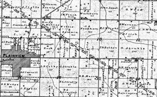
My hobbies sometimes run together. That happened again as I searched an 1896 land ownership map for Wabasha County, Minnesota. There I hoped to find the footprints of a peripheral ancestor. I knew the Nineteenth Century property ownership existed, in fact I’d visited the site in person. However, I’d never seen this particular vintage map before. The print covered a small farming community a few miles west of the Mississippi River, a place called Plainview (map).
An Old Map
I wasn’t expecting anything particularly remarkable. I like old maps and I wanted to gaze upon the family name printed upon it, and I found it quickly. Go ahead and look along the bottom of the image. Then about half-way across for the name E. L. Sylvester on an 80 acre parcel. Edwin L. Sylvester was the eldest son of George W. Sylvester, the original homesteader. Edwin happened to own the property at the time of publication in 1896..

However I noticed something unusual. A diagonal line ran directly through many of the properties in this section of Plainview Township. So I drilled down and read the label. There I found something called the “Sioux Half Breed Treaty Line.” I had absolutely no idea what that was about. I knew from previous research that this branch of my family arrived in Minnesota only a few years after the government had forced Native Americans from their land. But what should I make of this peculiar Half Breed label?
Creation of Half Breed Tracts
I found a surprising amount of information. The U.S. Government and Native Americans of various tribes set aside several of what they called “Half Breed Tracts” in Iowa, Nebraska, Wisconsin and Minnesota. These took place through a series of treaties negotiated circa 1820-1830.
Traders and explorers of European descent had long wandered along the upper Mississippi watershed. They met plenty of Indian women and fathered plenty of children. Alas, neither group completely accepted their blended offspring. Even so, both communities must have felt at least a modicum of responsibility because they set aside specific lands for these people of mixed descent.
The tract in Minnesota, the one I’d spotted on that 1896 map, appeared in Article 9 of the 4th Treaty of Prairie du Chien in 1830.
“The Sioux Bands in Council having earnestly solicited that they might have permission to bestow upon the half breeds of their Nation, the tract of land within the following limits, to wit: Beginning at a place called the barn, below and near the village of the Red Wing Chief, and running back fifteen miles; thence in a parallel line with Lake Pepin and the Mississippi, about thirty-two miles to a point opposite Beef or O-Boeuf River; thence fifteen miles to the Grand Encampment opposite the River aforesaid; The United States agree to suffer said half Breeds to occupy said tract of country; they holding by the same title, and in the same manner that other Indian Titles are held.”
Wikipedia actually has a pretty good overview and provides a map. It is the green block with the number 232 (correction, 292).

A Short-Lived Phenomenon
However, none of these reservations that were set-aside expressly for mutli-ethnic people exist today. They didn’t even exist on the 1896 map I spotted except as an artifact. What happened after their creation is a matter of various views. Some sources claim that the government forced people from these lands on a pretext when it seemed that minerals might be located there. Others claimed more complicated reasons. Essentially, they said, unscrupulous land speculators cheated the treaty beneficiaries from their land. Either way the rightful owners left by the 1850’s due to one dubious scheme or another.
There wasn’t much sympathy for the dispossessed even as late as 1920 when the History of Wabasha County Minnesota wryly noted,
“This ‘Half-Breed Tract,’ the reservation of which was doubtless made through the influence of the Indian traders and those in their employ who had married Indian women, subsequently was the cause of much trouble which delayed the permanent settlement of the lands involved.”
Expansionists viewed occupants and claimants of the so-called Half Breed Tracts as little more than speed bumps blocking “permanent settlement.” That was an unfortunate sign of the times. They removed all evidence of these earlier occupants from the territory with the exception of a series of dotted lines on vintage maps.

Leave a Reply