There are 102 Counties in Illinois – “The Land of Lincoln“
Also be sure to see my United States County Counting Page for the rest of the states.

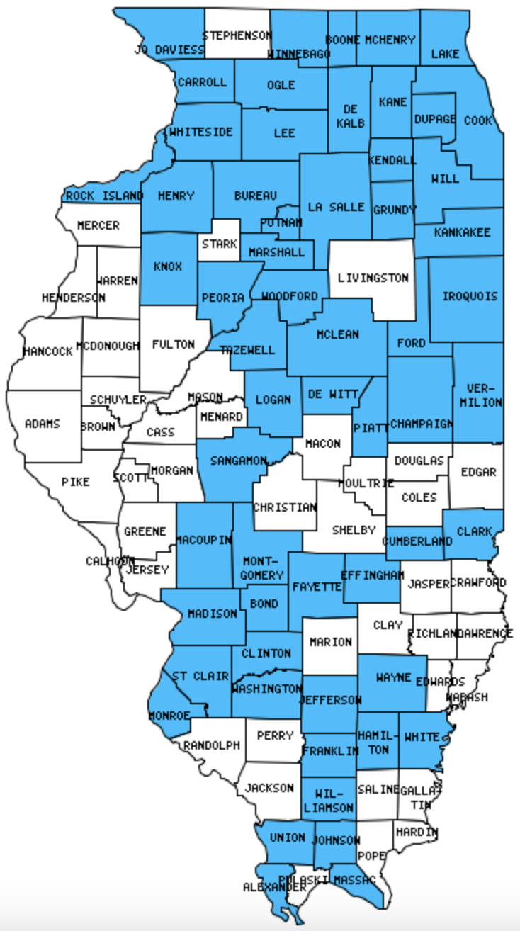
I have visited 58 Counties = 56.9% of Counties in Illinois
Counties visited are colored-in; counties still needing to be visited are blank. Map created using Mob Rule.
Twelve Mile Circle Articles Featuring Places in Illinois
Markers designate the Illinois locations featured in Twelve Mile Circle articles.
Counties in Illinois

Below are the 102 counties in Illinois. Although infrequent, counties sometimes do change so please let me know if any of this information is out of date and I will update it. Those counties that I have visited are highlighted in Red. Readers can also link to any articles manually in this section if the map isn’t working.
- Adams
- Alexander: Future City; Ohio/Mississippi River Confluence
- Bond
- Boone
- Brown
- Bureau: Captain Swift Covered Bridge; Red Covered Bridge
- Calhoun
- Carroll
- Cass
- Champaign
- Christian
- Clark
- Clay
- Clinton
- Coles
- Cook: Largest county population in Illinois (5,376,741 people in 2000 Census); Chicago Fire Academy; Goose Island Beer Company; Millrose Brewing Co.; O’Grady’s Brewery & Pub; Piece Brewery & Pizzeria; Rock Bottom Brewery; They Reversed the Chicago River; Hinsdale Oasis; Old Post Office Building; Rapid Transit in 1844; O’Hare Oasis; Woonerf; Skokie Eruv; Move Along, Nothing to See; Quad County Towns; California Tangential; Broadway & Sheridan; Connecting Through Midway; Midway Plaisance; Orchard Place Elementary; Wacker Drive
- Crawford
- Cumberland
- De Kalb: The Resurrectionists
- De Witt
- Douglas
- Du Page: Founders Hill Brewing Company; Glen Ellyn Brewing Co.; Taylor Brewing Company; 81 on 81; Woonerf; Cut the Corner
- Edgar
- Edwards
- Effingham: Shortline
- Fayette
- Ford
- Franklin
- Fulton: Plank Roads; Beer Cemetery
- Gallatin
- Greene
- Grundy
- Hamilton
- Hancock
- Hardin
- Henderson
- Henry
- Iroquois
- Jackson
- Jasper
- Jefferson: The Other Mount Vernon
- Jersey
- Jo Daviess: The Point of Beginning
- Johnson
- Kane: America’s Brewing Company; The Resurrectionists; Condensed Texas; Quad County Towns
- Kankakee
- Kendall
- Knox
- La Salle: French Canyon
- Lake: Quad County Towns
- Lawrence
- Lee
- Livingston
- Logan
- Macon
- Macoupin
- Madison: I Call Bull Shark
- Marion
- Marshall
- Mason
- Massac: Super City
- McDonough
- McHenry: Quad County Towns
- McLean: Largest county in Illinois (1,184 square miles).
- Menard
- Mercer
- Monroe
- Montgomery
- Morgan
- Moultrie
- Ogle
- Peoria: Grandview Drive; Peoria Zoo
- Perry
- Piatt
- Pike: Adjacent Counties, Same Name, Different States
- Pope: Smallest county population in Illinois (4,413 people in 2000 Census).
- Pulaski
- Putnam: Smallest county in Illinois (160 square miles); Highway to Nowhere
- Randolph: Last Place in the U.S.; The Forgotten River Capital (Kaskaskia)
- Richland
- Rock Island
- Saline
- Sangamon: Sugar Creek Covered Bridge
- Schuyler
- Scott
- Shelby
- St. Clair
- Stark
- Stephenson
- Tazewell: Fondulac Park West
- Union
- Vermilion: Adjacent Counties, Same Name, Different States
- Wabash
- Warren
- Washington
- Wayne
- White
- Whiteside: De Immigrant Windmill; Mississippi Vista
- Will: Plank Roads; Lockport; They Reversed the Chicago River; Revisiting the Chicago River; Gary Coleman on the Grassy Knoll
- Williamson
- Winnebago
- Woodford
Quick Facts About Illinois
- Location: East North Central United States. See map above.
- Size(1): 55,519 square miles. Illinois is the 24th largest state. The next larger state is Iowa and the next smaller state is Wisconsin.
- Population(2): 12,699,000 people. Illinois is the 6th most populous state. The next more populous state is Pennsylvania and the next less populous state is Ohio.
- Population Density: 228.7 people per square mile. Illinois is the 12th most densely populated state. The next more densely populated state is California and the next less densely populated state is Hawaii.
- Bordering States: Illinois shares a border with 5 states: Wisconsin, Iowa, Missouri, Kentucky and Indiana.
- Admission to the Union: December 3, 1818. Illinois was the 21st state admitted to the Union, after Mississippi and before Alabama.
- Capital: Springfield.
- Highest Point: 1,235 feet at Charles Mound. See SummitPost’s Charles Mound page.
- Lowest Point: 279 feet at the Mississippi River in Alexander County.
- Government website: Illinois.gov – The Official Website for the State of Illinois.
- Official Tourism website: Enjoy Illinois.
- Still not enough? See Wikipedia’s Illinois page.
Sources:
(1) Wikipedia: List of U.S. states and territories by area. Land area only.
(2) Wikipedia: List of states and territories of the United States by population. Estimated population on July 1, 2019.

Leave a Reply