I’d had a vague notion of the premise behind the Iron Butt Association, a loose organization of people addicted to extremely long-distance motorcycle rides. But the basic membership, the absolutely easiest level, requires a documented ride of 1,000 miles (1,600 km) within 24 hours. They call it the SaddleSore 1000. Rides quickly increase in difficulty from there. Then they rise to absolutely stratospheric levels. Imagine the 100CC, which involves riding across the entire width of United States and back in 100 hours or less.

Their premier event is the Iron Butt Rally. That’s happening right now if you’re reading this in proximity to when I wrote this (June 2011). They describe it as the “World’s Toughest Motorcycle Rally – 11 Days 11,000 miles”. The rally occurs only once every two years with participants selected by lottery. So that makes it the equivalent of the Olympics for the extreme distance motorcyclist community. Enthusiasts consider simply finishing a prestigious honor.
This fascinates me from a geo-geek perspective because of the map and travel aspects. However, let’s be honest, I don’t ride a motorcycle. I wouldn’t even attempt this feat in an automobile. Nonetheless, I’ve featured extreme geographic coverage before, for example when a group of people attempted to visit every county in New England in 24 hours or less. This time it’s personal because I know someone who is in the rally. [And indeed it is a rally, NOT a race… see comment below].
The Rally Is On

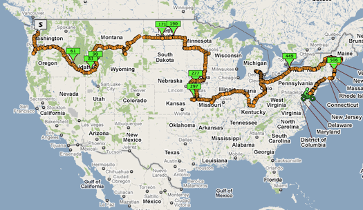
This was a live screen-grab that I captured this morning based on a GPS tracker carried by the rider I know. I’ve been watching the line grow since it started in Seattle nearly a week ago. I’ve intentionally kept this image at a distance to preserve the rider’s anonymity. For example, one can literally see which hotels he stops at each evening in the live zoomable link. So that’s a bit too revealing for purposes of this article. The wide shot hopefully provides an appreciation of the distance covered by this contestant after six days.
There is also an option to view a map of the current position of the the entire field of riders in real time. It doesn’t reveal people by name unless a rider wants to share that information. The geographic spread you see occurs as riders pursue bonus points that I’ll describe below.
Theme
Each Iron Butt Rally has a specific theme. Organizers don’t reveal it ahead of time either. Rather, riders receive it in their rally packet the night before they take to the road. Contestants immediately hit the computers so they can plot their routes and strategies.
Iron Butt selected a fairly simple premise for 2011: “To be classified as a finisher of the 2011 Iron Butt Rally, a rider must visit all 48 contiguous states and reach each checkpoint and the finish before the close of the specified time window.” The organizers estimate the basic route to be 8,325 miles (13,400 km).
However, that is only the minimum criteria to qualify as a finisher. This accomplishment will not come anywhere close to winning the rally. Organizers constructed various optional side trips into the layout to greatly increase distance and time pressures.
It’s a typical risk/reward scenario. Riders can earn huge bonuses although they increase the probability that they cannot attain the checkpoints. So riders who attempt the more difficult options could also drop from the standings entirely if they fail. Strategies come into play. Be safe and simply earn the prestige of finishing? Aim for easier bonuses and finish in the middle of the pack for additional bragging rights? Go for broke and either win outright or go down fighting?
Some of the bonuses in the 2011 rally
- Riding to Alaska. It adds a couple thousand miles and multiple border crossings, yet three riders went for it.
- Four corners of the United States. No, not the four-corner states (although that’s also on the suggested route map), rather four designated corners of the nation. Those are documented stops at Blaine, WA; Madawaska, ME; Key West, FL; and San Ysidro, CA. People who finish the rally and the four corners will be Gold Medal Finishers. The total length of their rally will be about 10,500 miles (16,900 km).
- State Capitols. Points vary based on distance from the suggested route. You can see some kinks in the route the rider I’m following took. It shows some of the capitols he captured along the way.
The rider with the most points at the conclusion in Ontario, California wins.
I’ll watch in fascination for the next week. I love the concept, I love the maps; it’s too bad I’m better qualified to join the Pillow Butt Association.

Leave a Reply