Jackson Volcano

I’ve been inundated with search engine queries for the last several days about a city with a volcano and lots of brewpubs. They’ve been landing on the guest article that Marc Alifanz wrote about Portland, Oregon, which I think is probably the correct answer to the readers’ question. I’ve tried to find the source. Often it’s a Car Talk Puzzler but not this time. Maybe it’s kids taking the easy way out on a homework assignment. I don’t know. I never did find out.

My investigation proved fruitless but my dogged pursuit led to a geo-oddity that was previously unknown to me: Jackson, Mississippi sits atop an extinct volcano (map).

Liberty Bell Replica, Mississippi State Capitol, Jackson, Mississippi. Photo by Ken Lund; (CC BY-SA 2.0)
State Capitol, Jackson, Mississippi

I’d never guess that simply looking at a map. The terrain seems pretty gentle. It’s devoid of anything that might resemble the classic conical shape of a stratovolcano.

Oh, but it’s down there alright, lurking 2,900 feet (884 meters) below sedimentary layers deposited over millions of years. According to the Mississippi Department of Environmental Quality, an underground feature called the Jackson Dome sits below the city, and has been known to geologists since the 1860’s. Scientists began to understand its structure better because of energy exploration and drilling during the 20th Century. New drilling data created the best map to date in 1997.


The Location
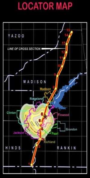
Volcano Under Jackson, Mississippi. Fair use of image via MDEQ Environmental News: Volume 5 Issue 7; July 2008

Residents of Jackson have little to worry about. The volcano hasn’t erupted for 75 million years and its been totally extinct for about the last 70 million years or so. The landscape was considerably different during those days, too. This was the late Cretaceous period when Tyrannosaurs Rex and many of the familiar dinosaurs we’ve all heard about roamed the earth.

A shallow sea covered a wide area of the modern-day central and southeastern United States, including most of Mississippi. Interspersed, there were several volcanic islands that rose above the seas in a rim-of-fire. The Jackson Dome, now buried and mostly unknown, was one of those islands.

Mississippi Coliseum, Jackson, Mississippi. Photo by Ken Lund; (CC BY-SA 2.0)
The Mississippi Coliseum

One would never wish to sit dangerously close to an erupting volcano. The worst place of all would have be directly above the crater where magma exits from the depths of the earth. If the Jackson Dome were ever to erupt, and of course that’s no longer possible, the Mississippi Coliseum would sit directly atop it (map). That almost seems a little ominous, doesn’t it? I can almost imaging the ash and dust instead of clouds, like the spirit of old Jackson Dome continuing to make its presence known.

Actually, it does make its present known, but not through volcanic activity. Massive amounts of carbon dioxide remain trapped beneath the surface, an echo of long-gone eruptions. Energy companies are able to harness the CO2 to force residual oil and gas from fields previously considered depleted. This has been so successful that even other countries have studied this model, including the United Kingdom for possible use in the North Sea.


Midnight Volcano

Welcome to Midnight. Photo by NatalieMaynor; (CC BY 2.0)
Midnight (Humphreys County), Mississippi

Jackson Dome isn’t the only late Cretaceous rim-of-fire volcano found in Mississippi, just better known because of its location. The other one is buried beneath the small town of Midnight in Humphreys County, Mississippi (map). It’s known appropriately enough as the Midnight Volcano. I like that name better but the above-ground features don’t offer quite the same dramatic effect as the Jackson Dome.


Posted

in

, , , ,

by

Comments

9 responses to “Jackson Volcano”

  1. Josh Avatar
    Josh

    I just want to know how we can get the Mississippi Coliseum to change its name to the Jackson Dome.

  2. Kalopin Avatar

    I’m wondering how someone in 1860 or 1819 would have discovered this volcano, being buried so deep underground? I’ve read that this volcano was called “Fire Mountain” by the natives and sat on what was known as “Jackson Island”,after Andrew Jackson?.I have also read, at an account by “Samuel Mitchell 1815” that there were stories of when the great earthquake took place in 1811 that “Fire Mountain had been rent to its base”[flattened] by this event. That would better explain the discovery, in a time when there was no ground penetrating radar and very few geologist, that they just must have known that it was already there. Is there a way to find if this information could be true?Thanks.

  3. Brad Avatar
    Brad

    Also the lake at Lefleurs Bluff State Park (just a few miles away from Coliseum) stays at 88 degrees year round.

  4. mw Avatar

    whu discoverd it

  5. Jack Avatar
    Jack

    The Jackson Dome was discovered by state geologist Eugene Hilgard in the 1850’s. Using elevation maps prepared by the railroad companies, Hilgard proved that a distinct layer of clay in Jackson sat at a higher altitude than the same layer of clay in Canton: a reversal of the elevations expected based on the uniform downslope trend of the Gulf Coastal Plain. Such an anomaly could only be explained by the Jackson area having been subjected to “some great upheaval in the ancient past,” he predicted.

    Hilgard did not name the Jackson Dome in his 1860 publication nor discover the volcano at its core. The latter would not happen until 1915 when exploratory wells finally went deep enough to bring up volcanic rock. Hilgard was the first scientist to publish empirical evidence of an anomalous geologic uplift at Jackson, and is thus credited with the initial discovery of the overall structure.

  6. kalopin Avatar
    kalopin

    Dear Jack,
    Why would they have always been referred to as standing volcanoes and never as calderas, even though they are now flat?

    How would an elevation map prove the existence of a volcano?

    Why would the volcanoes have nicknames, stories and legends?

    Why would natives have met settlers in Natchez Mississippi and tell them that burning Mountain next to the Wichita river had been rent to its base?

    Did the Jackson dome sit on an island named after Andrew Jackson?

    How was it found to have been buried 65 million years ago?

  7. C Avatar
    C

    Just because you think it’s not possible to erupt because it’s been dormant all these years doesn’t mean it will never erupt. All it takes is for the plates to open and if it’s in God’s will it will happen.

  8. Cindy Avatar
    Cindy

    Why colored like a heart? Is this the land elevations?

Leave a Reply

Your email address will not be published. Required fields are marked *

Latest Comments

  1. I am in La Libertad, El Salvador. Was absolutely astonished to see the sun rise at one end of the…

  2. Thank you for this information. I was searching “closest distance between towns of opposite elevations” and reveals zero results, at…

  3. I agree with a two mile run with admission proceeds go to the local Hancock schools in maryland doing it…

  4. Rock Springs Campmeeting is not the only one in NC. There’s also Balls Creek Campground, McKenzie’s Grove, and Mott’s Grove;…