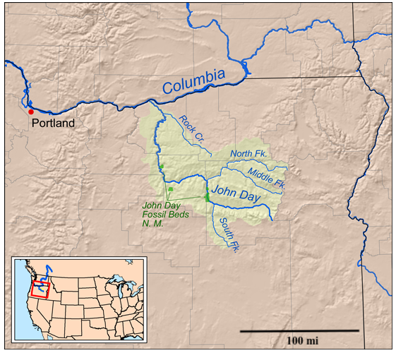
Bill Williams’ Fingerprints appeared on the Twelve Mile Circle about a year ago. Mr. Williams was “one of the classic mountain men of the old west”. His name carried forward to various geographic features throughout Arizona, as I noted at the time. This inspired longtime reader Pfly to comment, “This post makes me think about the John Day River.”
I tucked that thought away to explore another day. Now that day has arrived. It’s John Day’s day.

Like Williams, Day was an early trapper and explorer in the American West. However, he concentrated much further to the north, all the way into Oregon. He also had several geographic features named for him including the town of John Day in Oregon (map) along the John Day Highway.
Adventures
Day traveled through the west even earlier than Williams. He was already an accomplished mountain man when he joined the Astor Expedition in late 1810. This was the first American effort to establish a fur trading post in the distant west. Their goal was to establish a presence at the mouth of the Columbia River while preventing the British from doing the same.
The overland portion of this expedition discovered vital paths over the mountains that would later become key links in the Oregon Trail. This was all happening just a few years after the Lewis and Clark Expedition. So John Day was earning a living in the far western wilderness very early in U.S. history.
But the expedition ran into serious problems along the way:
“The party became divided and widely separated. Experiencing hardships, John Day’s group dwindled to two people. He and Ramsey Crooks eventually reached the mouth of the Mah-hah River along the Columbia. There, a band of American Indians took everything they had, including their clothes. They were rescued and reached Astoria (Oregon) in 1812, where he settled nearby. Due to this incident, people traveling along the Columbia River would point out the mouth of the river where John Day was robbed. By the 1850’s, the Mah-hah River was referred to and renamed the John Day River.”
John Day spent the rest of his life hunting and trapping in the Pacific Northwest. Historians believe that he was born around 1770 in Culpepper County, Virginia. He probably passed away sometime around 1819-1820 along the south bank of the Columbia River. However, researchers know little about Day other than his memorable adventures with the Astor Expedition.
John Day River

Getting to the mouth of the John Day River is considerably easier today than it was during the Astor Expedition. Interstate 84 passes directly above the John Day as it follows the Columbia River along the northern extremes of Oregon (map). It’s difficult to imagine the hardships John Day endured at this spot during that fateful expedition.

Other Places
Events occurring at the mouth of the river lent a name to its entire length and four branches. The river, then, lent a name to the town. It also provided a logical name for the John Day Fossil Beds National Monument:
“John Day Fossil Beds National Monument is a U.S. National Monument in Wheeler and Grant counties in east-central Oregon. Located within the John Day River basin and managed by the National Park Service, the park is known for its well-preserved layers of fossil plants and mammals that lived in the region between the late Eocene, about 44 million years ago, and the late Miocene, about 7 million years ago.”
This national monument is within a reasonable proximity to where I’ll be staying in Oregon this summer. I’ll add this to my list of possible places to visit.
Other places named for John Day include Dayville, OR (map), the John Day Dam on the Columbia River, and various smaller geographic points of interest throughout Oregon. That’s quite a legacy to commemorate a single event in the wilderness taking place two hundred years ago.
UPDATE: I did make it to John Day Fossil Beds National Monument in July 2012.

Leave a Reply