Google released its back catalog of Street View images recently, allowing users to understand locational changes since the introduction of Street View in 2007. I figured I’d let the hype die-down a bit and check it out.
Succinctly, I considered it an interesting novelty and probably not much more than that at the moment. So how many observable physical changes happened over the last few years at most locations? The real benefit will accrue as decades and then generations pass. Professional historians, and even armchair genealogists and aficionados like myself will discover increasing enjoyment as time goes by and the archive expands. I only wish I could see my great-grandparent’s home in southeast Washington, DC at the turn of the last century, for example, as it evolved over the years they lived there.
A Message To Readers in the Distant Future
That doesn’t exist of course. Right now Street View covers three fixed points in time at that location; 2007, 2009 and 2011. My descendants on the other hand will get what I wish I had for my ancestors. However, I will serve as the subject of their curiosity. Google’s imagery will become an historical treasure and assuredly a valuable collection within the National Archives even if Google morphs into something completely unrelated in the meantime.
Operating under a theory that somehow even Twelve Mile Circle will be captured and preserved for posterity within that same Google cloud, maybe I can give my great-grandchildren a head start on some observational elements. For even in my own tiny yard I’ve noticed ever-so-subtle changes over the last several years, and the Street View cars captured them faithfully in their glorious monotonous insignificance.
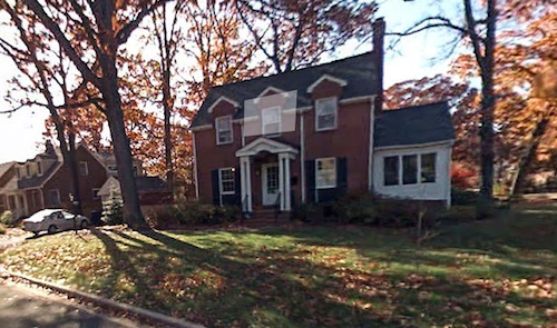
November 2007; Initial Street View Coverage

It seemed like I waited forever for Street View coverage to finally arrive in the Washington, DC area when I chronicled the roll-out with enthusiasm. The photos seemed grainy and blurry. Coverage was spotty. Nonetheless it represented a revolutionary idea. I could drive vicariously down a street I’d never seen in person and understand the neighborhood, its topography, its physical characteristics, and maybe what it meant to live there in a visual sense. We all remember the fan sites that sprouted soon thereafter with images of automobile accidents, of crack houses, of people caught in delicate personal situations and the like.
The new timeline feature brought back memories of the first images recorded at my home, an autumn day in November 2007. One can barely notice a twig sprouting on the right side of the foreground, a product of leaves already dropped for the winter plus poor camera resolution. That was a young Tulip Tree, Liriodendron tulipifera, a species native to eastern North America sometimes called a tulip poplar although it wasn’t closely related to tulips or poplars.
One day it simply appeared in the yard, a sprout less than an inch high with two tiny leaves. Ordinarily I would have pinched it with my thumb and forefinger and yanked it out as just one more weed to remove. My older son wouldn’t let me do that so I mowed around the pathetic stem very carefully all summer and it became “his” tree.
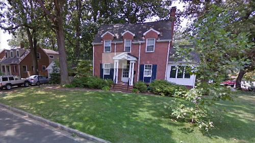
August 2009; Resolution Improves

Google evolved its technology by the time its car passed through my neighborhood again in August 2009, recording and posting much clearer imagery. The tulip tree started to seem like an actual tree. This species is noted for its quick growth and that’s confirmed after the passage of only two years.
It’s a very ancient type of tree related to Magnolia, extending back to the Lower Cretaceous period when Dinosaurs roamed the earth. Apparently tulip trees do best in the earlier periods of forest succession before other hardwoods start to block the sun and crowd them out. That was the exact niche it exploited on my lawn, a sunny spot with little competition.
I also noticed my old Jeep Cherokee in the driveway. My job moved back downtown to a different office. Public transportation became an option again on days I didn’t telework. I no longer needed it so I sold it.
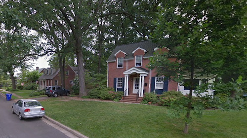
June 2012; Surmising an Exact Time and Date

Another couple of years passed, now jumping to June 2012, and the tree continued to grow. I noticed that this image had to represent a Thursday morning. See the blue recycling bin next to the curb on the left? Pickups always happened on Thursday. The bin had already been emptied and not yet returned to its rightful spot next to the house. That would make it early in the day.
Also the last of the blossoms remained on our late-blooming azalea shrubs and the upstairs windows were open. That signified very early in the month assuming Google’s June accuracy. I’m going to guess the car came through on Thursday, June 7, 2012 around 8:00-9:00 am.
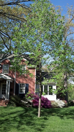
May 2014; Epilogue

Two more years ticked away. The Street View car should be expected to pass through once again anytime now. In its absence I went ahead and photographed the tulip tree yesterday although the new springtime leaves haven’t completely opened yet. The tree kept growing, actually quite an impressive amount over such a small number of years.
I wish I knew when Google would sweep through my neighborhood again. I’d make sure I stood outside waiving my arms for a fleeting moment of Internet glory. Does anyone have any Google connections? Certainly someone should be able to hook me up with a schedule given all of the geo-geeks in the 12MC audience. I’m afraid to even ask what I’d have to do to score a ride-along.

Leave a Reply