Today marks a special occasion on Twelve Mile Circle, with its first ever guest blogger, Matthias Gries from France. He has researched a couple of French geo-anomalies that fit in well with the spirit and content of this blog and has written a lively narrative to accompany it. I hope you enjoy his effort — I sure did!
Here are a few oddities from France, close to the Spanish Border
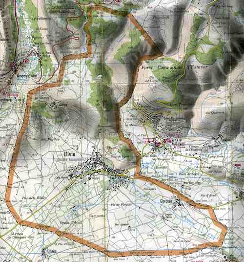
First, there’s Llivia (pronounced Libia), a Spanish enclave separated from the mother country and the nearby Spanish town Puigcerdà by just a few kilometers. I’ve taken some information from eric.hurtebis.chez-alice.fr/llivia.htm, but it’s in French.
Llivia

It’s an enclave because when France wanted to take this part of the country back from Spain, it was somehow said on the Treaty that they would take 33 villages. The thing is that Charles Quint [Charles V] had decided before to make Llivia a city, and not a village. France had been tricked. They tried of course to negotiate that but nothing worked. Llivia stayed Spanish.
Road Access
As you can see it, there’s a straight road linking the enclave with the rest of Spain. This road is supposed to be neutral. Actually, it’s Spanish all the way with a Spanish name and number, N-154, except for the small part that cuts across the D30 road, a French road (Spanish roads have a hyphen “-” between the alpha character and the number, while French roads do not). At the point of intersection they made this little crossroad (a traffic circle) and gave the roundabout a new French road designation: the D68. Now this might be the smallest road ever.
War of the Stops
It keeps getting weirder, or dumber. Just as the neutral-but-somehow-Spanish road leaves the “real” Spain, it crosses the French N20 road. Until a few years ago, no one wanted to stop for cross-traffic. French drivers were too proud to let a stupid little Spanish road cut through their own big road, and Spanish wanted to be able to go to Llivia without stopping for a French road (since they were going from Spain to Spain). This was known by a few as the “War of the Stops.” Rumor has it that citizens themselves were changing the Stop Signs from one side to another. We’re talking about real stupid here. This craziness ended with the construction of a viaduct in 1983 – actually it was the exact same problem with the D30 crossing, and the roundabout was built only in 2001.
And it isn’t over: apparently, there’s a French enclave within Llivia that includes a hotel with… a helicopter landing strip?! Knowing the mind of the people down there, that can’t be good. And it isn’t. It’s led to many lawsuits, the last one claiming the hotel will be a part of Llivia… in 2030. My head hurts, let’s go far away from that place.
Hendaye
Not so far away actually, since it’s still the Spanish/French border. We’re going to Hendaye, France just next to the Atlantic Ocean.
See this little piece of land?

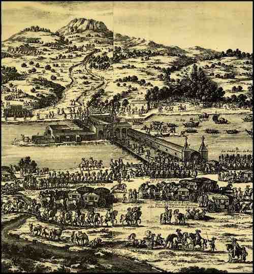
It’s called “Ile des Faisans.” It looks like it’s divided between France and Spain… kind of odd. But it’s getting odder: this piece of land changes mother country every 6 months. Sometimes France, sometimes Spain. It comes from the 17th century, when it was a bridge between the two countries.
Now the oddity makes proper sense.

The situation hasn’t changed since, even though the island is now completely uninhabited. I guess both of the countries are too proud to let go of a small piece of land.

Leave a Reply