Lowest Elevation in Nepal

This is Mount Everest (map), a topic way to obvious for the Twelve Mile Circle to consider. What could I add? Everyone knows about it, every map of the area shows it, and resources galore focus on its magnificence. Its national attitudinal opposite, however — the lowest elevation in Nepal — is a different story and a far more elusive quarry.

Mount Everest Panorama. Photo by Mike; (CC BY-SA 2.0)

Who cares about the lowest elevation in Nepal? Well I do, but that’s not a sentiment shared by many others apparently. Oh, it’s mentioned all over the Intertubes but most always just like this:

“The highest point is Mt. Everest (8848m) in the north and the lowest point (70 meters above sea level) is located at Kechana Kalan of Jhapa District.”

It’s an aside, a throwaway statement used to counterbalance the great weight of Mt. Everest, receiving little or no thought or original research. This statement, indeed this exact word-for-word recitation, replicates from website to website without care or concern. Doesn’t anyone believe in fact checking anymore, never mind using citations or avoiding the appearance of plagiarism?

I’ll give kudos to Nepal Monitor – the National Online Journal [no longer available on the Internet, unfortunately]. They buck the trend by setting the lowpoint at 67 meters. At least they seem to be using a different possibly more definitive, source. It doesn’t help me find the exact spot but it does give me some confidence of the general area of Nepal where it probably appears. I’ll withhold any kudos for the usually reliable CIA World Factbook though. They call it Kanchan Kalan, sending me on quite the wild goose chase for much of the morning.


General Layout

Let’s consider the topography of Nepal for a moment. Everyone knows about the Himalayas to the north. That’s a given. However, some readers may be a little surprised at the amazing drop in elevation as one moves south. A flatland runs along Nepal’s southern tier, straight down from Mount Everest.

Nepal topography: terai, foothills, himalaya. Photo by Inhabitat; (CC BY-NC-ND 2.0)

This is the Terai, a fertile alluvial plain of the Ganges River watershed that extends anywhere from 25 to 50 kilometers into southern Nepal. One generally conjures up images of trekkers and Sherpas when thinking of Nepal, but the Terai has more in common with Bangladesh: subtropical marshlands, grasslands and woodlands with exotic wildlife such as tigers, rhinoceroses and gharials (that’s a kind of a crocodile; I took a picture of one at a zoo a few years ago if you want to see what one looks like)


The Jhapa District

Let’s take a closer look at the Jhapa District at the southeastern corner of Nepal, and see if we can identify the elusive Kechana Kalan.
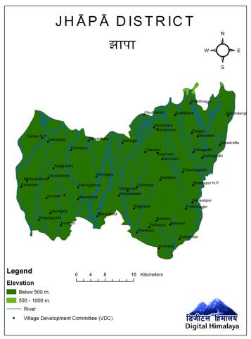
Jhapa District of Nepal. Fair use of copyright image from Digital Himalaya

I find lots of fascinating websites as I research these posts. In this case the map comes from an interactive tool available at Digital Himalaya, “A project to develop digital collection, storage, and distribution strategies for multimedia anthropological information from the Himalayan region.” I had a lot of fun generating all kinds of maps of Nepal as I searched through the options.

Another useful resource was a site called “Revolution in South Asia” which was the only place that I could find a really detailed map of Nepal online. I began to narrow down the location of Kechana Kalan by cross-referencing these resources and by examining the Jhapa District.
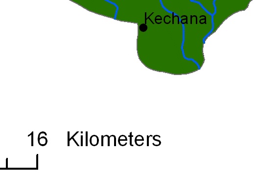
Kechana in Southeastern Nepal. Fair use of copyright image from Digital Himalaya

I found a town called Kechana by looking at a detail from the Jhapa District from the same map. Is this the fabled Kechana Kalan? Honestly, I don’t know. It does have a number of possibilities going for it though, including its name and approximate location. Maybe I’m being too literal, too. Maybe the lowpoint is an area rather than a distinct “spot” given the relative flatness of the surrounding terrain.

Much like the trekkers who nearly make it to the top of Mt. Everest but have to turn back, I have not been able to completely determine the exact longitude/latitude of Nepal’s lowpoint and I must give up the chase for now. I think I got close but I’m missing the last piece of evidence that would nail it down. Maybe next blogging season.

Hopefully someday a Nepalese geographer will stop by to solve this mystery.


Posted

in

, ,

by

Comments

8 responses to “Lowest Elevation in Nepal”

  1. Craig Avatar
    Craig

    It appears that the “Kalan” part may mean “great”. For instance, the Pamir mountains appear to be divided into the “Pamir-e-Kalan” (“Great Pamir”) and “Pamir-e-Khurd” (“Little Pamir”). No guarantees that that’s right, but it appears to be a start.

    1. Twelve Mile Circle Avatar

      Thanks for the good clue, Craig. We may now be one step closer to solving the mystery!

  2. aletheia kallos Avatar

    perhaps you are closer to your trypoint just by virtue of trying

    this topo
    http://www.lib.utexas.edu/maps/ams/india/txu-oclc-6614190-ng45-7-cop.2.jpg
    suggests the location you have identified is impossible
    because the stream shown there continues downhill within nepal
    &
    that there are 3 more likely locations
    at the 3 southernmost extremities of nepal shown on it

    each of these locations is on the thalweg of a river as it passes into india
    but they are all so close in elevation to one another
    that they most probably alternate as national lowpoint
    depending on the vagaries of local rainfall & snowmelt

    a mouse probe at google earth suggests the likeliest of these points is the one at about elong 87d20m
    where the altitude appears to fall to 61 or 62 meters

    cheers

    1. Twelve Mile Circle Avatar

      I’m honestly overwhelmed by the helpfulness of this series of comments. The posts I enjoy the most are the ones that create discussions I never anticipated, that lead readers (including myself) on new journeys. I’d put this one right up there with all the fun we had discussing east coast sunsets and west coast sunrises over water several months ago.

      What you’ve taught me:

      • A few introductory words in the Nepalese language
      • A better understanding of Nepal’s civil structure
      • A source for an even more detailed map of Nepal; and
      • (drumroll, please) – A means to find the probable lowpoint

      I think I replicated Aletheia Kallos’ Google Earth search. Here is one such location. This puts the spot just a few kilometres away from where I focused initially.

      I agree that the actual lowpoint probably varies depending on water levels and weather conditions. It’s probably not a static spot that one could mark with certainty. Even so I’d guess that it would likely move no more than a kilometre or two from this target judging by the topography.

      Well done, everyone!

  3. Richard Avatar
    Richard

    I have a co-worker who is from Nepal, and he confirms that the lowest point is in the Kechana VDC (village development committee, small admin boundary like a county) in the area you identified. Although he is unsure as to the exact location. So you are in the right area.

  4. Nick Matyas Avatar
    Nick Matyas

    Very nice posting. I liked it.
    thank you for your great posting.

  5. Richard Avatar
    Richard

    Nice man Thanks i cheated from your site for my school homework answers!!! Thanks!

  6. Patrick O. Kane Avatar
    Patrick O. Kane

    I encountered your work while trying to pin down the true height of Mt. Everest; referring to vertical base to peak measure. In some sources I see 8848.86 m identically as Elevation and Prominence. Which I interpret prominence as the measure of height I wondered about. However I find it somewhat a wonder to believe Mt. Everest is deemed to be measured as based at Sea Level. Can you comment on your searches and interest on that question??
    Thanks — Patrick

Leave a Reply

Your email address will not be published. Required fields are marked *

Latest Comments

  1. Osage Orange trees are fairly common in Northern Delaware. I assumed they were native plants. As kids we definitely called…

  2. Enough of them in Northern Delaware that they don’t stand out at all until the fruit drops in the fall.…

  3. That was its original range before people spread it all around. Now it’s in lots of different places, including Oklahoma.