U.S. Fish and Wildlife Service’s Endangered Species Program uses maps extensively. In turn, this helps website visitors conceptualize the imperilment of specific animals and plants within their area. The primary visual interface comes through their Threatened and Endangered Species System (TESS).
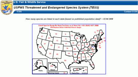
It lets users sort data stored in the system by various criteria, including by State. The resulting image — displayed in the screenprint below — is one result. It provides the number of endangered species for each State and allows users to select from among them.
Overall Map

Unfortunately, distressed animal and plant populations are all too common. The initial geographic representation makes this point abundantly clear. Even the tiny District of Columbia has six animals and one plant included on the list. However, admittedly, residents of this very urbanized setting might not mind all instances. Eastern Puma returned in large numbers to Rock Creek Park might make people a little nervous.
Individual Profiles
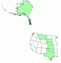
So users select a state by name. Then they arrive at a list of endangered animals and plants for that locale. From there they link to individual pages for each imperiled organism. Individual species profiles contain further details on regulatory status, recovery, critical habitat and conservation plans. Many of them include a general habitat map.

For instance, the Eskimo Curlew (Numenius borealis) lives in Alaska. It also follows a migratory route through the central United States including the Rio Grande Valley National Wildlife Refuge.
Poking around the website a bit further produces any manner of interesting maps and facts. These include the Little Mariana Fruit Bat (Pteropus tokudae) of Guam, the Kuenzler Hedgehog Cactus (Echinocereus fendleri var. kuenzleri) of New Mexico, and hundreds of other imperiled flora and fauna found throughout the States and its territories.

Leave a Reply