Three cheers for longtime reader Pfly for pointing out the Merrick Strip in a recent comment. Did you miss the comment? Are you wondering what I’m talking about? Then check out the northwest corner of Merrick County, Nebraska.
Notice what almost looks like an antenna protruding from the main body of the county. It’s an odd appendage that rises due north for nine miles. Merrick is full of strange boundaries. A knob rests atop the northeast corner. A chunk of land sits on the “wrong” side of the Platte River, probably signifying a change in the river course somewhere in the past. However, it’s that narrow sliver that rises to the top of the geo-oddities list.
Mapping the Strip

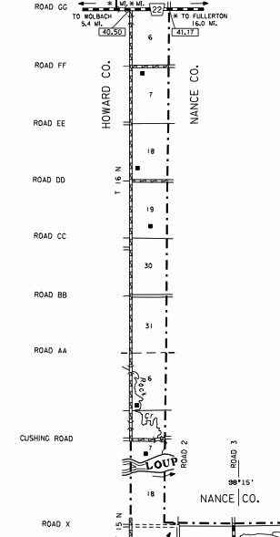
I found an even more precise map provided by the Nebraska Department of Roads. The distance running north conforms to what one would expect in the Public Land Survey System township/range model. The width is quite unusual. It includes nine complete sections stacked atop each other like blocks. However, the width of each segment seems to be only 2/3 of a mile (notice where the strip attaches to the rest of the county and compare to the section structure found there). Sections generally split into halves – e.g, half section, quarter section, and the like. Something based on thirds is a bit strange.
I’d like to be the guy who lives at the tip of the strip. Different counties hem him in on three sides. Howard County abuts him to the west and Nance County to the north and east. I love the way he’s positioned a center-pivot irrigation device on his parcel. The pivot is wider than the parcel so he can’t quite make a complete a circle. He lopped off the edges on three sides to wedge it in to the parcel (map)!
I was hoping that this might also be a practical exclave. However, it doesn’t appear to be the case. This Street View image peers from the Howard-Merrick-Nance tripoint back into the tip of the Merrick County strip. Notice the dirt road heading south towards the horizon. It rides the spine of the Howard-Merrick boundary for nine miles to the main body of Merrick County, providing a razor-thin means of public access.
Origin
The unusual shape hasn’t gone unnoticed. Therefore its origin is pretty easy to determine as a result. A small booklet compiled in 1958 in recognition of Merrick’s 100th anniversary provided one of the better descriptions.
“With a “panhandle” about 200 rods wide and nine miles long extending up between Nance and Howard Counties, Merrick is one of the most peculiarly shaped counties of Nebraska. There is another panhandle, 5 1/2 miles wide and six miles long at the northeast end of the county, Most of the northern boundary is a series of jogs, and very little of it coincides with section lines, and much less, township lines. The county line cuts across farmers’ fields in more cases than not.”
The strip came about through a rapid series of events during the mid Nineteenth Century. I used the above source plus my favorite Atlas of Historical County Boundaries and various other online references to create a basic timeline.
- 1854: Nebraska became a territory. County structures began to form
- 1857: the U.S. Government established a reservation for the Pawnee Indians along the Loup River in Nebraska
- 1858: Merrick County formed. Its northern border consisted of a straight line running directly through the Pawnee Reservation; so the southern half of the Pawnee land then fell within Merrick Co.
- 1867: Nebraska became a state
- 1874-1876: Nebraska exercised its state powers, seized and sold the reservation lands, and used the funds to relocate the Pawnee Indians to Oklahoma
- 1879: Nance County was formed from the former Pawnee reservation. Merrick’s northern border changed to its current peculiar form
Once again the story involved a broken treaty with a Native American tribe. As often the case, the Pawnee Nation got the poor end of the bargain. However, it didn’t explain why the western edge of Merrick County failed to conform to the border of the Pawnee Reservation upon its establishment. Why were they 2/3 of a mile out of alignment?
One Possible Explanation
So I have a theory. Let’s consider that many of Nebraska’s internal borders were forming, moving and reforming at a frantic pace in what amounted to a four-year period, 1854 through 1858. Imagine a scenario where the boundaries of the Pawnee Reservation were laid-down hastily. The following year surveyors would have come through the area a second time to mark the western edge of the newly-formed Merrick County. It clearly coincided with the township grid along with other counties forming at the time.
If there was an error it wouldn’t really matter because the southern half of the reservation fell within Merrick regardless, and Nebraska probably wouldn’t want to hand-over ownership to the Indians anyway. We’ve seen that state boundaries formed during this period deviated by similar distances so it’s not so strange to consider that it might also happen at the county level too.
Merrick abruptly lost 180 square miles in 1879 when the remnants of the reservation were lifted from its borders by the state government. Would anyone really blame Merrick for holding onto their narrow strip? I don’t know if that’s the actual reason but I do know that people hate to lose land. Has anyone found the real story?

Leave a Reply