Mob Rule

One dictionary defines mob rule as a government by violent gangs, or by the masses. Another provides a wonderful synonym, Ochlocracy, a middle French word derived from the ancient Greek; which various other sources define as power from the multitude or crowd. Either way it seems a strangely deviant name for a website devoted to the exceedingly orderly and ordinary practice of County Counting.

The Mob Rule Website has nothing to do with anarchy as it turns out, and everything to do with a play on the author’s name. It would be as if I called my site T-HO instead of the Twelve Mile Circle. Some of us are lucky enough to have initials that work for that purpose, some of us like T-HO, not so much.

You know all about the practice of County Counting if you’ve been following this blog even semi-regularly. You’ve even heard me mention the Mob Rule website. The hobby involves nothing more than keeping a running tally of every county you’ve visited. You define what a “visit” means. You also define the geographic unit. If U.S. counties don’t do it for you there’s always Canada, Ireland, the UK, France, wherever. If you want to broaden the scope to an international level, well that works just fine too. It can lead to all sorts of bizarre behaviors like hours-long detours along rural country roads for the sole purpose of collecting a few new counties.
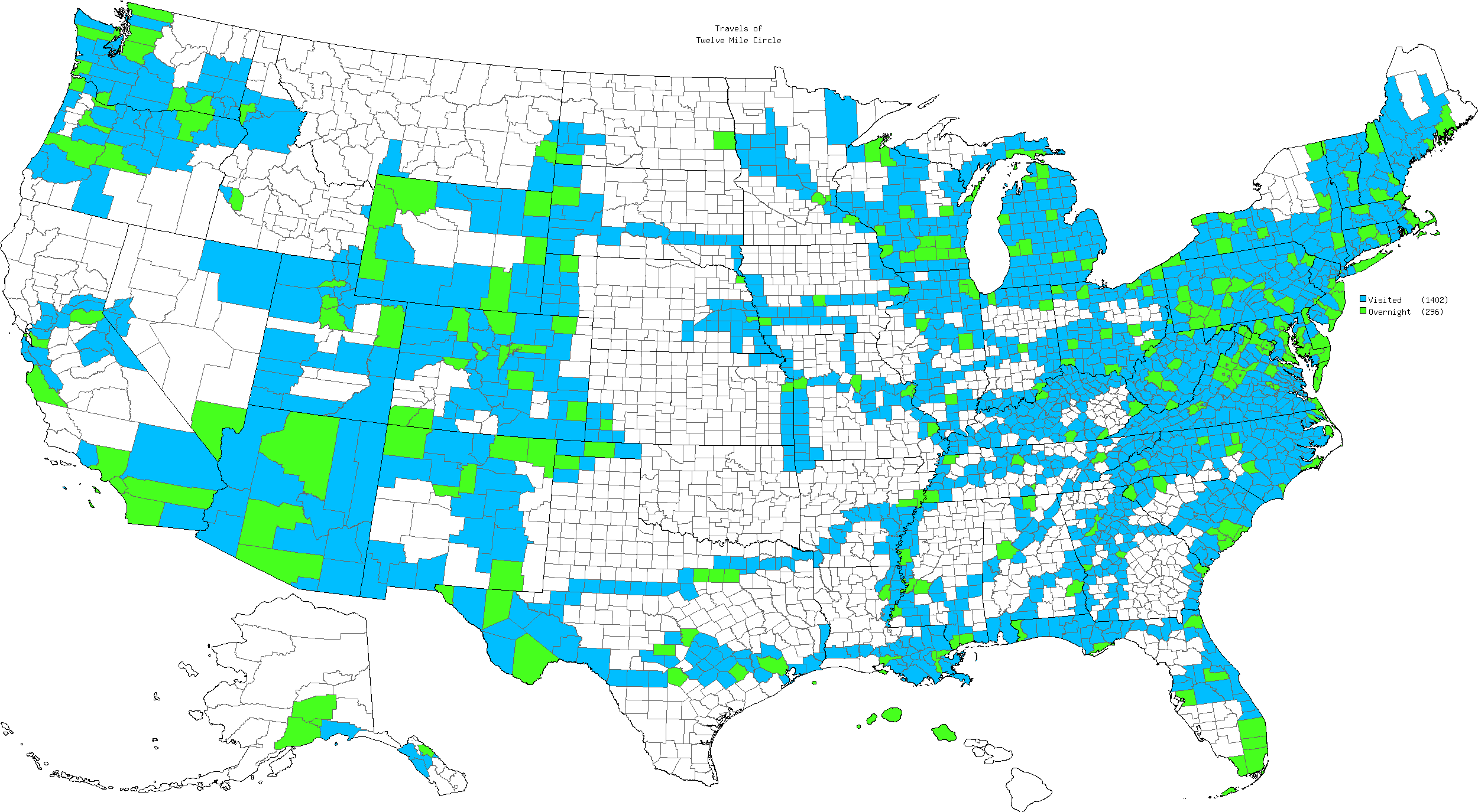
Counties in the United States that I have visited.

I talk about County Counting often because I enjoy it. I practiced it long before I even knew it was a common phenomenon in the geo-geek world. In other words it’s not a common phenomenon at all, but it does serve as a gateway leading to the conversion of many a geo-curious bystander into a card-carrying aficionado.

The Intertubes are nothing if not a means for small communities to identify themselves and coalesce. County Counters are no different and Mob Rule provides electronic tools to help those people follow their pursuit. It may not look like much on the front page but it is great fun once you understand the site and start using it.

Readers have sometimes asked why I don’t have a Mob Rule account. I’m not much of a joiner, as I explained in my earlier post. Also I’m lazy. Really lazy. It never seemed to make it on my list of priorities. Well, that’s changed and that’s the entire reason behind this post: I finally requested an account and I’ve begun to load my counties. I’ll probably finish it over the weekend. I blame it on loyal reader Mike Lowe who always includes his Mob Rule *.gif in his comment tag (just kidding).

My account is “12mile” and this is my work-in-progress map. I’ll probably keep the map on my personal website up-to-date because I use it for other purposes but it’s always nice to have a backup site and a means to compare progress with like-minded individuals.

Hey, I always reserve the right to be a hypocrite to change my mind.


Posted

in

,

by

Comments

7 responses to “Mob Rule”

  1. Craig Avatar
    Craig

    I’m wondering how much hiking/biking the Appalachian trail might fill in some of the East Coast gaps.

  2. Mike Lowe Avatar

    Until recently, my mob rule website was my only current presence on the web. Therefore I used it. It’s still better than the Facebook page my wife made for me.

    When my county map is my office computer wallpaper, coworkers and clients comment. Some of them now have pages at mob rule. It’s easy to use. The detailed border and travel route research brought back a lot of memories.

    “12mile” eh? That sounds a lot like “8 mile”. No rapping please. 🙂

    1. Twelve Mile Circle Avatar

      @Mike Lowe: my musical ambitions were cut brutally short, and deservedly so I might add, and fortunately for the world at large involved NO rapping. The "mile" system of roads in the Detroit area from which the whole 8 mile thing derived, by the way, is an interesting geo-story in its own right. I’ve thought about featuring it a couple of times but for now it still sits on the big list of potential topic.

      @Craig: I might have to put together just such a map, not that I’m in any shape to actually hike the AT.

  3. pfly Avatar

    It occurs to me that this county counting thing is biased toward people living in the east, at least for people seeking to achieve high counts. Since counties are generally smaller in the east–often much smaller–it is easier, even unavoidable for one to pass through more during a road trip in the east than in the west.

    So I made a map for counties I’ve been to at mob rule. It’s not quite perfect, but close: http://www.flickr.com/photos/pfly/4649018016/

    In terms of area the map looks fairly close to yours, but my total count is 726 while yours is 1,053. Then again, my map has a lot of area in the west where the counties are large, sometimes huge. I’ve driven across Wyoming, for example, many times via a number of different routes, but it still adds up to just 14 counties (and I’m not quite sure about 2 of them). Meanwhile, a few trips from, say, Baltimore to Chattanooga (approximately equal distance to a trip through Wyoming) could easily add up to over 100 counties.

    Anyway, I don’t have a point per se, just an observation. There’s quite a few western counties that are larger than quite a few eastern states!

    1. Twelve Mile Circle Avatar

      @pfly: Oh, it’s horribly biased from a numerical standpoint. I mean, look at my situation in the Commonwealth of Virginia where we have nearly 40 independent cities and each one is considered a county equivalent. One of those — Falls Church — is only 2.2 square miles, and it "counts" exactly like those western counties that are larger than some eastern states. I can barely walk out my front door without knocking into a bunch of different jurisdictions. But eventually I’m going to have to go out and collect those really tough, really large, western counties that you already have under your belt and that’s where you’ll pass me.

      I did notice on your map that you have Washington, DC marked as a standalone catch. Assuming you didn’t arrive by helicopter or ship (both theoretically possible) and instead came by commercial airline, you have at least one more county to add. National Airport on the Potomac River is actually in Arlington County, Virginia. If you arrived at Dulles Airport and took the Dulles Access Road to DC you hit Loudoun, Fairfax and Arlington Counties.

      See, you’re catching up to me already! 😉

  4. pfly Avatar

    I added DC because I clearly remembering being there as a kid. I have no recollection of getting there or leaving. I know we drove, but since I don’t remember the trip I figured I shouldn’t count it.

  5. Mike Lowe Avatar

    Due to this bias issue, I prefer to think in terms of the percentage of counties of a state I have visited. I am highest in percentage in DC (easy), TX, UT, and CO,

    The small size and large number of Virginia counties (including independent cities) makes them easy to miss. During our trip to the Appalachians in 2005 (before I counted counties), my wife ad I ate dinner at a restaurant just outside of Lexington, VA. We didn’t drive into the independent city. I get to count the surrounding Rockbridge county but the city will have to wait until another trip.

    Nowadays I look at county lines when planning trips.

Leave a Reply

Your email address will not be published. Required fields are marked *

Latest Comments

  1. Osage Orange trees are fairly common in Northern Delaware. I assumed they were native plants. As kids we definitely called…

  2. Enough of them in Northern Delaware that they don’t stand out at all until the fruit drops in the fall.…

  3. That was its original range before people spread it all around. Now it’s in lots of different places, including Oklahoma.