I noticed an anomaly as I pulled together the spreadsheet of every county named for a U.S. president for the recent Last Presidential Counties article. There was a single Millard County. It represented the only county designated for a president’s first name rather than his surname. Well, as far as I could determine. It got stranger. Millard County, Utah had its seat of government in the town of Fillmore.
Obviously someone wanted to honor President Millard Fillmore. So the county picked up his first name and the town adopted his last name. That would be like establishing a Richard County with its local government in a town called Nixon. Of course that assumes someone will name something significant for Nixon. If anything the whole thing seemed backwards.
However, something went awry. Fillmore should have been Utah’s state capital instead of Salt Lake City and then it would have made perfect sense. The weird imbalance would never have existed. Instead, Millard County remained rather obscure with barely 12,000 residents. Thus it offered 12MC an excellent opportunity to fill a blank spot on the Complete Index Map.
Territorial Statehouse

Millard Fillmore wasn’t exactly the most towering icon of presidential history. In fact, he falls consistently near the bottom of the pile by historians who tracked such things. He just happened to be president at a convenient time for him to benefit from some good-old-fashioned political pandering. It was an expedient choice:
“Why Fillmore? Location (geographic center), location (water, land), location (wood, stone). After congress set the boundary and created the Territory of Utah in 1850, Brigham Young, as the newly appointed governor, chose a suitable location for a capital. This location, near the geographic center of the territory, had all the needed resources to build with, and was located on the major travel route. Brigham Young designated it Fillmore City and Millard County to honor the United States President.”
Construction began on the new Capitol building and the Territorial Legislature met there in 1855 (map). They only ever finished the south wing. The project failed due to financial difficulties. Then the Territorial Capital moved to Salt Lake City a couple of years later. The old partially-completed Capitol is Utah’s oldest intact government building. Today it stands at Territorial Statehouse State Park.
Fort Deseret

Millard County did retain some significance in the early history of Utah. Also, Mormon settlers continued to move into the Pahvant Valley. However, this created ongoing tensions over land and resources with Native inhabitants including the Ute and Paiute. This contributed to a conflict known as the Black Hawk War.
“The years 1865 to 1867 were by far the most intense of the conflict. Latter-day Saints considered themselves in a state of open warfare. They built scores of forts and deserted dozens of settlements while hundreds of Mormon militiamen chased their illusive adversaries through the wilderness with little success. Requests for federal troops went unheeded for eight years. Unable to distinguish ‘guilty’ from ‘friendly’ tribesmen, frustrated Mormons at times indiscriminately killed Indians, including women and children.”
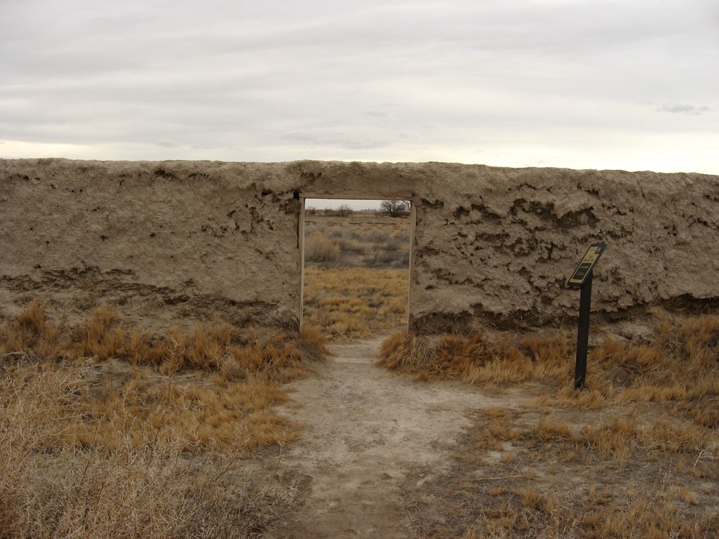
Local residents constructed Fort Deseret (map) as a defensive measure in 1865.
“In desperation the settlers sent word to President Brigham Young who authorized them to built a fort. As teams of men were chosen to build the fort, it was decided a contest would help encourage speed in erecting the defensive structure. The winners were to be recipients of a supper and a dance, while the losers had to furnish the food and entertainment… The fort was completed in 18 days by 98 men. It was 550-feet square with bastions at the northeast and southeast corner, and portholes giving a view of each side. The fort was never used for its primary purpose, but instead housed the livestock each night.”
No other Adobe fort from this era of Utah history exists today. Even this site will eventually crumble back into the valley floor as it slowly erodes away.
Topaz War Relocation Center
Millard’s obscurity pushed it towards the forefront during a later historical era, during the Second World War. This became the site of the Topaz War Relocation Center, an internment camp for Japanese Americans.

It’s a shameful chapter of American History. War hysteria and fear led to the relocation and internment of 120,000 people of Japanese descent from the west coast of the United States to various inland camps. Approximately ten-thousand of them, primarily from the San Francisco area, ended-up at Topaz for the duration of the war. Topaz didn’t close until late 1945. The outline of the Topaz Relocation Center remains etched on the landscape. Only memories remain today; many preserved at the Topaz Museum.
An official Presidential apology wasn’t issued until 1991.

Leave a Reply