Geo-Oddities of Portland, Oregon

Every once in awhile I’m honored to share content or even an entire guest post written by a loyal Twelve Mile Circle reader. We are very lucky today. Marc Alifanz contributes his expert knowledge of Geo-oddities in Portland, Oregon. Marc is an experienced blogger both in his professional and personal life and as he demonstrates below, has a keen interest in geographic features both magnificent and unusual. He invites the 12MC community to add any other Portland oddities that you may know about. Thank you Marc for this incredible post.

Take it away, Marc…
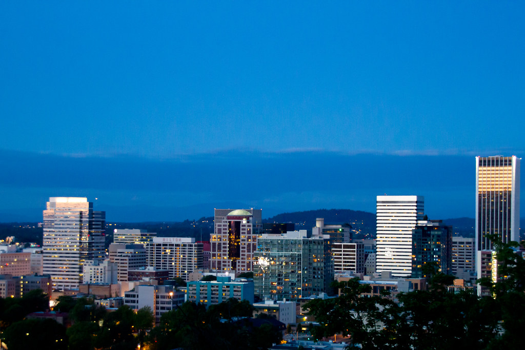

Portland Skyline. Photo by Razvan Orendovici; (CC BY 2.0)

I’ve been living in Portland, Oregon for about five years, and since I’ve been reading Twelve Mile Circle I’ve occasionally had the thought that a post on my new home town would be an appropriate and interesting post for the site. Here’s a list of some of the geo-oddity or geo-historically interesting features of Portland that I’ve come up with.


Wilderness Parkland

Portland is reputed to have the largest wilderness park inside a city limits in the United States. Forest Park is a lot of old growth or second (but still very old) growth that covers 5,100 acres in the West Hills of Portland, with a vast array of hiking and biking trails.


Smallest Municipal Park

Portland also has the smallest municipal park in the world. Mill Ends Park has a diameter of 2 feet and is an officially recognized city park downtown along Naito Parkway, which runs along the Willamette River. I drive by it every day on my way home from work, and the shrubbery frequently changes, sometimes in very amusing ways.


Extinct Volcano

Portland is one of only three cities in the United States with an extinct volcano within its city limits. Most people here say it’s the only one, but Wikipedia knows better. Mt. Tabor on Portland’s east side is an extinct volcano and city park. Hiking through the park you can walk in and around the long extinct caldera, which is pretty awesome. Mt. Tabor Park also houses a good portion of Portland’s reservoir system, which is one of the only open air systems of its size remaining in the US. The history and drama of the reservoirs alone could fill a book.


Active Volcanoes

Mount St. Helens Smoke. Photo by Marc Alifanz; all rights reserved - used by permission.
Mount St. Helens Smoke

Four active or potentially active volcanoes can be seen from inside the Portland city limits, which has to be a record of some sort. This is fairly incredible when you think about it. On a clear day, from various points within the city limits, one can see Mount Hood, Mount Adams, Mount St. Helens, and a very distant but still visible Mount Rainier. We are lucky enough to be able to see all four from our house on a clear day. My wife and I often rate the weather by the number of volcanoes we can see at a time. (“Good morning hon, looks like a 3 mountain day today.”)


More Than Four “Quadrants”
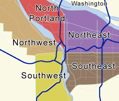
Map of Portland, Oregon. Image by Sean Kelly; (CC BY-SA 3.0) via Wikimedia Commons

Portland is split into quadrants, but that apparently wasn’t enough. All streets in Portland have a quadrant designation. The north-south boundary line is Burnside Street. The east-west boundary is the Willamette River. All addresses carry a NW, NE, SW, or SE designation…except…just north of downtown, the River turns toward the northwest. To keep the numbering system consistent on a north-south basis east of the river, the city planners carved out a “fifth quadrant,” which carries a plain old “North” designation. Also, there is arguably a sixth/seventh quadrant because addresses along Burnside Street, the north/south border are considered neither north nor south, and carry just an E or W designation. Also, unknown to me until writing this, there is a “hidden” quadrant in SW.

On the west side south of downtown, the RiverPlace, John’s Landing and South Waterfront Districts, which are all relatively new construction, lie in an area where addresses go higher from west to east toward the river. East-West addresses start with a leading zero. For example, this means 0246 SW California St. is different from 246 SW California St. While not technically a new quadrant (it still carries a SW designation), it is a unique deviation from the established numbering system.


Inspiring The Simpsons

The Simpsons: maybe not a geo-oddity per se, but a fun game for Simpsons nerds. On the west side of the river, starting with Burnside Street and moving north, all the streets start with subsequent alphabet letter…i.e. Burnside, NW Couch, Davis, Everett and so on up to NW Wilson Street. What everyone in town knows is that these streets serve as the names for various Simpsons characters, including, Burns (Burnside), Flanders, Lovejoy, and Quimby.

What many locals don’t realize is that there are several other hidden streets/cities around Portland that serve as Simpsons’ names. One of those is SW Terwilliger Blvd, which is the basis for Sideshow Bob’s last name, and also, the Montgomery Park building in NW Portland serves as Mr. Burns’ first name. The one I think very few people know about is N Van Houten Street, which inspires the last name of Bart’s friend, Millhouse. I’m guessing there may be others hidden around town I have yet to discover.


Beer

Also not a geo-oddity, but of possible interest is that Portland has the highest number of micro-breweries per capita of any city in the country. [editor’s note: 12MC heartily approves]


Coin Flipping

Uncertainty. Photo by the Nicu Buculei; (CC BY-SA 2.0)

Portland was originally founded by Asa Lovejoy from Boston, Massachusetts and Francis W. Pettygrove of Portland, Maine. Each wanted to name the new town after their place of origin. They flipped a coin, and Portland won. It’s probably a good thing it worked out that way, because two Bostons of very large size would have created more confusion than big Portland, OR and littler Portland, ME do now.


Nearby Geo-oddity: Sauvie Island
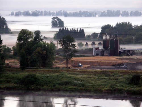
Morning fog over Sauvie Island. Photo by Marc Alifanz; all rights reserved - used by permission.

This is one that is close to my heart, because I live just next to the only bridge providing access to Sauvie Island, which is unique in and of itself. The southern end of the island sits about a mile north of the Portland city limits. The south end sits in the Willamette River, and the part of the river that routes to the west of the island forms the Multnomah Channel. The Willamette River continues along the east side of the island where it empties into the Columbia River. The Multnomah Channel then empties into the Columbia some 15 miles further north by St. Helens, Oregon.

It’s a big island. Bigger than Manhattan. So big, in fact, that it constitutes the largest river island in North America, and the second largest freshwater island in the United States after Isle Royale in Lake Superior. The island is also steeped in history, dating back to 1792. Now it serves as an agricultural area (we buy all our produce there), a wildlife preserve, and has great sandy beaches along the Columbia on its northeastern shores. Although apparently safe enough for swimming, I don’t plan to go in given that it’s just downstream from about 50 Superfund sites (possibly the inspiration for Blinky on the Simpsons?).


Nearby Geo-oddity: Columbia River Gorge

Multnomah Falls. Photo by howderfamily.com; (CC BY-NC-SA 2.0)

Nuff said about this unbelievable and unique geographical formation, formed by the incredible Missoula Floods (which are also responsible for the extremely rich Willamette Valley soils), which houses some of the most amazing waterfalls and quasi-rain forests in the northwest including Multnomah Falls, the third tallest year round waterfall in the United States. Also, the Gorge is responsible for a large amount of Portland’s occasional snowfall, as it essentially acts as a wind funnel, shunting cold high desert air from the east in a westerly direction toward the Willamette Valley, and dropping the temperature just enough in Portland’s always rainy winter to make snow or ice. When I want to impress out of town visitors to Portland, this is where I take them.

Comments

19 responses to “Geo-Oddities of Portland, Oregon”

  1. Joe Avatar
    Joe

    Looks like the microbrewery claim may have some competition:

    http://www.southernliving.com/travel/southern-microbreweries-00417000067296/

    I decided to try to take on the challenge of determining which city has the true claim. The southernliving article above claims Asheville has 10 breweries. With a 2010 census population of 83,318, that means Asheville has a brewery for every 8,332 people.

    In the other corner, we have Portland. The Oregon Brewers Guild (http://oregonbeer.org/portland-metro/) lists 61 breweries that have a Portland address. I did not take the time to verify if all 61 are actually in the city limits, so it is possible this list is not completely accurate, but I digress. Oregon’s 2010 census population is 583,776. The result is a brewery for every 9,570 people.

    Therefore, my completely unscientific winner is Asheville.

  2. Peter Avatar

    I believe Portland’s seaport is the largest fresh-water seaport in the United States and one of the top few in the world.

  3. Samuel John Klein Avatar

    I want to credit Mark for having such a sharp eye. For only being here in PDX five years, he’s already amassed himself a wealth of local color that credits him well … most people live here years and don’t even bother!

    I myself have been obsessed with Portland’s geography since I was little. I’ve collected many maps about Portland and can recommend a book, “Portland Names and Neighborhoods, Their Historic Origins”, by Eugene E Snyder. It’s a small-press book published by the local publishers Binford and Mort, and may be out of print, though copies may be available on Amazon. A Rosetta stone for anyone wanted to know the how and the why of the Portland street name system

    I myself have an article or two on my own blog that may be of interest to the readership here, if it’s not to gauche to toot one’s own horn. I analyzed a 1928 Map of Portland – one which happened before our current street naming-and-numbering system was inagurated – here:

    http://zehnkatzen.blogspot.com/2008/09/portland-address-system-in-1928.html

    And I have one of my own writeups on the “zero-hundred” district here:

    http://zehnkatzen.blogspot.com/2005/07/geography-address-nerd-on-zero-hundred.html

  4. Pfly Avatar
    Pfly

    There seems to be at least one other US city with an extinct volcano other than Portland and Bend: Honolulu includes Diamond Head, an extinct volcano. In fact, due to the city of Honolulu being consolidated and identical to the county/island of Oahu, there are apparently quite a few extinct volcanoes. Another example, it seems, is “Punchbowl Crater”, which Wikipedia says is in Honolulu. I can’t think of any others offhand, but I’d bet there are other US cities with extinct volcanoes, or at least ancient cinder cones and the like. Hmm, maybe Rexburg, Idaho, of which Wikipedia says, “Much of Rexburg, including BYU-Idaho and the Rexburg, Idaho LDS Temple, rests on top of a shield volcano just north of Rigby, ID.”

    1. Scooby Avatar
      Scooby

      There is an extinct cretaceous era volcano under the campus of St. Edward’s University in Austin, TX- it is wholly within the city limits. There is another outside the city limits that is larger.

  5. Pfly Avatar
    Pfly

    Oh and, whenever I read about “largest this”, “only that”, etc, it feels like a challenge. So seeing Sauvie Island called “the largest river island in North America” (at 32.75 sq miles, according to Wikipedia) makes me want to find a bigger one. For a minute I thought I had an example with Grand Island, NY, but it seems to be a few square miles smaller after all. I’m having some trouble finding info on the size of Lulu Island, near Vancouver BC, but it seems to be about 94 sq miles. There’s also the Island of Montreal, at about 190 sq miles.

    The bit about being able to see, under the right conditions, 5 active volcanoes–and really huge volcanoes too–is definitely one of the things I like about Portland–although I’ve never been able to see Rainier from there, but I haven’t tried too hard. Up here in the Seattle area you can see three–Rainier, Baker, and, if you’re in just the right spot, Glacier Peak. Anyway, nice to read about Portland’s oddities, one of my favorite cities.

  6. Pfly Avatar
    Pfly

    Ok, one more before bed. I can’t help but start researching when seeing superlative claims! I found several river islands in Canada larger than Sauvie (Sauvie being between about 33 and 41 sq mi, depending on how you measure): Island of Montreal of the St. Lawrence, Quebec (190 sq mi), Lulu Island of the Fraser River, BC (around 90 sq mi), Ile d’Orleans, St. Lawrence, Quebec (70 sq mi), Wolfe Island, St. Lawrence, Ontario (48 sq mi), and Allumette Island, Ottawa River, Ontario (perhaps about 100 sq mi).

    But! I couldn’t find anything larger in the US. Grand Island falls just short. So, maybe the claim ought to be that Sauvie Island is (perhaps) the largest river island in the US, not North America.

    Sorry, geographic superlatives do this to me!

  7. Pfly Avatar
    Pfly

    Ack, I just realized Sauvie Island is also said to be “the second largest freshwater island in the United States after Isle Royale in Lake Superior.” That can’t be right! If Sauvie is 41 sq mi (at most), we’ve got, besides Isle Royale (207 sq mi), Drummond Island in Lake Huron (130 sq mi), and Beaver Island in Lake Michigan (56 sq mi). There’s also Sugar Island, Michigan (49 sq mi). I would have guessed Sugar Island was in Lake Huron, but Wikipedia says it is in St. Marys River, making it a possible contender for largest river island in the US.

    Okay, really going to bed now!

    1. Twelve Mile Circle Avatar

      I’ve been to Beaver Island! (see my interactive map). It’s a lovely place way off the normal tourist track.

      1. Pfly Avatar
        Pfly

        A friend of mine sails his catamaran to Beaver Island as often as he can. Sounds like a wonderful place.

  8. David Avatar
    David

    I’m dubious of the seaport claim, if only because I cannot find stats on tonnage through Portland.
    I did, however, find stats on another little-known freshwater seaport, Duluth-Superior, MN-WI.
    (With of course the requisite hunk of salt because it’s data put out by the D-S Seaway folks)
    http://www.duluthport.com/port-stats-facts.php
    “Handle[s] an average of 46 million short tons per year.”
    Pretty good for a port only open 75% of the year (give or take?)

    GREAT post! Makes me want to move from DC to PDX. More than normal.

  9. Peter Avatar

    Would Anticosti Island count as a river island? I wouldn’t think so, it seems to be more in the Gulf of St. Lawrence than in the river itself, but some might think differently.

  10. Marc Alifanz Avatar
    Marc Alifanz

    Thanks all for the keen comments.

    I will issue a retraction on the Sauvie Island issue–my post should have said that Sauvie Island is the largest river island in the US, not North America. And based on pfly’s searching I’ll have to concede that there are a number of other great lakes islands that are larger than Sauvie.

    As for the breweries, you’ve got me there. It is just one of those mantras people repeat here without any proof. It is possible that a calculation of the entire metro area or a broader part of the state (as opposed to Portland proper) would validate the claim, but I have no numbers to back that up. What I can say is that there seems to be a microbrewery of some kind on just about every city block.

  11. Jacquelyn Avatar
    Jacquelyn

    This may not be as interesting as some of the other oddities listed here, but I think it’s strange that we have an enclave- a city within a city. Maywood Park is completely within Portland city limits.

  12. Lincoln Ho Avatar

    Hey there,
    It’s been a while since I last visited, but I wanted to let you know that because of Twelve Mile Circle, I ended up visiting two of the places on this Portland Geo-Oddities blog and have it on my video. Maybe there’s more geo-oddities, but here you go. I have the Mill Ends Park, as well as the Multnomah Falls (Columbia River Gorge). I also saw the morning fog going into Portland, which isn’t in the video. Mt Tabor is also featured in the video if you have a good eye 😉 Enjoy!

    http://www.youtube.com/watch?v=Ntxh5CPMMJw

    1. Twelve Mile Circle Avatar

      It looks like you had a great trip to Portland, and I’m glad that 12MC was able to contribute in a small way — I love hearing about that kind of stuff. I really enjoyed how you added lat/long coordinates for each new scene… might need to think about that myself on my future YouTube videos.

  13. adventure! Avatar

    Hey, I know I’m late to the party, but I just discovered this post (and blog!) Just wanted to say that you can actually see FIVE, not just four, active volcanoes in Portland. Mount Jefferson, Oregon’s second-tallest mountain/volcano, can also be seen from Portland. You can’t see it as easy as Hood or St. Helens and not from all points in town. But it is visible from Rocky Butte and Powell Butte, which also happen to be a couple of the other extinct volcanoes in Portland!

  14. Jean wyman Avatar
    Jean wyman

    [comment removed]

    1. Twelve Mile Circle Avatar

      I’m not sure what blog you think you landed on. This is a collegial forum where we treat each other with dignity and respect. You are permanently banned from further comments.

Leave a Reply

Your email address will not be published. Required fields are marked *

Latest Comments

  1. Hi Mr. Howder — Just going from memory, I recall that your “rule” for counting a nation/state/county is “if I’m…

  2. Does anyone have actual music to the song – Tanaha ,Timpson. Bobo and Blair ?? It was recorded by Tex…