A number of items have come up recently although none large enough for a single article. It’s time to resurrect a recurring theme. The 12MC “Odds and Ends” compilation ratchets up to #7.
Google Maps Treasure Map
By now everyone should be aware of the April Fools layer on Google Maps yesterday. It created a so-called Treasure mode in the style of a pirate map. This is already ancient history even as April 2 and the layer has been removed. I first noticed it on the afternoon of March 31, a day early. I guess they figured nobody would be checking Maps on Easter. Of course they were wrong.
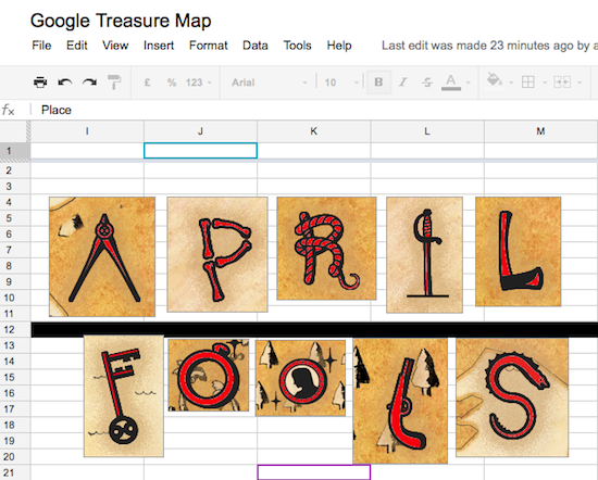
So I started solving the puzzle immediately as did many others around the world. Someone started a collaborative Google Docs spreadsheet and I got an invitation to participate through my Twitter feed. We’d pretty much solved the puzzle by early evening the day before most people even knew it existed. I think the collaboration may have been the first to complete the puzzle although I don’t know that for a fact. It was amongst the very earliest of solutions in any case.
Here is how it appeared as we worked through the answer on Docs.

My little contribution also involved plotting all of the letters on a shared Google Map.
I was hoping that I might be able to draw a line between the points and maybe find an additional Easter Egg or something. However it appeared that individual solutions were all placed randomly and far apart for perhaps no other reason than to make it difficult to find them without solving each of the clue chains.
The most entertaining part of this was collaborating in real time with about fifty people — all strangers to me — from around the globe in a single Doc simultaneously.
White House Easter Egg Roll

Speaking of Easter Eggs, in a more literal sense this time, I lucked into tickets to the White House Easter Egg Roll held on Monday. This is a 135 year-old tradition that dates back to the administration of President Rutherford B. Hayes in 1877. It’s become a Washington, DC area institution over the years, one of those events everyone living here has to do at least once in his or her lifetime, and one of the simple joys of being near the Nation’s Capital. It’s a sign of springtime as surely as the annual blooming of the cherry blossoms along the Tidal Basin.
This is one tough ticket. Each year the White House opens a lottery, and although tickets are free, the demand far outstrips supply. I’ve never attended the event before and my kids are getting older. So we figured if we didn’t act on the tickets this year then we might never get another chance.
It’s a rare privileged to walk on the White House lawn, even as part of a large crowd. This was only the third time I’ve done that in the many years I’ve lived here. The kids had a great time and will probably remember this forever. Even the weather was perfect. The only tiny blemish happened as we left and right after as we cleared the security gates. Then we could hear someone start to sing the National Anthem. I knew we’d just missed an opportunity to see President Obama by maybe thirty seconds. I guess that means we have an excuse to try again.
Go South to Go North
I love it when readers notice Twelve Mile Circle articles and use them as inspiration for their own personal travel adventures. Please send a message to me whenever you do that. Unlike some of your friends, family or loved ones, 12MC understands your geo-oddity obsession. Of course it’s worthy of accolades and attention. I want to share your stories with fellow enthusiasts who will find them endlessly fascinating.
“Kevin” was influenced by North AND South, an article about a town named North located south of the South Carolina capital and southeast of Due West. Additionally he was influenced by All Ways – Every Cardinal Direction. There I imagined anyone could travel to neighboring states in numerous counterintuitive ways given sufficient motivation.
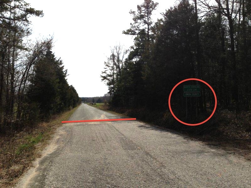
Kevin traveled to a point outside of Charlotte, North Carolina marked on the map. I’ve edited Kevin’s photo, below, by adding a line on the border and a circle around a sign that reads “North Carolina State Line – Union County.” I had to shrink the photo down to make it fit within the margins of 12MC so hopefully my additions will increase the clarity. It might be more legible if you open the image in another tab, too.

Traveling here, one can drive south from the state of South Carolina into North Carolina, and vice versa. Go south and hit north. Go north and hit south. This isn’t some insignificant border anomaly either. It’s actually rather more noticeable than many of the tiny border nicks I pointed out in my previous article. Also, at least for now, Street View does not provide coverage here. This will be your only chance to view the spot unless you go there personally.
Thank you Kevin!

Leave a Reply