We have lots to talk about today in convenient bite-sized morsels. Time passes, familiar stories change, unexplored topics surface, and readers continue to contribute great ideas (thank you!). It’s a convenient moment to dust-off a periodic recurring theme on 12MC. I call it “Odds and Ends.” Like a bad movie spawning endless sequels, the Twelve Mile Circle now hits miscellaneous article #6 with no end in sight.
I’ll begin with a contribution from longtime reader “Ian” (who should feel free to further identify himself in the comments if he so chooses).
U.S. State Latitude Extremes

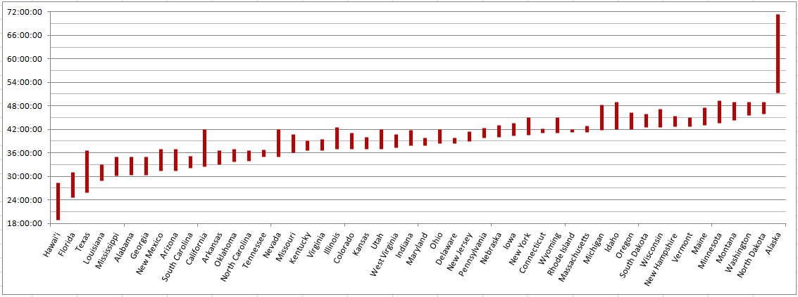
You will want to open the image in another tab to truly appreciate its elegance. This is a chart showing latitude extremes for the fifty United States laid-out sequentially. It came from an Excel spreadsheet that Ian created for that purpose.
About a thousand different project possibilities building upon these data came to mind in a nanosecond. For instance, I’d love to do the same thing for longitude. Then I would create a map of the United States based upon the four cardinal direction extremes of each individual state. I think it would result in all sorts of interesting anomalies and overlaps. Certain states like Colorado and Wyoming wouldn’t change. However, irregularly-shaped Florida, Idaho, California, Virginia and such would blossom in size.
Then I’d have to consider whether I’d need to convert coordinates to great circle distances. That would account for lines of longitude moving closer towards each other as one progresses further north (e.g., Colorado isn’t actually a rectangle). Then I could expand the concept to other continents or to the entire earth itself.
Unfortunately the thought intersected with inconvenient realities related to employment and family obligations. I quickly realized my ambitions outstripped my available time. I might revisit this later although I’d be happy to let Ian or someone else take a crack at it.
Where Does the Line Go?
Frequent contributor “Thias” forwarded a map link to border weirdness between Oman and the United Arab Emirates, including international boundaries cutting through towns plus a double enclave.
All kinds of Omani – UAE boundary madness exists. For instance, 12MC discussed the condominium that exists between the two nations back in the early days of the blog. I almost wish I could call a “do over” and rewrite the entry. Many of the early Twelve Mile Circle articles cherry-picked the most visible geo-oddity topics without the same level of detail and research I’d probably provide today.
Going in Circles

Google Maps still lacks a circle drawing tool. It seems to be such a basic necessity, and yet, it continues to be ignored. Fortunately Google offers an application programming interface that allows the public to customize enhancements.
I mentioned the circle drawing tool available from freemaptools.com in a previous article. I noticed that it’s been enhanced to allow users to embed images. Previously I had to take a screen print, create a graphics file and upload the result to my server. That was a pain. This new method is much simpler.
As an example, I created a twelve mile circle (you’d expect otherwise?) around the Zero Milestone marker in Washington, DC to test how it might work after dropping the code into a webpage. I also played around with some kilometre circles and noticed that a specific number of clicks from the marker cuts directly through my house. I mean exactly through it, as in the spot where I’m sitting right now typing this. However I can’t show that because I don’t want my exact location displayed on the Internet.
The site also used an animated gif as its favicon (may not work on all browsers) which has nothing to do with mapping; just something that amused me.
Life is tough along the American Meridian
The location of the one-and-only 12MC Happy Hour has closed. Again. The spot was crucial — on the dividing line between the U.S. version of the eastern and western hemispheres prior to the adoption of the meridian at Greenwich. We delayed our initial gathering after the Irish bar found there shut down. Eventually a BBQ joint moved into the space and our gathering proceeded. Now it’s gone too after barely more than a year… and just when I was thinking it was time for another get-together.
Dust Bowl Update
Thanks to everyone who provided Dust Bowl suggestions. I’ve added them to the map.
Volcanoes. Dinosaurs. Scenic Vistas. Time Zones. Keep them coming! I’ll add them no matter how trivial or obscure. I’ll try to include as many as I can in my travel itinerary.

Leave a Reply