I’ve been collecting a bunch of oddly shaped and unusually themed neighborhoods and didn’t know what to do with them. They didn’t have any similarity amongst them, even appearing in completely different parts of the world, although I wondered if perhaps I could force them into a set anyway.
The first notion that came to mind was that maybe these were examples of urban planners getting bored and playing around with some designs. That was the hope. As often happens, the more probable stories behind the scenarios I’d uncovered were considerably more complicated and entirely more interesting.
Catch Some Z’s
What was the reasoning behind all of the streets beginning with Z in the Surrey Downs neighbourhood in suburban Adelaide, South Australia? Zanoni, Zealand, Zed, Zoe, Zephyr, Zenith, Zuleika, and Zariba. That was impressive. Then I noticed a concentration of Y streets immediately to the northwest. Aha! An alphabet theme! Actually, no. Just Y and Z.
The pattern broke as I spotted the wines to the west. Zinfandel, Shiraz, Riesling, Tokay, Trebbiano, Malaga. Then I understood. The planners worked backwards starting with Z, then Y, then they got drunk and gave up, switching to wines instead.
More likely, they named streets for the grapes that went into wines rather than the actual wines themselves. The neighborhood replaced an agricultural area that included viticulture. The old adage of suburbs named for what they destroyed apparently held true here.
And no, I never did figure out the Z thing.
Like a Bloodshot Eye
What a great shape I thought when I spotted the bloodshot eye on a map from afar and drilled-in to take a closer look. It was like a cartographer decided to doodle absentmindedly in the margins of a page and happened to sketch an eye, or a wagon wheel or a whatchamacallit.
This seemed like a well-populated area with a high probability of Street View coverage. I zoomed in even farther and I couldn’t find anything at ground level. It took me a few breaths to figure out the reason why: cars can’t use these “streets.” They’re more akin to sidewalks.

What was going on? Who would build such an odd arrangement without any automobile access?
The Borough of Pitman provided an explanation. I’d discovered an historical location known as Pitman Grove.
“It developed from a summer camp meeting at the turn of the century. In the center of the Grove area is the Camp Meeting Auditorium… the center of Methodist worship. People came from far away for revival meetings… There are 12 ‘avenues’, representing the disciples of Christ, that are joined to the auditorium as spokes on the hub of a wheel. There is a spot in the tabernacle where you can stand and look down all 12 avenues. Eventually small cottages were built on these avenues and this was the origin of the town.”
The page went on to explain that Pitman remains a dry town even to this day. Pitman and Surrey Downs probably wouldn’t be very good Sister City matches.
The Ultimate Alphabet Grid
Kwazakele took me aback with its intense street layout and naming convention. It formed a part of Ibhayi, an African township formed outside of Port Elizabeth, South Africa during the Apartheid era. I discovered remarkably little information about this township on the Intertubes in spite of a population exceeding 250,000 residents.
This unusual road grid, I imagine, was probably imposed upon the inhabitants by Apartheid powers rather than rising organically on its own. The regimentation of three-letter streets beginning with A, and an offshoot section with B seemed entirely too bureaucratic. Most of the letter combinations lacked any meaning beyond a designation of geographic placement. Other streets, by coincidence, spelled words. People could end-up on roads such as Ant, Ape, Ale, Arf and even Any Road. Living on AOK would be, well, A-OK. Over at letter B, an address on Bad Road would be bad although not the worst choice possible.

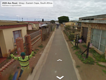
Somebody had to live on Ass Road, a most unfortunate three-letter combination. Even the guy on Street View begged for mercy.

Leave a Reply