Something needed to be done about the clutter. My list of potential topics grew to unmanageable proportions once again so I decided to keep pruning. I discovered an island theme as I sorted through the pile so I lumped a few items together. Nothing much unified them except that they involved islands with unusual twists. Twelve Mile Circle didn’t really need any more than that to get things going.
Lord Howe Island Group

My mental journey began with the Lord Howe Island Group (map). They sat within the Tasman Sea off of the eastern coast of Australia, unknown until spotted by Henry Lidgbird Ball in 1788 as he sailed towards Norfolk Island to establish a penal colony. He named the tallest of the islands, a jagged volcanic peak rising mightily into the sky, Ball’s Pyramid. He named one of the more dramatic peaks on the main island Mount Lidgbird. His legacy secured, he decided to suck-up to his superior by naming the main island after Lord Howe. Richard Howe, First Earl Howe, was the First Lord of the Admiralty at the time.
Ball claimed the island group for Britain. Initially whalers used it as a convenient place to replenish provisions. Then a permanent settlement followed. Eventually the group became part of Australia as that nation formed. It’s now an unincorporated area of New South Wales. Few people live there though — only 360 residents as of the 2011 Census — and the government limits tourism because of the fragile ecosystem of such a small place. Given that, a maximum of about 800 people occupy the space at any given time.
The Twist: Lord Howe Island made a credible claim to being located within the world’s least populated time zone. This island group uniquely occupied Coordinated Universal Time (UTC) +10.5. Fewer than a thousand people ever set their watches to observe this time zone at any given moment. That contrasted with UTC +8 (the one with China) with a population of 1.7 billion.
Smith Islands

I remained in Australia momentarily, focusing on the coast of Queensland near Mackay. There I found the Smith Islands (map), the site of a national park of the same name. Those unspoiled islands offered very few amenities other than their natural beauty. People traveled there by boat, private or charter, for fishing, diving and wildlife excursions. They needed to be self-reliant during these excursions. Visitors might be completely isolated with little help available anywhere around them should any difficulties arise. Nonetheless, the park attracted a certain type of adventurer who relished unspoiled experiences and abundant solitude.
The Twist: While I never discovered who named the islands or how they chose the theme, they did follow a consistent pattern. Imagine every kind of smith — skilled metal workers — and it had its own island named for it. I saw Ladysmith, Blacksmith, Silversmith, Coppersmith, Goldsmith, Anchorsmith and Tinsmith.
Some readers may remember the 12MC article I called Ladysmith, and yes that’s how I found this island group. I liked Blacksmith Island most of all. Nearby stood Hammer Island, Anvil Reef, Forge Reef and Pincer Island, enough tools to create an entire blacksmith shop. Other features figured into the general theme as well, including Ingot Island and Bullion Rocks.
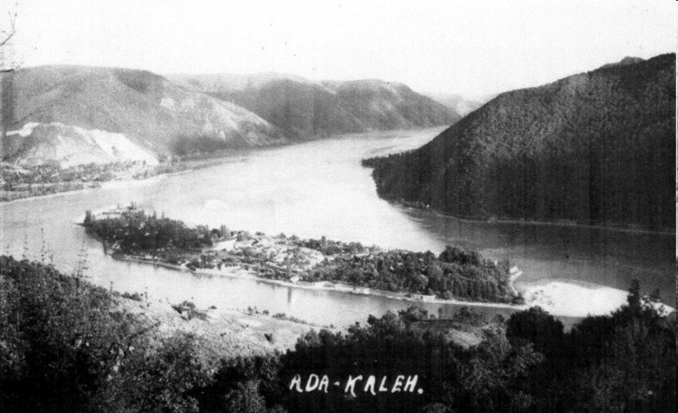
Ada Kaleh

Ada Kaleh experienced a convoluted history. This small island sat in the Danube River between modern-day Romania and Serbia, just downstream from Orsova (map). It became a strategic point along the river, a place taken and retaken repeatedly by the Austrian and Ottoman empires starting in the 17th Century. The name of the island itself came from a Turkish word, Adakale, meaning Island Fortress.
The real weirdness started in 1878 when the Ottomans lost control of the surrounding area as a result of losing the Russo-Turkish War. Everyone just sort-of forgot about Ada Kaleh during the peace talks so it became a Turkish exclave. It transformed into something of a lawless territory, a haven for smuggling and other nefarious activities. The situation remained that way for about a half-century when another treaty corrected the error. However, even afterwards it retained its distinct Turkish attributes and culture even though if fell within the physical confines of Romania.
The Twist: Ada Kaleh no longer exists. The waters of the Danube rose considerably along this stretch of the river after construction of the Iron Gates Dam in 1972. Most of the island’s residents chose to relocate to Turkey rather than remain in Romania.
Isle of Dogs

The River Thames takes quite a curve in east London, enclosing a small area on three sides (map). Technically this isn’t an island at all so it probably shouldn’t even be on my list. I found it while Marking the Meridian. The Isle of Dogs wasn’t that distant from the Royal Observatory at Greenwich, and the meridian came oh-so-close to crossing through it. Despite its name, somehow it attracted commercial enterprises in the modern era particularly for banking and finance.
The Twist: Well, other than the fact that it wasn’t actually an island, nobody knew how it became the Isle of Dogs. East London History said,
“The original name for the island was Stepney Marsh or Stebunheath. It is thought that the Isle of Dogs name originated in the 16th century. Nobody really knows where this name came from, but there are plenty of theories. Some say that the name was given to the area because of the number of dead dogs that washed up on its banks. Others think that the modern name is a variation of other names given to the area, such as the Isle of Dykes or the Isle of Ducks.”
Dogs or Dykes or Ducks (or others). Take your pick.

Leave a Reply