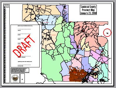
A small wedge of Sandoval County, New Mexico hovers off its eastern edge. It is a fully disembodied and totally separated from the remainder of the county. Thus, it’s a great example of an orphaned exclave.

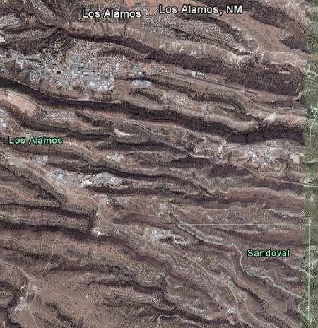
Google Earth captures this exclave rather nicely. Roughly it’s triangular, with a right angle on the northeast corner.

Santa Fe County borders the shorter leg along eastern edge. Meanwhile, Los Alamos County borders the northern leg and its jagged hypotenuse. The Sandoval shard extends perhaps a couple of miles at its greatest length. Therefore, its total area is perhaps a square mile or so if I’m recalling my junior high school geometry correctly.
Where it Fits
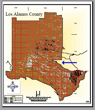
Next, let’s take a look at Los Alamos County, particularly towards the eastern edge where I’ve drawn the blue arrow. Indeed, the Sandoval exclave fits neatly into the Los Alamos gouge like a perfect piece from a geographic jigsaw puzzle.

The border between Sandoval and Santa Fe Counties formed roughly a straight line prior to the existence of Los Alamos County. Look at the Los Alamos map again. Now mentally re-draw the original line along that straight portion of the eastern border (by extending it further south). Everything to the left of the line came from Sandoval County excepting the exclave which remains part of Sandoval. Everything to the right of the line came from Santa Fe County.
Manhattan Project
Los Alamos County is a recent creation as far as counties go. Its roots date back only to 1943 and the Manhattan Project. The Federal government toiled urgently during those dark days of the Second World War, creating a nuclear arsenal in total secrecy. Military leaders needed to find a remote spot away from prying eyes but not completely without infrastructure. So they seized the Los Alamos Ranch Boys School and its surrounding land by eminent domain. Los Alamos fell under the control of the Manhattan District of the U. S. Atomic Energy Commission practically overnight. It would become the birthplace of the atomic bomb.
Since this was a Federal action in support of a vital military mission during wartime, the commanders in charge didn’t much consider niceties such as county boundaries or personal property. The entire site became a heavily restricted, highly classified atomic research facility for the duration of the war. A military town arose alongside the Masters’ Cottages of the former Boys School to house the scientists and researchers as they toiled on their nuclear mission. It remained a “gated community” closed to unauthorized visitors even until 1957 according to the Los Alamos Historical Society.
After the War
The Federal government loosened its grip and returned these seized lands to state control in 1949. At that point, New Mexico decided to create a new entity, Los Alamos County, rather than return the territory to its two parent counties. The town of Los Alamos became its county seat.
This would provide a closer focus on the highly specialized purpose and nature of the Los Alamos laboratories and the needs of its inhabitants. As an odd byproduct, it simultaneously created the Sandoval County exclave by default. This was a strange leftover arising from the original Federal territorial seizure.
But Why?
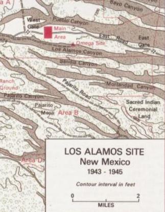
The Sandoval County exclave clearly exists without any doubt. Area maps including those produced by Sandoval County itself explicitly recognize it. However, it’s less clear exactly why the exclave exists. Wouldn’t it have made as much sense, perhaps more so, for this tiny sliver of land to have become part of Los Alamos County? Why would it remain part of Sandoval while distinctly detached from it? Perhaps this detail from a Department of Energy map of Los Alamos, 1943-1945, provides a clue.

There are two important points one can draw from this map. First, the Sandoval triangle never existed within Los Alamos even at its inception in 1943. Second, the labeling unmistakably calls it “Sacred Indian Ceremonial Land”. So now things begin to make a little more sense. It holds a special meaning to the nearby San Ildefonso Pueblo. Government officials handled it with deference even as Los Alamos rose from the mesa.
Perhaps the government concluded that separating an ancient community from its sacred land would have created a natural incentive to sneak through a security perimeter. On the other hand, I would like to hope that they kept the triangle outside of Los Alamos’ boundaries for empathetic reasons. Either way, it happened by design and it took place from the beginning. Nobody expected Los Alamos to form a distinct county when the government seized it. This was a “temporary” wartime measure.
A Possible Explanation
So then, why not just append it to the county immediately to the east, Santa Fe County? I don’t know why exactly but as we’ve seen many times on Twelve Mile Circle, once a chunk of land becomes geographically isolated from its parent, the parent will continue to hold onto it if it can (for example, Carter Lake, Iowa and Kaskaskia, Illinois). While I don’t have the evidence to prove this conclusively, I do think it’s a reasonably plausible explanation. I invite rebuttals and would be happy to add a better explanation if evidence contradicts this supposition.
I also invite comments from anyone who may have visited the Sandoval exclave. Given its sacred nature I’ll personally respect its boundaries. So while I consider this an interesting curiosity I’m unlikely to visit it myself.

Leave a Reply