Twelve Mile Circle mentioned Sault Ste. Marie the other day, the name of two cities on opposite banks of the St. Marys River, one in Canada and the other in the United States. The curious prefix “sault” jumped-out of course, and while I was aware that it should be pronounced something akin to “soo” I’d certainly never examined its etymology before. I just took it on faith that it was an odd word with an unusual pronunciation.
As the city on the US side of the border in Michigan explained,
“While there is some debate on the exact meaning of ‘Sault,’ scholars of early French note that the word translates into jump, referring to the place where one needs to ‘jump’, or put into the St. Mary’s River. This translation relates to the treacherous rapids and cascades that fall over 20 feet from the level of Lake Superior to the level of the lower lakes.”
It was an archaic word. French explorers carried it to the Great Lakes and applied it to various spots wherever treacherous river rapids required portages. Then it shifted in meaning slightly in Canadian French / Français Canadien to refer to the rapids themselves. Websters said, “(1) obsolete : leap, jump;… (2) a fall or rapid in a river ” Those familiar with the word “somersault” will notice a similar history. The usage began to make more sense.
So could 12MC find other places where the archaic Sault existed as an artifact of those early French explorations? Yes, primarily in Canada and to a lesser degree in immediately adjacent areas of the United States.
Long Sault

I discovered two noteworthy Long Sault placenames, one in Ontario and the other in Québec. This made sense to me because of multiple river obstacles that would have seemed quite lengthy and inconvenient to those portaging around them.
In Ontario
Ontario’s Long Sault (map) remained as such in name only. As explained on the St. Lawrence Parks page for the Long Sault Parkway,
“… a group of eleven islands west of Cornwall, Ontario, was created by St. Lawrence Seaway flooding in 1958. The islands, formerly part of the Canadian mainland before the flooding of the Long Sault rapids, are a major tourist attraction…”
Long Sault became a rather tame, tourist-friendly stretch, with roiling whitewater replaced by a leisurely flow. Nonetheless the parkway, plus an adjacent unincorporated urban community within South Stormont township, and a set of islands on the US side of the border all retained the Long Sault name afterwards.
In Québec
The Long Sault rapids on Québec’s Ottawa River had an even more interesting history. The Battle of Long Sault took place there:
“In the spring of 1660, [Adam Dollard des Ormeaux] and his men left Montreal, heading northwest up the Ottawa River… When the party arrived at an abandoned fort at Long-Sault that had been built by the Algonquins the previous autumn, they were joined by a war party of 40 Hurons and four Algonquins. Totally unexpectedly, another war party then appeared, this time not allied but enemy and much stronger. It consisted of about 200 Iroquois warriors, who were as surprised to stumble across the French as the French were to run into them.”
It didn’t end well — the French defenders accidentally blew themselves up. Nonetheless, period accounts described it as a great French “victory.”
Much later, in 1833, the Carillon Canal bypassed the rapids (map). The canal still exists and operates as the Carillon Canal National Historic Site. It includes a single, functional 20 metre lock that serves the recreational boating community primarily.
Sault-au-Récollet

The Sault-au-Récollet neighbourhood is in Montreal (map). Récollet referred to the Recollects, a French branch of the Friars (also known as Franciscans). The Recollects became very early explorers and missionaries in the region, and arrived with Samuel de Champlain. They even predated Jesuits explorers who would later overshadow them.
So this would lead one to believe that Sault-au-Récollet might be a very old name, and indeed that was the case. A website about the neighborhood explained the name and I’ll provide the original French followed by the crappy Google Translate version in English:
“En 1625, le récollet Nicolas Viel, un missionnaire français, et son compagnon Ahuntsic, un jeune français vivant à l’Amérindienne, se noient dans les rapides. Ce lieu est désormais nommé Sault-au-Récollet…” In 1625, the Recollects Nicolas Viel, a French missionary, and his companion Ahuntsic, a young French living Native American, drown in the rapids. This place is now called Sault au Recollects.
Grand-Sault

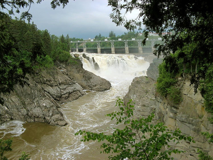
The grand falls on the Saint John River remained quite spectacular throughout the ages. They dropped some 23 metres in quick succession. This location gave rise to the city of Grand-Sault / Grand Falls in New Brunswick (map), right on the border with the United States just east of northern Maine.
The city’s “Did You Know” page contained an interesting trivial tidbit: “Grand Falls is one of two municipalities in Canada with its name in both official languages: Grand Falls/Grand-Sault.”
What was the other? I knew it would drive me nuts so I had to drop everything and find the answer. Fortunately I stumbled across Public Works and Government Services Canada without expending too much effort.
“15.04 Names of inhabited places. Only two municipalities in Canada have two official forms of their names, one in English and one in French: Grand Falls and Caissie Cape in New Brunswick, which are also known officially as Grand-Sault and Cap-des-Caissie. All other municipalities have only one authorized form: thus Montréal and Québec (the city) retain their accents in English.”
Problem solved. Canadian 12MC readers now have something to cite during casual conversations.
Other Places
The Canadian Geographical Names Data Base included several other occurrences of Sault. They were all in Québec.
- Sault-Blanc (Falls)
- Sault McKenzie (Falls)
- Sault Noir (Falls)
- Sault-Saint-Lin (Unincorporated area)
- Sault-au-Cochon (Unincorporated area)
- Sault-au-Mouton (Unincorporated area)
- Sault-à-la-Puce (Unincorporated area)
First Nations / Native Americans
The sault connection extended to some of the original inhabitants of those places explored by the French.
The Saulteaux First Nation of Cochin, Saskatchewan, once lived in an area north of Sault Ste. Marie. They are an Algonquian group with an alternate name, the Plains Ojibwa. Another First Nation called the Saulteau First Nations in Chetwynd, British Columbia, also exists. One source noted that they “originated from Manitoba and was formed by the amalgamation of Beaver, Cree, and Saulteau residents”. I could not identify them to a specific “sault” though.
On the other side of the border one finds the Sault Ste. Marie Tribe of Chippewa Indians of Michigan, often shortened to the Sault Tribe.

Leave a Reply