A Secret Revealed

Don’t you hate misleading headlines? I’m not really revealing a secret because it hides in plain sight. The information was publicly available as long as one knew where to search for it. I’m talking about a so-called “secret” Interstate highway route recently outed by the District Department of Transportation in Washington, DC.


Unsigned Interstates

There are a number of secret Interstates. Actually, more properly transportation officials call them “unsigned” Interstates. Lists of them exist all over the place. I guess if I wanted to get even more technical I should call them unsigned Auxiliary Interstates because they all have 3-digit designations. I’m not a road geek so please forgive my lack of precision. I know this actually matters to some of the 12MC audience.

Lots of sites on the Intertubes insist that there are 21 secret interstate routes without bothering to list them, repeating the mantra verbatim as if it’s fact. The version of the list on Wikipedia includes 14 of them.

The most comprehensive list I found (meaning it requiring the least amount of effort using a search engine) is AARoads’ Interstate Guide. This site lists 22. However it includes four roads in Alaska and three in Puerto Rico, not all necessarily built to Interstate standards although they are part of the Interstate Highway system. Yes, I know, let’s try to not get too hung up on Interstates in a state that’s not connected to any other state or to a territory that’s not even a state. Similar issues exist for Hawaii and the District of Columbia. Let’s not take “interstate” too literally.


District of Columbia Interstate 695

Nonetheless, what I’m trying to say (and failing badly) is that there’s one less fewer 🙂 secret Interstate as of December 2011. The District decided to sign I-695. [link no longer available].

“Well, actually, there is an I-695 in DC and there has been on for a long time. But while residents and commuters are intimately familiar with I-295 and I-395, you can’t blame them for not knowing where I-695 is located; as far as we can tell it was not previously signed although it was shown on some maps. I-695 has been the designation for a portion of the Southeast/Southwest Freeway, beginning where I-395 enters the Third Street Tunnel and extending to the northern side of the 11th Street Bridge, a grand total of 1.4 miles”

Secret Interstates exist for lots of reasons. The most common cause is that they already had a well-established name when they were upgraded to Interstate status. I’m not going to talk about every instance –you are free to peruse the lists yourself — but I will select a few of my favorites.


Maryland Interstate 595

US Route 50 - Maryland. Photo by Doug Kerr; (CC BY-SA 2.0)
U.S. Route 50 (a.k.a. I-595 near Annapolis, Maryland)

I’ve driven Maryland I-595 probably a hundred times. Anyone heading away from Washington, DC for a weekend at the nearest beach likely does the same. Growing up, I’d always thought of it as Route 50. Others call it the John Hanson Highway (map). It was a pretty difficult drive back then. Maryland upgraded the section from the Capital Beltway to Annapolis to Interstate standards in the 1990’s. They didn’t change the name because everyone, myself included, already believed it had a perfectly acceptable name. Nobody calls it I-595.

This unsigned Interstate highway extends nearly twenty miles, the longest in the system.


New York Interstate 478

I like New York I-478 because it’s mostly underwater. Most everyone calls it the Brooklyn–Battery Tunnel (although Google Maps seems to like I-478). The Metropolitan Transportation Authority says thatWhen the Brooklyn-Battery Tunnel opened in 1950, it was the longest continuous underwater vehicular tunnel in North America. It still is.” Drivers cross beneath the East River and Governors Island nearly two miles as they travel between Long Island and Manhattan. They get to pay a lot of money for the privilege too, if using cash.

UPDATE: this became the Hugh L. Carey Tunnel in 2012.


Louisiana Interstate I-910

Crescent City Connection. Photo by howderfamily.com; (CC BY-NC-SA 2.0)

Louisiana chose to designate I-910 as Business Route 90, extending from New Orleans to Westwego in Jefferson Parish (map). I like this one because it crosses the Mississippi River on the Crescent City Connection, subjecting drivers to the geo-oddity I described in, “Where West is East.” Louisiana does have a bit of an ulterior motive. They envision I-910 as part of a future extension of Interstate 49 that will stretch from here to Lafayette. Why rename it when it’s going to change anyway?

Comments

11 responses to “A Secret Revealed”

  1. David F-H Avatar
    David F-H

    Ahem, also of importance to some geo-nerds is grammar. The sentence under your first map uses ‘less’ where it should use ‘fewer.’

    I did notice when in PR when driving from San Juan to Ponce the road seemed eerily familiar and noticeably better quality than the rest of the roads. My passenger didn’t believe me that it could be interstate standards.

    As for New Orleans, I didn’t make that drive but I recall thinking the bridge might be a little underpar for interstates? (This from a former resident of the Twin Cities in Minnesota, a little paranoid these days about bridges.)

    Great post!

    1. Rhodent Avatar
      Rhodent

      David: The idea that you can’t use “less” with count nouns is a myth. Linguists have found the origin of this idea, and it all goes back to one person’s opinion back in the latter part of the 18th Century (and I say “opinion” because what he wrote about it makes it clear he was simply stating his preference, not declaring an actual rule). Meanwhile, the use of “less” with count nouns is attested to non-stop for over 1100 years.

      For more detail, check out http://books.google.com/books?id=2yJusP0vrdgC&pg=PA592&vq=%22less,+fewer%22&dq=less+fewer+date:1990-9999&as_brr=1&source=gbs_search_s&sig=ACfU3U2vs6nUKTDkWMyLBxzjTT3NiessYA#v=onepage&q=%22less%2C%20fewer%22&f=false

    2. kacey Avatar
      kacey

      I love it when two analytical minds try to outsmart one another.

  2. Phil Sites Avatar

    I’ve been on 695 a couple times I think but try to avoid driving in the heart of the District altogether. As for 595 – done it many times as well and had no clue it was an interstate – though it certainly has the feel of one. I’ve also been on the one in Great Falls, MT and maybe the one in Bismarck, ND – not sure…

    Those Alaskan and Puerto Rican ones are much longer than Maryland’s, though it’s tough to accept them as “interstates” as we know them. Can’t speak for the Alaskan roads, but I drove PR-3 back in October and it was alright – though not up to the same standard as the much nicer PR-66 Expressway.

    1. Twelve Mile Circle Avatar

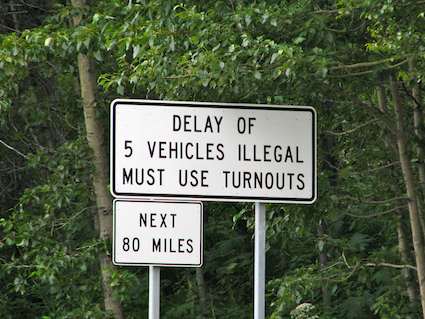
      The Alaska " Interstates" onto the Kenai Peninsula are not Interstate quality. They are undivided and a single lane in each direction, with frequent road crossings. They do have one really cool feature:


      Maintain the Speed Limit
      My All-Time Favorite Road Sign

      1. Peter Avatar

        I’m not quite sure exactly what this sign prohibits.

        1. Twelve Mile Circle Avatar

          If, say, an RV is slow-poking along and five vehicles catch up to it, the vehicle must pull over at the next turnout so all the other vehicles can get past it.

  3. Jon P Avatar
    Jon P

    Don’t forget the opposite problem: interstates that shouldn’t be. On the first day of my border crossing vacation last year (I picked up 11 new ones, including the ultra-rare SD/MT – that one’s worth a post all by itself) I drove through Cheyenne and got to travel the full length of Interstate 180 – all five traffic lights included. There are a couple more of these aberrations out there – most readers in the Northeast will be familiar with the two at-grade intersections on I-78 in Jersey City, right outside the Holland Tunnel.

  4. Dave Avatar
    Dave

    Louisiana plans to eventually extend Interstate 49 (which currently ends at I-10 in Lafayette) along US-90 (which is mostly freeway already) through New Iberia, Morgan City, Thibodaux and back up to New Orleans along I-910 (currently signed as US-90-Business). This really makes compass-directed people’s heads explode, as from New Orleans, you could go “north” on I-49 to Lafayette, which would really be east, then south (!), then west, then southwest (!), then northwest. It also would make I-10 and I-49 intersect twice, over 100 miles apart.

  5. Doug Rose Avatar

    Just wanted to say how much I enjoy your blog! I still refer back to it from time to time for reference. Planning to visit DC this summer with family, and it’s a good resource for those of us who love geographic oddities!

    1. Twelve Mile Circle Avatar

      Be sure to check out the DC Page if you want to see the location of every reference to the District of Columbia on this site.

Leave a Reply

Your email address will not be published. Required fields are marked *

Latest Comments

  1. I am in La Libertad, El Salvador. Was absolutely astonished to see the sun rise at one end of the…

  2. Thank you for this information. I was searching “closest distance between towns of opposite elevations” and reveals zero results, at…

  3. I agree with a two mile run with admission proceeds go to the local Hancock schools in maryland doing it…

  4. Rock Springs Campmeeting is not the only one in NC. There’s also Balls Creek Campground, McKenzie’s Grove, and Mott’s Grove;…